Sunrise Lake
No. 485
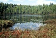
Photo by U.S. Forest Service
Sunrise Lake features a significant acreage of older natural red and white pine-dominated forests. Hemlock, including a small amount of old growth, is also found here in unusual abundance, with good regeneration occurring in a few places. Pine does well on the sandy soils found here, where competition from hardwoods is not severe. In some areas, only one pine species occurs, though a mixture of both is the usual case. Sizes range up to 26 inches in diameter for red pine and at least 36 inches in diameter for super-canopy white pine. The pine stands nearly always have an understory of red maple/red oak and early-successional species, but in some areas, white pine exhibits excellent regeneration and is the dominant understory species.
Hemlock is scattered nearly throughout the complex, but in a few places occurs in dense, fire-origin stands with pine super-canopies. Hemlock sizes in these stands are generally less than 16 inches, but a small grove of old-growth hemlock with diameters of 36 inches is present at the edge of a lowland stand which probably afforded protection from the fires which once swept through this area. Other upland stands contain various mixtures of pine, red oak, red maple, balsam fir, sugar maple, paper birch, aspen, beech, and the uncommon butternut. One area contains large open-grown red oak with butternut up to 28 inches in diameter that appears healthy. Common ground layer species include blackberries, bracken fern, winterberry, and pipsissewa, with maple-leaved Viburnum, leatherwood, and eastern hop-hornbeam found in the more mesic and nutrient-rich stands.
Located along Macauley Creek are very high-quality white-cedar or swamp hardwoods. Spurred gentian, royal fern, and numerous orchids are present, and dwarf scouring rush (Equisetum scirpoides), rather uncommon in Wisconsin, is abundant along the creek. At the north edge of the complex is a mixed swamp of black ash, white cedar, red maple, yellow birch, and hemlock with a population of the rare white adder's-mouth (Malaxis brachypoda). To the south, a small bog lake is surrounded by a black spruce-tamarack swamp. Rock outcrops, though not as extensive as in the nearby Hager Mountain LAD complex, add significant diversity. For its size, the Sunrise Lake complex contains a remarkable diversity of quality habitats. Sunrise Lake is owned by the US Forest Service and was designated a State Natural Area in 2007.
Very few State Natural Areas have public facilities, but nearly all are open for a variety of recreational activities as indicated below. Generally, there are no picnic areas, restrooms, or other developments. Parking lots or designated parking areas are noted on individual SNA pages and maps. If a developed trail is present, it will normally be noted on the SNA map and/or under the Maps tab. A compass and topographic map or a GPS unit are useful tools for exploring larger, isolated SNAs.
The good majority of SNAs are isolated and have few or no facilities. Some SNAs have vehicle access lanes or parking lots, but their accessibility may vary depending on weather conditions. Parking lots and lanes are not plowed during winter. Hiking trails may be nonexistent or consist of undeveloped footpaths. A GPS unit or compass and a detailed topographic map are useful tools for exploring larger SNAs.
Non-DNR lands
Entrance fees: For non-DNR-owned SNAs, we are unaware of any vehicle or admission fees. However, please contact the landowner for more information.
Hunting and trapping
Other activities
Other allowable activities such as - but not limited to camping, geocaching and bicycling are determined by the landowner. Please contact them directly or visit their websites for details.
Location
Within the Chequamegon-Nicolet National Forest. Oconto County. T32N-R17E, Sections 28, 29, 32, 33. 593 acres.
Driving directions
From the junction of STH 32 and CTH W in Mountain, travel east on CTH W to the junction of CTH W and FR 2319 (Sunrise Lake Road). The complex lies to the northeast and southwest of this intersection.
The DNR's state natural areas program is comprised of lands owned by the state, private conservation organizations, municipalities, other governmental agencies, educational institutions and private individuals. While the majority of SNAs are open to the public, access may vary according to individual ownership policies. Public use restrictions may apply due to public safety, or to protect endangered or threatened species or unique natural features. Lands may be temporarily closed due to specific management activities.
Users are encouraged to contact the landowner for more specific details. The data shown on these maps have been obtained from various sources, and are of varying age, reliability, and resolution. The data may contain errors or omissions and should not be interpreted as a legal representation of legal ownership boundaries. To create your custom map where you can zoom to a specific location, please use the DNR's Mapping Application.
Sunrise Lake is owned by: US Forest Service