Sugar River Wetlands
No. 299
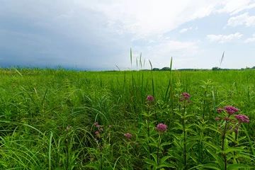
Photo by Josh Mayer
Sugar River Wetlands features a diverse wetland complex including a sedge meadow, calcareous fen, emergent aquatic, shrub-carr, and wet-mesic prairie. Located within the Upper Sugar River Watershed, this extensive wetland harbors numerous rare plant and animal species and contains the most diverse fishery in southern Wisconsin. The fen flora is diverse with many calcium-loving plants including Kalm's lobelia, grass-of-Parnassus, and shrubby cinquefoil. The carbonate-rich groundwater that percolates up from the underlying bedrock provides high-quality water to the surrounding wetlands and rivers.
Intergrading with the fen is a wet-mesic prairie dominated by tall grasses including big blue-stem, Canada blue-joint grass, prairie cord grass, and Canada wild rye. The forb component is diverse with azure aster, shooting star, prairie blazing star, prairie phlox, and culver's root. Also present is a southern sedge meadow with tussock sedge and a shrub-carr community dominated by tall shrubs such as red-osier dogwood, meadowsweet, and willows. Within these communities are several rare plants. The area is part of a larger grassland habitat restoration complex along the Sugar River, which seeks to establish landscape management areas for the benefit of declining grassland birds and animals, vegetation communities, and invertebrates that depend upon native vegetation. Sugar River Wetlands is owned by the DNR and was designated a State Natural Area in 1996.
Very few State Natural Areas have public facilities, but nearly all are open for a variety of recreational activities as indicated below. Generally, there are no picnic areas, restrooms, or other developments. Parking lots or designated parking areas are noted on individual SNA pages and maps. If a developed trail is present, it will normally be noted on the SNA map and/or under the Maps tab. A compass and topographic map or a GPS unit are useful tools for exploring larger, isolated SNAs.
The good majority of SNAs are isolated and have few or no facilities. Some SNAs have vehicle access lanes or parking lots, but their accessibility may vary depending on weather conditions. Parking lots and lanes are not plowed during winter. Hiking trails may be nonexistent or consist of undeveloped footpaths. A GPS unit or compass and a detailed topographic map are useful tools for exploring larger SNAs.
Entrance fees: Except for Parfrey's Glen, the Cambrian Outlook in the Dells of the Wisconsin River, SNAs within State Parks and some within State Forests, all other DNR-owned SNAs do not have any admission fees. For more information, see Wis. Admin. Code NR 45 [exit DNR]. For non-DNR-owned SNAs, we are unaware of any vehicle or admission fees. However, please contact the landowner for more information.
Allowable activities: DNR-owned land
The activities listed below are generally allowed on all DNR-owned SNA lands. Exceptions to this list of public uses, such as SNAs closed to hunting, are noted above and posted with signs on the property site.
- Hiking
- Fishing
- Cross country skiing
- Hunting
- Trapping
- Scientific research (permit required [PDF])
- Outdoor education
- Wild edibles (What is this?)
- Pets (Rules)
- Wildlife viewing
Prohibited activities: all SNAs
Although a handful of sites allow activities like primitive camping (e.g. Lower Chippewa River on sand bars) or horseback riding (e.g. S. Kettle Moraine), the activities listed below are generally prohibited on DNR-owned SNAs.
- Camping and campfires
- Collecting of animals (other than legally harvested species), non-edible fungi, rocks, minerals, fossils, archaeological artifacts, soil, downed wood, or any other natural material, alive or dead.
- Collecting for scientific research requires a permit issued by the DNR
- Collecting of plants including seeds, roots or other non-edible parts of herbaceous plants such as wildflowers or grasses
- Drones: Flying-related activities, including the use of drones, hang-gliders and model airplanes, are prohibited. Permission may be issued by the SNA Program for the use of drones for educational or research purposes
- Geocaching
- Horseback riding
- Rock climbing
- Vehicles, including bicycles, ATVs, aircraft, and snowmobiles except on trails and roadways designated for their use.
For rules governing state-owned SNAs and other state lands, please consult Chapter NR 45 Wis. Admin. Code [exit DNR].
Location
Dane County. T6N-R8E, Sections 17, 20, 21. 266 acres.
Driving directions
Access via the Military Ridge Bike Trail. For walk-in access: From the intersection of U.S. Highway 18 and County Highway MV (Business 18) in Verona, go east on MV about 0.3 miles, then north on Country View Road about one mile to a gated access lane. Park and walk south on the access road, then go southeast on the recreational trail into the site. For bike access: Park in the lot on County Highway PB just south of County MV and ride southwest into the area. Or from the intersection of Highway 69 and County M, go south on 69 for 1.1 miles, then west on Valley Road for 0.9 miles to a DNR parking area north of the road.
The DNR's state natural areas program is comprised of lands owned by the state, private conservation organizations, municipalities, other governmental agencies, educational institutions and private individuals. While the majority of SNAs are open to the public, access may vary according to individual ownership policies. Public use restrictions may apply due to public safety, or to protect endangered or threatened species or unique natural features. Lands may be temporarily closed due to specific management activities.
Users are encouraged to contact the landowner for more specific details. The data shown on these maps have been obtained from various sources, and are of varying age, reliability, and resolution. The data may contain errors or omissions and should not be interpreted as a legal representation of legal ownership boundaries. To create your custom map where you can zoom to a specific location, please use the DNR's Mapping Application.
Sugar River Wetlands is owned by: Wisconsin DNR