Sugar Creek Bluff
No. 338
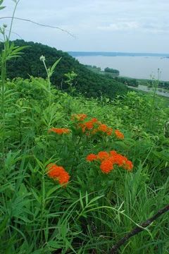
Photo by Josh Mayer
Sugar Creek Bluff features dry goat prairies on west and south-facing slopes, dry-mesic forest, and Sugar Creek, a Class 2 trout stream. The high-quality prairie is situated on bluffs overlooking the Mississippi River and contains a rich prairie flora with such species as prairie drop-seed, big and little blue-stem, New Jersey tea, flowering spurge, lead-plant, hoary puccoon, prairie coreopsis, bird's-foot violet, downy painted-cup, and bastard-toadflax. Red oak, white oak, shagbark hickory, white ash, and basswood dominate the dry-mesic forest. Although the north-facing slope has been selectively logged, the canopy remains intact.
The ground flora is diverse and includes numerous spring ephemerals and early summer species including spring beauty, dutchman's-breeches, hepaticas, bloodroot, columbine, and toothwort. Numerous rare animals are known to inhabit this dry bluff. This area is highly threatened due to a high interest in home development along the scenic Mississippi River. Protection of these unique resource areas will help secure the long-term survival of the rare plants and animals found here. Sugar Creek Bluff is owned by the Mississippi Valley Conservancy and was designated a State Natural Area in 2002.
Very few State Natural Areas have public facilities, but nearly all are open for a variety of recreational activities as indicated below. Generally, there are no picnic areas, restrooms, or other developments. Parking lots or designated parking areas are noted on individual SNA pages and maps. If a developed trail is present, it will normally be noted on the SNA map and/or under the Maps tab. A compass and topographic map or a GPS unit are useful tools for exploring larger, isolated SNAs.
The good majority of SNAs are isolated and have few or no facilities. Some SNAs have vehicle access lanes or parking lots, but their accessibility may vary depending on weather conditions. Parking lots and lanes are not plowed during winter. Hiking trails may be nonexistent or consist of undeveloped footpaths. A GPS unit or compass and a detailed topographic map are useful tools for exploring larger SNAs.
Non-DNR lands
Entrance fees: For non-DNR-owned SNAs, we are unaware of any vehicle or admission fees. However, please contact the landowner for more information.
Hunting and trapping
Other activities
Other allowable activities such as - but not limited to camping, geocaching and bicycling are determined by the landowner. Please contact them directly or visit their websites for details.
Location
Crawford County. T10N-R6W, Sections 9, 10, 15, 16. 431 acres.
Driving directions
From the intersection of State Highway 35 and County Highway C in Ferryville, go south on 35 for 0.5 miles, then north on North Buck Creek Road for 1.1 miles to a parking area and kiosk on the left. A network of old lanes provides hiking access to the northern portion of the natural area and the bluff prairie. To access the southern portion, refer to the map and park along either North Buck Creek Road or Buck Creek Road. There are no trails in the southern portion.
The DNR's state natural areas program is comprised of lands owned by the state, private conservation organizations, municipalities, other governmental agencies, educational institutions and private individuals. While the majority of SNAs are open to the public, access may vary according to individual ownership policies. Public use restrictions may apply due to public safety, or to protect endangered or threatened species or unique natural features. Lands may be temporarily closed due to specific management activities.
Users are encouraged to contact the landowner for more specific details. The data shown on these maps have been obtained from various sources, and are of varying age, reliability, and resolution. The data may contain errors or omissions and should not be interpreted as a legal representation of legal ownership boundaries. To create your custom map where you can zoom to a specific location, please use the DNR's Mapping Application.
Sugar Creek Bluff is owned by: Mississippi Valley Conservancy