Sterling Barrens
No. 147
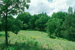
Photo by Thomas A. Meyer/DNR
Located in pitted outwash deposits laid down by glacial melt-water streams, Sterling Barrens contains a jack pine-Hill's oak dry forest interspersed with barren openings and an extensive wetland of sedge meadow and shrub-carr. The gently rolling barren openings are interspersed with prairie species. Dominant grasses are needle grass, three-awn grass, Indian grass, and big and little blue-stem. Several rare forbs are at or near their natural eastern range limit. Included in the natural area are the St. Croix River terrace escarpment and a reach of the St. Croix that contains an excellent diversity of aquatic species. The river is lined with bottomland hardwoods of silver maple, elm, black ash, and cottonwood with willow brush. Many dragonfly species are found in this portion of the river. The dry forest on the sandy uplands and the terrace slope is young but has a diverse ground layer. Adjacent to the river is a sedge meadow dominated by wide-leaved sedges, prairie cord grass, marsh fern, sensitive fern, blue-joint grass, wool grass, ironweed and Joe-pye weed. Shrub-carr areas consist primarily of willows with white meadowsweet, alder, and occasional tamarack. Low areas support stands of emergent aquatics including arrowhead, cat-tail, three-way sedge, river bulrush, hardstem bulrush, and spike rushes. Breeding bird surveys show broad-winged hawks, red-eyed vireo, chestnut-sided warblers, ovenbird and chipping sparrows as common nesters. Sterling Barrens is owned by the National Park Service and DNR. The site was originally designated a State Natural Area in 1979 and later expanded to include the St. Croix Scenic Riverway in 2002.
Very few State Natural Areas have public facilities, but nearly all are open for a variety of recreational activities as indicated below. Generally, there are no picnic areas, restrooms, or other developments. Parking lots or designated parking areas are noted on individual SNA pages and maps. If a developed trail is present, it will normally be noted on the SNA map and/or under the Maps tab. A compass and topographic map or a GPS unit are useful tools for exploring larger, isolated SNAs.
The good majority of SNAs are isolated and have few or no facilities. Some SNAs have vehicle access lanes or parking lots, but their accessibility may vary depending on weather conditions. Parking lots and lanes are not plowed during winter. Hiking trails may be nonexistent or consist of undeveloped footpaths. A GPS unit or compass and a detailed topographic map are useful tools for exploring larger SNAs.
Hunting and trapping
Allowable activities: DNR-owned land
The activities listed below are generally allowed on all DNR-owned SNA lands. Exceptions to this list of public uses, such as SNAs closed to hunting, are noted above and posted with signs on the property site.
- Hiking
- Fishing
- Cross country skiing
- Hunting
- Trapping
- Scientific research (permit required [PDF])
- Outdoor education
- Wild edibles (What is this?)
- Pets (Rules)
- Wildlife viewing
Prohibited activities: all SNAs
- Camping and campfires
- Collecting of animals (other than legally harvested species), non-edible fungi, rocks, minerals, fossils, archaeological artifacts, soil, downed wood, or any other natural material, alive or dead.
- Collecting for scientific research requires a permit issued by the DNR
- Collecting of plants including seeds, roots or other non-edible parts of herbaceous plants such as wildflowers or grasses
- Geocaching
- Horseback riding
- Rock climbing
- Vehicles, including bicycles, ATVs, aircraft, and snowmobiles except on trails and roadways designated for their use.
For rules governing state-owned SNAs and other state lands, please consult Chapter NR 45 Wis. Admin. Code [exit DNR].
Location
Within Governor Knowles State Forest and the St. Croix National Scenic Riverway, Polk County. T36-R19W, Sections 4, 5, 31, 32. T36N-R20W, Sections 34, 35, 36. 984 acres.
Driving directions
From the intersection of Highways 87 and N in Cushing, go west on 87 for 0.7 miles, then continue west on 250th Avenue for 3 miles, then north on 280th Street for 1.5 miles, then west on Evergreen Avenue for 3 miles, then south on 320th Street for 2.25 miles to the northeast corner of the site.
The DNR's state natural areas program is comprised of lands owned by the state, private conservation organizations, municipalities, other governmental agencies, educational institutions and private individuals. While the majority of SNAs are open to the public, access may vary according to individual ownership policies. Public use restrictions may apply due to public safety, or to protect endangered or threatened species or unique natural features. Lands may be temporarily closed due to specific management activities.
Users are encouraged to contact the landowner for more specific details. The data shown on these maps have been obtained from various sources, and are of varying age, reliability, and resolution. The data may contain errors or omissions and should not be interpreted as a legal representation of legal ownership boundaries. To create your custom map where you can zoom to a specific location, please use the DNR's Mapping Application.
Sterling Barrens is owned by: National Park Service and the Wisconsin DNR
Management objectives and prescriptions
- Read the Governor Knowles Master Plan [PDF] for details on the management of the DNR-owned portion of the natural area.