Starlight Wetlands
No. 613
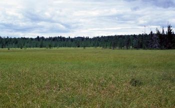
Photo by Eric Epstein
Starlight Wetlands features a diverse mosaic of natural communities representative of the Central Sands including white pine-red maple swamp, black spruce swamp, dry-mesic forest, northern sedge meadow, and central poor fen. The poor fen is a large peatland dominated by a narrow-leaved sedge over a dense carpet of sphagnum moss. Woody species such as hardhack, swamp dewberry, and cranberries are also common. In some areas are extensive patches of the common yellow lake sedge, a broad-leaved species. Along the margins of the open wetlands and within the peatland's interior are swamp conifers of black spruce, tamarack, and occasionally, jack pine. The black spruce-tamarack swamp communities occur primarily in the southeastern portion of the wetland basin.
Characteristic understory species include Labrador tea, three-seeded sedge, and huckleberry. On the upslope margins is a transition to the white pine-red maple swamp with yellow birch present. The forest is situated on shallow moss peat over moist sand and features an understory of sphagnum, cinnamon fern, skunk cabbage, winterberry, Massachusetts fern, and long sedge. Seepages and occasional spring runs are found within the forest. The dry-mesic uplands support forests of red oak, black oak, red maple, and white oak. Associates include bigtooth aspen and black cherry. The understory is quite open with a shrub layer of American hazelnut, huckleberry, bracken fern, and early low blueberry.
Pennsylvania sedge and big-leaved aster are common herbs. The forests, especially the wet coniferous forest, are noteworthy for the number of northern species they support. Among the birds are red-breasted nuthatch, hermit thrush, winter wren, Canada warbler, pine warbler, blackburnian warbler, and black-throated green warbler. Yellow-rumped warblers and yellow-bellied flycatchers occur locally in the spruce-tamarack stands. The wetlands support several rare plants including hidden-fruited bladderwort, long sedge, bog fern, yellow screwstem, and crossleaf milkwort. Starlight Wetlands is owned by the DNR and was designated a State Natural Area in 2010.
Very few State Natural Areas have public facilities, but nearly all are open for a variety of recreational activities as indicated below. Generally, there are no picnic areas, restrooms, or other developments. Parking lots or designated parking areas are noted on individual SNA pages and maps. If a developed trail is present, it will normally be noted on the SNA map and/or under the Maps tab. A compass and topographic map or a GPS unit are useful tools for exploring larger, isolated SNAs.
The good majority of SNAs are isolated and have few or no facilities. Some SNAs have vehicle access lanes or parking lots, but their accessibility may vary depending on weather conditions. Parking lots and lanes are not plowed during winter. Hiking trails may be nonexistent or consist of undeveloped footpaths. A GPS unit or compass and a detailed topographic map are useful tools for exploring larger SNAs.
Entrance fees: Except for Parfrey's Glen, the Cambrian Outlook in the Dells of the Wisconsin River, SNAs within State Parks and some within State Forests, all other DNR-owned SNAs do not have any admission fees. For more information, see Wis. Admin. Code NR 45 [exit DNR]. For non-DNR-owned SNAs, we are unaware of any vehicle or admission fees. However, please contact the landowner for more information.
Allowable activities: DNR-owned land
The activities listed below are generally allowed on all DNR-owned SNA lands. Exceptions to this list of public uses, such as SNAs closed to hunting, are noted above and posted with signs on the property site.
- Hiking
- Fishing
- Cross country skiing
- Hunting
- Trapping
- Scientific research (permit required [PDF])
- Outdoor education
- Wild edibles (What is this?)
- Pets (Rules)
- Wildlife viewing
Prohibited activities: all SNAs
Although a handful of sites allow activities like primitive camping (e.g. Lower Chippewa River on sand bars) or horseback riding (e.g. S. Kettle Moraine), the activities listed below are generally prohibited on DNR-owned SNAs.
- Camping and campfires
- Collecting of animals (other than legally harvested species), non-edible fungi, rocks, minerals, fossils, archaeological artifacts, soil, downed wood, or any other natural material, alive or dead.
- Collecting for scientific research requires a permit issued by the DNR
- Collecting of plants including seeds, roots or other non-edible parts of herbaceous plants such as wildflowers or grasses
- Drones: Flying-related activities, including the use of drones, hang-gliders and model airplanes, are prohibited. Permission may be issued by the SNA Program for the use of drones for educational or research purposes
- Geocaching
- Horseback riding
- Rock climbing
- Vehicles, including bicycles, ATVs, aircraft, and snowmobiles except on trails and roadways designated for their use.
For rules governing state-owned SNAs and other state lands, please consult Chapter NR 45 Wis. Admin. Code [exit DNR].
Location
Within the Black River State Forest, Jackson County. T20N-R2W, Sections 13, 23, 24, 25, 26. 1, 054 acres.
Driving directions
From the intersection of I-94 and County O in Millston, go east on O 4 miles to the intersection with Smrekar Road. Park and walk south 0.4 miles into the site.
The DNR's state natural areas program is comprised of lands owned by the state, private conservation organizations, municipalities, other governmental agencies, educational institutions and private individuals. While the majority of SNAs are open to the public, access may vary according to individual ownership policies. Public use restrictions may apply due to public safety, or to protect endangered or threatened species or unique natural features. Lands may be temporarily closed due to specific management activities.
Users are encouraged to contact the landowner for more specific details. The data shown on these maps have been obtained from various sources, and are of varying age, reliability, and resolution. The data may contain errors or omissions and should not be interpreted as a legal representation of legal ownership boundaries. To create your custom map where you can zoom to a specific location, please use the DNR's Mapping Application.
Starlight Wetlands is owned by: Wisconsin DNR