Standing Cedars
No. 600
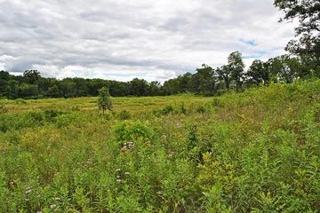
Photo by Aaron Carlson
Standing Cedars features a diversity of natural community types situated on the varied topography along the St. Croix National Scenic Riverway. A mature mesic forest of sugar maple, red oak, basswood, yellow birch, and white pine is found in a narrow gorge tributary to the St. Croix. On the bluffs and hillsides are dry prairie and oak savanna remnants that support a population of the state-threatened plant. The prairie contains a diversity of other native species such as side-oats grama grass, needle grass, prairie coreopsis, white prairie clover, prairie smoke, hoary puccoon, false dandelion, lance-leaved ground cherry, wild bergamot, wood betony, and flowering spurge. Emanating from the base of the west-facing bluffs are springs and seeps that flow to the St. Croix River.
These wet areas harbor rare grass species along with swamp saxifrage, bulblet water-hemlock, cardinal flower, northern blue flag, marsh marigold, spring cress, and water parsnip. Bird life is also diverse and includes many Species of Greatest Conservation needs. Other birds include the black-billed cuckoo, eastern wood pewee, bank swallow, veery, brown thrasher, prothonotary warbler, ovenbird, mourning warbler, scarlet tanager, and red-breasted grosbeak. Standing Cedars is owned by the Standing Cedars Community Land Trust and was designated Wisconsin's 600th State Natural Area in 2009.
Very few State Natural Areas have public facilities, but nearly all are open for a variety of recreational activities as indicated below. Generally, there are no picnic areas, restrooms, or other developments. Parking lots or designated parking areas are noted on individual SNA pages and maps. If a developed trail is present, it will normally be noted on the SNA map and/or under the Maps tab. A compass and topographic map or a GPS unit are useful tools for exploring larger, isolated SNAs.
The good majority of SNAs are isolated and have few or no facilities. Some SNAs have vehicle access lanes or parking lots, but their accessibility may vary depending on weather conditions. Parking lots and lanes are not plowed during winter. Hiking trails may be nonexistent or consist of undeveloped footpaths. A GPS unit or compass and a detailed topographic map are useful tools for exploring larger SNAs.
Non-DNR lands
Entrance fees: For non-DNR-owned SNAs, we are unaware of any vehicle or admission fees. However, please contact the landowner for more information.
Hunting and trapping
Hunting opportunities are available with landowner permission. For more information, visit Standing Cedars Community Land Conservancy [exit DNR].
Other activities
Other allowable activities such as - but not limited to camping, geocaching and bicycling are determined by the landowner. Please contact them directly or visit their websites for details.
Location
Polk County. T32N-R19W, Sections 5, 20, 29. T33N-R19W, Sections 32, 33. 866 acres.
Driving directions
From the intersection of State Highway 35 and County M in Osceola, go south on 35 for 2 miles, then west on 55th Avenue for 2.2 miles to a small parking area. Or from the intersection of 35 and M, go south on 35 for 4.5 miles, then west on 30th Avenue for 1.7 miles, then south on 280th Street for 1.1 miles to a small lane on the west side of the road. Go 0.15 miles to the Y and park. Walk south on the lane into the site. Looped hiking trails provide access to the natural area.
The DNR's state natural areas program is comprised of lands owned by the state, private conservation organizations, municipalities, other governmental agencies, educational institutions and private individuals. While the majority of SNAs are open to the public, access may vary according to individual ownership policies. Public use restrictions may apply due to public safety, or to protect endangered or threatened species or unique natural features. Lands may be temporarily closed due to specific management activities.
Users are encouraged to contact the landowner for more specific details. The data shown on these maps have been obtained from various sources, and are of varying age, reliability, and resolution. The data may contain errors or omissions and should not be interpreted as a legal representation of legal ownership boundaries. To create your custom map where you can zoom to a specific location, please use the DNR's Mapping Application.
Standing Cedars is owned by: Standing Cedars Community Land Conservancy