St. Peter's Dome
No. 420
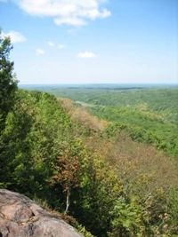
Photo by Linda Parker
The highest point on the Chequamegon, St. Peter's Dome features a stream situated on a scenic chasm surrounded by a large block of unfragmented second-growth northern hardwood forest. The stream descends the Lake Superior escarpment in a gorge, which follows a fracture in Keweenawan granite. The gorge contains several low cliffs and occasional vertical cliffs, both moist and dry. Most of the lower gorge slopes are composed of moss-covered boulders 1-3 feet in size. The exposed bedrock features are used extensively by university groups studying Precambrian geology. The upland northern mesic forest contains extensive stands of maturing hemlock-hardwood and rich sugar maple-basswood forest along with significant inclusions of "old growth-like" forest. Other forest types include black ash-white cedar swamp, mixed swamp conifer, and dry-mesic forest. The northern mesic forest is dominated by rich sugar maple and basswood with scattered hemlock, yellow birch, white cedar, and pockets of mature white pine.
Regeneration of white pine, hemlock, and white cedar is good and there are stable populations of Canada yew. The understory is rich with one of the most complete species assemblages in the Chequamegon-Nicolet National Forest. Shrubs include mountain maple, alternate-leaved dogwood, red elder, leatherwood, and American fly honeysuckle. Herbaceous species include Carolina spring beauty, trillium, bellwort, rosy twisted stalk, trout lily, wild leek, wild ginger, red baneberry, blue cohosh, and white mandarin. Open cliff faces, talus and cliff tops support an overstory of white pine, red pine, white cedar, mountain maple, gooseberries, blueberry, and bearberry. Herbs include pale corydalis, columbine, long-leaved bluets, and numerous ferns.
Of interest is the presence of rare species, including a state-threatened fern. Other notable features include the headwaters of several important cold water streams including Morgan, Frames, and Waboo Creeks, a full range of forest development in a natural matrix, the un-roaded and remote nature of the site and the widest elevation gradient on the Forest (500 feet), and the 80-foot waterfall, Morgan Falls. St. Peter's Dome is owned by the U.S. Forest Service and was designated a State Natural Area in 2007. This site is also recognized by the Forest Service as an established Research Natural Area.
Very few State Natural Areas have public facilities, but nearly all are open for a variety of recreational activities as indicated below. Generally, there are no picnic areas, restrooms, or other developments. Parking lots or designated parking areas are noted on individual SNA pages and maps. If a developed trail is present, it will normally be noted on the SNA map and/or under the Maps tab. A compass and topographic map or a GPS unit are useful tools for exploring larger, isolated SNAs.
The good majority of SNAs are isolated and have few or no facilities. Some SNAs have vehicle access lanes or parking lots, but their accessibility may vary depending on weather conditions. Parking lots and lanes are not plowed during winter. Hiking trails may be nonexistent or consist of undeveloped footpaths. A GPS unit or compass and a detailed topographic map are useful tools for exploring larger SNAs.
Non-DNR lands
Entrance fees: For non-DNR-owned SNAs, we are unaware of any vehicle or admission fees. However, please contact the landowner for more information.
Hunting and trapping
Other activities
Other allowable activities such as - but not limited to camping, geocaching and bicycling are determined by the landowner. Please contact them directly or visit their websites for details.
Location
Within the Chequamegon-Nicolet National Forest, Ashland County. T44N-R4W, Section 6. T45N-R4W, Sections 19, 20, 21, 28-33. 5,092 acres.
Driving directions
The site is approximately 15 miles south of Ashland with access from FR 199 (County Line Road), which runs along the western boundary of the site. Hiking, x-country skiing, and snowmobile trails give access to the interior. For more information, please contact the Chequamegon-Nicolet National Forest at 715-362-1300.
The DNR's state natural areas program is comprised of lands owned by the state, private conservation organizations, municipalities, other governmental agencies, educational institutions and private individuals. While the majority of SNAs are open to the public, access may vary according to individual ownership policies. Public use restrictions may apply due to public safety, or to protect endangered or threatened species or unique natural features. Lands may be temporarily closed due to specific management activities.
Users are encouraged to contact the landowner for more specific details. The data shown on these maps have been obtained from various sources, and are of varying age, reliability, and resolution. The data may contain errors or omissions and should not be interpreted as a legal representation of legal ownership boundaries. To create your custom map where you can zoom to a specific location, please use the DNR's Mapping Application.
St. Peter's Dome is owned by: U.S. Forest Service