St. Croix Seeps
No. 387
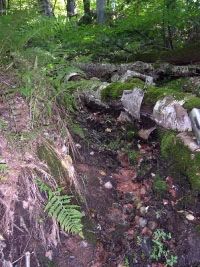
Photo by B. Delaney
St. Croix Seeps contains a four-mile stretch of river and is one of the most diverse places along the St. Croix National Scenic Riverway for rare species. Here the terrace is very near the river and numerous seeps and spring runs emanate from the lower slopes of the steep, west-facing bluff. This area supports a high-quality black ash seepage swamp with yellow birch and red maple. Dominant ground layer species include skunk cabbage, broom-like sedge, jewelweed, ostrich fern, eastern willow-herb, fowl manna grass, marsh bluegrass, and swamp aster.
The southwest flank of the river bluff is forested with red pine and old-growth red oak and white pine. Below is a large flowing seepage run with a shady overstory of old-growth sugar maple and eastern hop-hornbeam. Understory species include American golden saxifrage, lady fern, and Pennsylvania sedge. These small, specialized habitats support large populations of rare plant species. Common trees within the area include basswood, green ash, bitternut hickory, and hackberry. Associate herbaceous species are Virginia water-leaf, cut-leaved coneflower, rosy sedge, wild geranium, black snakeroot, and Jack-in-the-pulpit. This area of the St. Croix is also an important habitat for numerous rare dragonfly and fish species. St. Croix Seeps is owned by the National Park Service and was designated a State Natural Area in 2002.
Very few State Natural Areas have public facilities, but nearly all are open for a variety of recreational activities as indicated below. Generally, there are no picnic areas, restrooms, or other developments. Parking lots or designated parking areas are noted on individual SNA pages and maps. If a developed trail is present, it will normally be noted on the SNA map and/or under the Maps tab. A compass and topographic map or a GPS unit are useful tools for exploring larger, isolated SNAs.
The good majority of SNAs are isolated and have few or no facilities. Some SNAs have vehicle access lanes or parking lots, but their accessibility may vary depending on weather conditions. Parking lots and lanes are not plowed during winter. Hiking trails may be nonexistent or consist of undeveloped footpaths. A GPS unit or compass and a detailed topographic map are useful tools for exploring larger SNAs.
Non-DNR lands
Entrance fees: For non-DNR-owned SNAs, we are unaware of any vehicle or admission fees. However, please contact the landowner for more information.
Hunting and trapping
Other activities
Other allowable activities such as - but not limited to camping, geocaching and bicycling are determined by the landowner. Please contact them directly or visit their websites for details.
Location
Within the St. Croix National Scenic Riverway, Burnett County. T37N-R20W, Sections 8, 17, 20, 29, 30. 350 acres.
Driving directions
From the intersection of County O and Highway 48 in Trade Lake, go west on O 13.7 miles to a parking area north of the road. The Sunrise Ferry hiking trail provides access to the site.
The DNR's state natural areas program is comprised of lands owned by the state, private conservation organizations, municipalities, other governmental agencies, educational institutions and private individuals. While the majority of SNAs are open to the public, access may vary according to individual ownership policies. Public use restrictions may apply due to public safety, or to protect endangered or threatened species or unique natural features. Lands may be temporarily closed due to specific management activities.
Users are encouraged to contact the landowner for more specific details. The data shown on these maps have been obtained from various sources, and are of varying age, reliability, and resolution. The data may contain errors or omissions and should not be interpreted as a legal representation of legal ownership boundaries. To create your custom map where you can zoom to a specific location, please use the DNR's Mapping Application.
St. Croix Seeps is owned by: National Park Service