Squirrel River Pines
No. 244
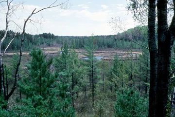
Photo by Eric Epstein
Squirrel River Pines features a fine example of a northern dry-mesic forest situated on a narrow, sandy peninsula running northeasterly towards the Squirrel River. The forest is dominated by a stand of old, large red pines in the 16" to 24" diameter size class, with a few trees up to 30" in diameter. White pine makes up roughly 10% of the canopy but constitutes most of the reproduction. Charring on some of the oldest stumps and snags indicates a fire history and probable origin of this stand. The shrub layer is moderately dense, with beaked hazel and Amelanchier species dominant.
The herbaceous and low shrub layer is primarily composed of wintergreen, early low blueberry, velvet-leaf blueberry, and Canada mayflower. Other species include pipsissewa, three-leaved goldthread, round-lobed hepatica, twinflower, and one-sided shinleaf. Surrounding the uplands is a large wetland complex of northern wet forest, northern sedge meadow, and alder thicket associated with the Squirrel River, a slow, warm, hard-water river that flows through the site. The natural area supports a diversity of animals, including characteristic species such as pine warbler, red squirrel, and red-breasted nuthatch. Bald eagles have used the pines as a nesting site. Squirrel River Pines is owned by the DNR and was designated a State Natural Area in 1991.
Very few State Natural Areas have public facilities, but nearly all are open for a variety of recreational activities as indicated below. Generally, there are no picnic areas, restrooms, or other developments. Parking lots or designated parking areas are noted on individual SNA pages and maps. If a developed trail is present, it will normally be noted on the SNA map and/or under the Maps tab. A compass and topographic map or a GPS unit are useful tools for exploring larger, isolated SNAs.
The good majority of SNAs are isolated and have few or no facilities. Some SNAs have vehicle access lanes or parking lots, but their accessibility may vary depending on weather conditions. Parking lots and lanes are not plowed during winter. Hiking trails may be nonexistent or consist of undeveloped footpaths. A GPS unit or compass and a detailed topographic map are useful tools for exploring larger SNAs.
Entrance fees: Except for Parfrey's Glen, the Cambrian Outlook in the Dells of the Wisconsin River, SNAs within State Parks and some within State Forests, all other DNR-owned SNAs do not have any admission fees. For more information, see Wis. Admin. Code NR 45 [exit DNR]. For non-DNR-owned SNAs, we are unaware of any vehicle or admission fees. However, please contact the landowner for more information.
Allowable activities: DNR-owned land
The activities listed below are generally allowed on all DNR-owned SNA lands. Exceptions to this list of public uses, such as SNAs closed to hunting, are noted above and posted with signs on the property site.
- Hiking
- Fishing
- Cross country skiing
- Hunting
- Trapping
- Scientific research (permit required [PDF])
- Outdoor education
- Wild edibles (What is this?)
- Pets (Rules)
- Wildlife viewing
Prohibited activities: all SNAs
Although a handful of sites allow activities like primitive camping (e.g. Lower Chippewa River on sand bars) or horseback riding (e.g. S. Kettle Moraine), the activities listed below are generally prohibited on DNR-owned SNAs.
- Camping and campfires
- Collecting of animals (other than legally harvested species), non-edible fungi, rocks, minerals, fossils, archaeological artifacts, soil, downed wood, or any other natural material, alive or dead.
- Collecting for scientific research requires a permit issued by the DNR
- Collecting of plants including seeds, roots or other non-edible parts of herbaceous plants such as wildflowers or grasses
- Drones: Flying-related activities, including the use of drones, hang-gliders and model airplanes, are prohibited. Permission may be issued by the SNA Program for the use of drones for educational or research purposes
- Geocaching
- Horseback riding
- Rock climbing
- Vehicles, including bicycles, ATVs, aircraft, and snowmobiles except on trails and roadways designated for their use.
For rules governing state-owned SNAs and other state lands, please consult Chapter NR 45 Wis. Admin. Code [exit DNR].
Location
Oneida County. T39N-R5E, Sections 20, 21, 26, 27, 29, 34, 35, 36. 1,363 acres.
Driving directions
To reach the largest stand of pines in the northern unit: from the junction of U.S. Highway 51 and State Highway 70 in Woodruff, go west on Highway 70 about 6.9 miles to Squirrel Lake Road, then south 4.5 miles to Scotchman Lake Road, then east 1.3 miles. The River Run cross-country ski trail operated by Minocqua Winter Park intersects Scotchman Lake Road at this point. Park along the road and walk or ski north (not east) along the trail 0.8 miles to the southern boundary of the natural area. Proceed north another 0.25 miles to reach the pines. The southern unit is best accessed by water via the Squirrel River.
The DNR's state natural areas program is comprised of lands owned by the state, private conservation organizations, municipalities, other governmental agencies, educational institutions and private individuals. While the majority of SNAs are open to the public, access may vary according to individual ownership policies. Public use restrictions may apply due to public safety, or to protect endangered or threatened species or unique natural features. Lands may be temporarily closed due to specific management activities.
Users are encouraged to contact the landowner for more specific details. The data shown on these maps have been obtained from various sources, and are of varying age, reliability, and resolution. The data may contain errors or omissions and should not be interpreted as a legal representation of legal ownership boundaries. To create your custom map where you can zoom to a specific location, please use the DNR's Mapping Application.
Squirrel River Pines is owned by: Wisconsin DNR