Spring Green Preserve
No. 102
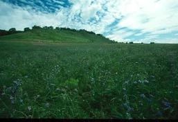
Photo by Thomas A. Meyer/DNR
Spring Green Preserve, known as the 'Wisconsin Desert', features a rolling sand prairie on an old Wisconsin River terrace and harbors unique flora and fauna that are adapted to the hot, droughty environment. The dry sandy soils contain many desert-like plants such as false heather, three-awn grass, and prickly pear cactus. Nearly 40 species of annuals and biennials thrive here, a high number for a prairie, including plains snake-cotton, Venus'-looking-glass, and dwarf dandelion. Several sand blows, with shifting dunes and open sand, are scattered throughout.
Bird life is diverse and includes large numbers of rare open country birds such as the dickcissel. The invertebrates, however, are the most unusual of the Spring Green fauna. Several of the spiders and insects are not known from any other site in Wisconsin. Of special interest are the black widow and several wolf spiders, five species of cicada, eight species of tiger beetles, and predatory wasps. A large pocket gopher population has created patches of open ground where short-lived plants grow. Spring Green Preserve is owned by The Nature Conservancy and was designated a State Natural Area in 1972.
Very few State Natural Areas have public facilities, but nearly all are open for a variety of recreational activities as indicated below. Generally, there are no picnic areas, restrooms, or other developments. Parking lots or designated parking areas are noted on individual SNA pages and maps. If a developed trail is present, it will normally be noted on the SNA map and/or under the Maps tab. A compass and topographic map or a GPS unit are useful tools for exploring larger, isolated SNAs.
The good majority of SNAs are isolated and have few or no facilities. Some SNAs have vehicle access lanes or parking lots, but their accessibility may vary depending on weather conditions. Parking lots and lanes are not plowed during winter. Hiking trails may be nonexistent or consist of undeveloped footpaths. A GPS unit or compass and a detailed topographic map are useful tools for exploring larger SNAs.
Hunting and trapping
For hunting opportunities on Nature Conservancy land, visit The Nature Conservancy's Deer Management [exit DNR].
Allowable activities: DNR-owned land
The activities listed below are generally allowed on all DNR-owned SNA lands. Exceptions to this list of public uses, such as SNAs closed to hunting, are noted above and posted with signs on the property site.
- Hiking
- Fishing
- Cross country skiing
- Hunting
- Trapping
- Scientific research (permit required [PDF])
- Outdoor education
- Wild edibles (What is this?)
- Pets (Rules)
- Wildlife viewing
Prohibited activities: all SNAs
- Camping and campfires
- Collecting of animals (other than legally harvested species), non-edible fungi, rocks, minerals, fossils, archaeological artifacts, soil, downed wood, or any other natural material, alive or dead.
- Collecting for scientific research requires a permit issued by the DNR
- Collecting of plants including seeds, roots or other non-edible parts of herbaceous plants such as wildflowers or grasses
- Geocaching
- Horseback riding
- Rock climbing
- Vehicles, including bicycles, ATVs, aircraft, and snowmobiles except on trails and roadways designated for their use.
For rules governing state-owned SNAs and other state lands, please consult Chapter NR 45 Wis. Admin. Code [exit DNR].
Location
Sauk County. T8N-R4E, Sections 5, 6. T9N-R3E, Sections 35, 36. T9N-R4E, Sections 31, 32. 1,104 acres.
Driving directions
From the intersection of Highways 14 and 23 north of Spring Green, go north on 23 for 0.5 miles, then east on Jones Road for 0.75 miles (just past Fire #E5196A), then north on Angelo Lane to a parking area. Trails lead through the site.
The DNR's state natural areas program is comprised of lands owned by the state, private conservation organizations, municipalities, other governmental agencies, educational institutions and private individuals. While the majority of SNAs are open to the public, access may vary according to individual ownership policies. Public use restrictions may apply due to public safety, or to protect endangered or threatened species or unique natural features. Lands may be temporarily closed due to specific management activities.
Users are encouraged to contact the landowner for more specific details. The data shown on these maps have been obtained from various sources, and are of varying age, reliability, and resolution. The data may contain errors or omissions and should not be interpreted as a legal representation of legal ownership boundaries. To create your custom map where you can zoom to a specific location, please use the DNR's Mapping Application.
Spring Green Preserve is owned by: The Nature Conservancy