Spring Brook Drumlins
No. 458
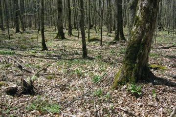
Photo by U.S. Forest Service
Spring Brook Drumlins represents the largest tract of closed canopy mesic hardwood forest in the National Forest outside of the Penokee Range. Located on drumline ground moraine with a silt loam surface, the forest is predominantly rich upland sugar maple-basswood forest with scattered pockets of hemlock and lowland black spruce-tamarack. Other mesic forest canopy trees include white ash, black ash, and occasionally yellow birch and red oak. Ironwood and sugar maple poles and saplings make up the majority of the midstory. The shrub layer is poorly developed and consists primarily of gooseberry and leatherwood. The forest supports a diverse forb population including several spring ephemerals uncommon in the Forest.
Characteristic species on drumlin ridges include spring beauty, dwarf ginseng, downy yellow violet, rattlesnake fern, wood anemone, large-flowered trillium, and toothwort. Richer, moister inclusions along drainage swales, side slopes, and shallow depressions support such species as Dutchman's-breeches, bloodroot, wild leek, blue cohosh, wild ginger, maidenhair fern, and lady fern. The best areas have a mature stand structure with large diameter trees with broad canopies and an open park-like understory. Den trees are common although snags and coarse woody debris are mostly absent, except for dead elm. Hemlock-dominated wet-mesic forest occupies perched wetland areas while the black spruce-tamarack bogs and cedar swamps are found in inter-drumlin areas.
On level and somewhat poorly drained drumline ground moraine is a rich, northern hardwood swamp forest dominated by 16-18 inch black ash with red maple and yellow birch. American elm snags and downed logs killed from Dutch elm disease are common throughout. The herb layer is diverse with spring ephemerals in wet-mesic areas and cinnamon fern, jewelweed, marsh marigold, horsetail and sedges in seasonally inundated areas.
Another key feature is Spring Brook Meadows, a high-quality sedge meadow dominated by blue-joint grass and sedges along the border of Spring Brook. Included is a small stand of relatively old-growth northern white cedar. Perhaps the attribute that best typifies this site is its expansive size. Few places in the Forest allow one to walk for several miles through unbroken canopy cover in an older, maturing hardwood forest. Spring Brook Drumlins is owned by the US Forest Service and was designated a State Natural Area in 2007.
Very few State Natural Areas have public facilities, but nearly all are open for a variety of recreational activities as indicated below. Generally, there are no picnic areas, restrooms, or other developments. Parking lots or designated parking areas are noted on individual SNA pages and maps. If a developed trail is present, it will normally be noted on the SNA map and/or under the Maps tab. A compass and topographic map or a GPS unit are useful tools for exploring larger, isolated SNAs.
The good majority of SNAs are isolated and have few or no facilities. Some SNAs have vehicle access lanes or parking lots, but their accessibility may vary depending on weather conditions. Parking lots and lanes are not plowed during winter. Hiking trails may be nonexistent or consist of undeveloped footpaths. A GPS unit or compass and a detailed topographic map are useful tools for exploring larger SNAs.
Non-DNR lands
Entrance fees: For non-DNR-owned SNAs, we are unaware of any vehicle or admission fees. However, please contact the landowner for more information.
Hunting and trapping
Other activities
Other allowable activities such as - but not limited to camping, geocaching and bicycling are determined by the landowner. Please contact them directly or visit their websites for details.
Location
Within the Chequamegon-Nicolet National Forest. Ashland and Sawyer Counties. T40N-R3W, Sec. 1-4, 10, 11, 12; T41N-R3W, Sec. 25, 26, 27, 33-36. 3,162 acres.
Driving directions
The site is located 12 miles west of Park Falls, WI. Access to the site is via Forest Roads 161 and 163. From Park Falls, go west on County E for 11 miles, then north on FR 161 for 5 miles. The site lies north of the road.
The DNR's state natural areas program is comprised of lands owned by the state, private conservation organizations, municipalities, other governmental agencies, educational institutions and private individuals. While the majority of SNAs are open to the public, access may vary according to individual ownership policies. Public use restrictions may apply due to public safety, or to protect endangered or threatened species or unique natural features. Lands may be temporarily closed due to specific management activities.
Users are encouraged to contact the landowner for more specific details. The data shown on these maps have been obtained from various sources, and are of varying age, reliability, and resolution. The data may contain errors or omissions and should not be interpreted as a legal representation of legal ownership boundaries. To create your custom map where you can zoom to a specific location, please use the DNR's Mapping Application.
Spring Brook Drumlins is owned by: US Forest Service