Spread Eagle Barrens
No. 290
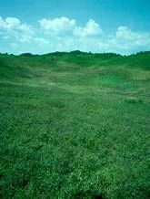
Photo by Thomas A. Meyer/DNR
Spread Eagle Barrens protects an extensive landscape of bracken grassland and barrens dominated by scattered jack pine, red pine, scrub oak, and quaking aspen. The sandy soils support an understory of sedges, bracken and sweet fern, slender wheatgrass, muhly grass, poverty oats, hazelnut, serviceberry, blueberry, and willows. A mosaic of six different communities, the natural area was established to protect the Pine Barrens community and associated flora and fauna that require large expanses of open vegetation. Frost pockets, and treeless depressions where frost may occur at any time of year, punctuate the landscape. Sedges, lichens, and other plant species have adapted to this harsh microclimate and can dominate these low-lying areas. In contrast, bracken fern, Jack pines and other small trees dominate the uplands where they are interspersed with grasses. Many rare or declining species of large open landscapes live here. Birds include northern raven, winter wren, eastern bluebird, warbling vireo, Nashville, chestnut-sided, pine, and mourning warblers, clay-colored sparrow, common nighthawk, eastern towhee, and Brewer's blackbird. Mammals include black bears, fishers, badgers, coyotes, red foxes and white-tailed deer. The lower reaches of the Pine River, a designated Wild River, traverse the site and the Menominee River forms the property’s eastern boundary. Management activities such as timber harvest and prescribed burning help maintain the open landscape. Spread Eagle Barrens is owned by the DNR and WE Energies and was designated a State Natural Area in 1995.
Very few State Natural Areas have public facilities, but nearly all are open for a variety of recreational activities as indicated below. Generally, there are no picnic areas, restrooms, or other developments. Parking lots or designated parking areas are noted on individual SNA pages and maps. If a developed trail is present, it will normally be noted on the SNA map and/or under the Maps tab. A compass and topographic map or a GPS unit are useful tools for exploring larger, isolated SNAs.
The good majority of SNAs are isolated and have few or no facilities. Some SNAs have vehicle access lanes or parking lots, but their accessibility may vary depending on weather conditions. Parking lots and lanes are not plowed during winter. Hiking trails may be nonexistent or consist of undeveloped footpaths. A GPS unit or compass and a detailed topographic map are useful tools for exploring larger SNAs.
Entrance fees: Except for Parfrey's Glen, the Cambrian Outlook in the Dells of the Wisconsin River, SNAs within State Parks, and some within State Forests, all other DNR-owned SNAs do not have any admission fees. For more information, see Wis. Admin. Code NR 45 [exit DNR]. For non-DNR-owned SNAs, we are unaware of any vehicle or admission fees. However, please contact the landowner for more information.
Hunting and Trapping
Allowable activities: DNR-owned land
The activities listed below are generally allowed on all DNR-owned SNA lands. Exceptions to this list of public uses, such as SNAs closed to hunting, are noted above and posted with signs on the property site.
- Hiking
- Fishing
- Cross country skiing
- Hunting
- Trapping
- Scientific research (permit required [PDF])
- Outdoor education
- Wild edibles (What is this?)
- Pets (Rules)
- Wildlife viewing
Prohibited activities: all SNAs
Although a handful of sites allow activities like primitive camping (e.g. Lower Chippewa River on sand bars) or horseback riding (e.g. S. Kettle Moraine), the activities listed below are generally prohibited on DNR-owned SNAs.
- Camping and campfires
- Collecting of animals (other than legally harvested species), non-edible fungi, rocks, minerals, fossils, archaeological artifacts, soil, downed wood, or any other natural material, alive or dead.
- Collecting for scientific research requires a permit issued by the DNR
- Collecting of plants including seeds, roots or other non-edible parts of herbaceous plants such as wildflowers or grasses
- Drones: Flying-related activities, including the use of drones, hang-gliders and model airplanes, are prohibited. Permission may be issued by the SNA Program for the use of drones for educational or research purposes
- Geocaching
- Horseback riding
- Rock climbing
- Vehicles, including bicycles, ATVs, aircraft, and snowmobiles except on trails and roadways designated for their use.
For rules governing state-owned SNAs and other state lands, please consult Chapter NR 45 Wis. Admin. Code [exit DNR].
Location
Florence County. T39N-R18E, Sections 12, 13, 14, 24. T39N-R19E, Sections 3, 4, 6-10, 15-22, 28-33. 7,155 acres.
Driving directions
Four parking areas: 1) From the intersection of U.S. 2 and Old Highway 69 Road in Spread Eagle, go south and west of Old 69 Road for 0.5 miles, then south on W. Ellwood Lake Road about 1.2 miles to a parking area. 2) From the intersection of U.S. 2 and Old Highway 69, go south and west on Old 69 for 0.85 miles, then south on Lake Anna Road for 0.8 miles, then south on Overlook Road for 1 mile to the parking area. 3) From the intersection of U.S. 2 and East Ellwood Lake Road in Spread Eagle, go south on East Ellwood Lake Road 2.5 miles, then southeast on Menominee River Road 1.3 miles to a parking area north of the road. 4) From the intersection of U.S. 2 and County N in Florence, go south on County N for 8 miles, then east on Roach Fire Lane Road for about 2.9 miles to a parking area on the left.
The DNR's state natural areas program is comprised of lands owned by the state, private conservation organizations, municipalities, other governmental agencies, educational institutions and private individuals. While the majority of SNAs are open to the public, access may vary according to individual ownership policies. Public use restrictions may apply due to public safety, or to protect endangered or threatened species or unique natural features. Lands may be temporarily closed due to specific management activities.
Users are encouraged to contact the landowner for more specific details. The data shown on these maps have been obtained from various sources, and are of varying age, reliability, and resolution. The data may contain errors or omissions and should not be interpreted as a legal representation of legal ownership boundaries. To create your custom map where you can zoom to a specific location, please use the DNR's Mapping Application.
Spread Eagle Barrens is owned by: Wisconsin DNR and Private