South Branch Beech Grove
No. 498
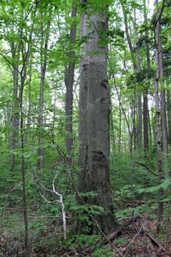
Photo by U.S. Forest Service
The core of South Branch Beech Grove centers on a mature hardwood forest of beech and sugar maple bordering Menominee County and the Menominee Indian Reservation. This excellent quality stand contains large beech, basswood, sugar maple and butternut with the largest trees measuring 24-28 inches in diameter. Sugar maple and beech are reproducing successfully. The canopy is composed of roughly 50% sugar maple, and 30% beech, with lesser amounts of hemlock, yellow birch, basswood, red oak, red maple, paper birch, big-tooth aspen, and bitternut hickory. The uncommon butternut (Juglans cinerea) is also present. The stand has a history of timber harvest and stand improvements although recent disturbance has been minimal.
Structurally the stand includes pockets of mature timber characterized by large trees intermingled with nondescript areas that appear to be dominated by even-aged pole-size or small saw timber trees. The stands also have good old-growth characteristics including large coarse woody debris, snags, and good canopy gaps from the natural loss of mature trees. These gaps are filled in with beech seedlings and saplings. The shrub layer is patchy and generally poorly developed where the canopy is closed and little light penetrates to the forest floor.
Common species include maple-leaved viburnum, beaked hazelnut, American fly honeysuckle, and mountain maple. The ground layer is characterized by herbs such as Canada mayflower, yellow blue-bead lily, wild sarsaparilla, rosy twisted stalk, blue cohosh, and hepaticas. Rare, uncommon, and notable plants include little goblin moonwort, blunt-lobed grape fern, Indian cucumber-root, butternut, Canada yew, lesser purple fringed orchid, cut-leaved grape fern, least moonwort, and white bear sedge. This site is part of a larger area that supports the highest concentration of a state-threatened bird in the Forest. South Branch Beech Grove is owned by the U.S. Forest Service and was designated a State Natural Area in 2007. This site is also recognized by the Forest Service as an established Research Natural Area.
Very few State Natural Areas have public facilities, but nearly all are open for a variety of recreational activities as indicated below. Generally, there are no picnic areas, restrooms, or other developments. Parking lots or designated parking areas are noted on individual SNA pages and maps. If a developed trail is present, it will normally be noted on the SNA map and/or under the Maps tab. A compass and topographic map or a GPS unit are useful tools for exploring larger, isolated SNAs.
The good majority of SNAs are isolated and have few or no facilities. Some SNAs have vehicle access lanes or parking lots, but their accessibility may vary depending on weather conditions. Parking lots and lanes are not plowed during winter. Hiking trails may be nonexistent or consist of undeveloped footpaths. A GPS unit or compass and a detailed topographic map are useful tools for exploring larger SNAs.
Non-DNR lands
Entrance fees: For non-DNR-owned SNAs, we are unaware of any vehicle or admission fees. However, please contact the landowner for more information.
Hunting and trapping
Other activities
Other allowable activities such as - but not limited to camping, geocaching and bicycling are determined by the landowner. Please contact them directly or visit their websites for details.
Location
Within the Chequamegon-Nicolet National Forest, Oconto County. T31N-15E, Sections 26, 27, 34, 35, 36. 779 acres.
Driving directions
Access is provided by County W from the north and west and FR 2856 (also known as Old Shingle Mill Road) is located about 0.15 miles east of the bridge over the Second South Branch Oconto River. Proceed south on FR 2856 for about 1.7 miles, staying on the better-traveled gravel road (rather than taking forks that appear less traveled) to the end of the graveled portion. Park and walk south along the road until the north boundary of the Menominee Indian Reservation is reached. The reservation boundary is marked with blazes, stakes, and signs. The site lies on the uplands to the east, adjacent to the north boundary of the reservation.
The DNR's state natural areas program is comprised of lands owned by the state, private conservation organizations, municipalities, other governmental agencies, educational institutions and private individuals. While the majority of SNAs are open to the public, access may vary according to individual ownership policies. Public use restrictions may apply due to public safety, or to protect endangered or threatened species or unique natural features. Lands may be temporarily closed due to specific management activities.
Users are encouraged to contact the landowner for more specific details. The data shown on these maps have been obtained from various sources, and are of varying age, reliability, and resolution. The data may contain errors or omissions and should not be interpreted as a legal representation of legal ownership boundaries. To create your custom map where you can zoom to a specific location, please use the DNR's Mapping Application.
South Branch Beech Grove is owned by: US Forest Service