Snow Falls Creek
No. 309
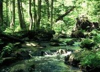
Photo by USFS staff
Snow Falls Creek is a high gradient, boulder-strewn trout stream originating in two large spring ponds (Sullivan Springs and Hickey Springs) to the north and joining the North Branch of the Oconto River south of the natural area. The creek is bordered by white cedar, balsam fir, and black ash. Tall, scattered white pines add to the forest structure. The ravines and uplands west of Snow Falls Creek support an exceptional forest composed primarily of hemlock, sugar maple, yellow birch, basswood, red oak, and beech, here at its northwest limits in the state. The shrub layer is poorly developed throughout with prevalent species of mountain maple, beaked hazelnut, leatherwood, witch hazel, and alternate-leaved dogwood.
Characteristic species of the moderately rich but sparse herb layer are wild sarsaparilla, Canada mayflower, big-leaved aster, lady fern, and club-mosses. Noteworthy herbs include Indian cucumber root, early coral root, and spotted coral root. The rolling morainal uplands surrounding the creek and mature hemlock hardwoods are forested with even-aged stands of pole-sized paper birch, trembling aspen, and sugar maple. Although the forest has a history of selective cutting, no recent timber harvest has occurred and the stand remains relatively intact. Resident bird species include black-throated green and blackburnian warblers, ovenbird, solitary vireo, wood thrush, hermit thrush, veery, and least flycatcher. Snow Falls Creek is owned by the U.S. Forest Service and was designated a State Natural Area in 1996.
Very few State Natural Areas have public facilities, but nearly all are open for a variety of recreational activities as indicated below. Generally, there are no picnic areas, restrooms, or other developments. Parking lots or designated parking areas are noted on individual SNA pages and maps. If a developed trail is present, it will normally be noted on the SNA map and/or under the Maps tab. A compass and topographic map or a GPS unit are useful tools for exploring larger, isolated SNAs.
The good majority of SNAs are isolated and have few or no facilities. Some SNAs have vehicle access lanes or parking lots, but their accessibility may vary depending on weather conditions. Parking lots and lanes are not plowed during winter. Hiking trails may be nonexistent or consist of undeveloped footpaths. A GPS unit or compass and a detailed topographic map are useful tools for exploring larger SNAs.
Non-DNR lands
Entrance fees: For non-DNR-owned SNAs, we are unaware of any vehicle or admission fees. However, please contact the landowner for more information.
Hunting and trapping
Other activities
Other allowable activities such as - but not limited to camping, geocaching and bicycling are determined by the landowner. Please contact them directly or visit their websites for details.
Location
Within the Chequamegon-Nicolet National Forest, Oconto County. T32N-R16E, Sections 1, 12. 153 acres.
Driving directions
From the intersection of State Highway 32 and County Highway F in Lakewood, go east on F 2.0 miles, then east and south on Old 32 (FR 2106) 2.4 miles, then east on FR 2070 0.7 miles, then northeast on FR 2070A 0.7 miles to the northwest boundary. Walk east 0.3 miles into the site.
The DNR's state natural areas program is comprised of lands owned by the state, private conservation organizations, municipalities, other governmental agencies, educational institutions and private individuals. While the majority of SNAs are open to the public, access may vary according to individual ownership policies. Public use restrictions may apply due to public safety, or to protect endangered or threatened species or unique natural features. Lands may be temporarily closed due to specific management activities.
Users are encouraged to contact the landowner for more specific details. The data shown on these maps have been obtained from various sources, and are of varying age, reliability, and resolution. The data may contain errors or omissions and should not be interpreted as a legal representation of legal ownership boundaries. To create your custom map where you can zoom to a specific location, please use the DNR's Mapping Application.
Snow Falls Creek is owned by: U.S. Forest Service