Snow Bottom
No. 262
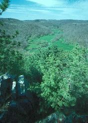
Photo by Thomas A. Meyer/DNR
Snow Bottom State Natural Area lies in the very heart of a diverse and spectacular Driftless Area landscape. It encompasses the most significant pine relicts in Wisconsin, as well as many other important and uncommon native plant communities including fen and springs, southern dry-mesic forest and oak woodland, riparian areas, and geological features. Located on the scattered sandstone outcrops are the pine relicts -- isolated stands of white and red pine with occasional jack pine. Understory plant species include numerous evergreen and ericaceous species such as blueberry, huckleberry, pipsissewa, and partridgeberry.
Red oak dominates the dry-mesic forest with white oak, sugar maple, basswood, and red maple and the herbaceous understory is diverse with jack-in-the-pulpit, enchanter's nightshade, large-flowered bellwort, interrupted fern, lady fern, tick-trefoils, and hog peanut. To the detriment of the oaks, more mesophytic, shade-tolerant tree species are becoming established under current management practices and fire suppression. Also present is a diverse wetland of calcareous fen and springs that support numerous calciphitic plants such as shrubby cinquefoil, grass-of-Parnassus, Kalm's lobelia, Ohio goldenrod, boneset, and swamp thistle. The Blue River flows north off the Military Ridge through Snow Bottom to the Wisconsin River. The river is a classic, cold water Driftless Area stream with a noteworthy trout fishery. Snow Bottom is owned jointly by the DNR and private landowners and was designated a State Natural Area in 1992.
Very few State Natural Areas have public facilities, but nearly all are open for a variety of recreational activities as indicated below. Generally, there are no picnic areas, restrooms, or other developments. Parking lots or designated parking areas are noted on individual SNA pages and maps. If a developed trail is present, it will normally be noted on the SNA map and/or under the Maps tab. A compass and topographic map or a GPS unit are useful tools for exploring larger, isolated SNAs.
The good majority of SNAs are isolated and have few or no facilities. Some SNAs have vehicle access lanes or parking lots, but their accessibility may vary depending on weather conditions. Parking lots and lanes are not plowed during winter. Hiking trails may be nonexistent or consist of undeveloped footpaths. A GPS unit or compass and a detailed topographic map are useful tools for exploring larger SNAs.
Hunting and trapping
Allowable activities: DNR-owned land
The activities listed below are generally allowed on all DNR-owned SNA lands. Exceptions to this list of public uses, such as SNAs closed to hunting, are noted above and posted with signs on the property site.
- Hiking
- Fishing
- Cross country skiing
- Hunting
- Trapping
- Scientific research (permit required [PDF])
- Outdoor education
- Wild edibles (What is this?)
- Pets (Rules)
- Wildlife viewing
Prohibited activities: all SNAs
- Camping and campfires
- Collecting of animals (other than legally harvested species), non-edible fungi, rocks, minerals, fossils, archaeological artifacts, soil, downed wood, or any other natural material, alive or dead.
- Collecting for scientific research requires a permit issued by the DNR
- Collecting of plants including seeds, roots or other non-edible parts of herbaceous plants such as wildflowers or grasses
- Geocaching
- Horseback riding
- Rock climbing
- Vehicles, including bicycles, ATVs, aircraft, and snowmobiles except on trails and roadways designated for their use.
For rules governing state-owned SNAs and other state lands, please consult Chapter NR 45 Wis. Admin. Code [exit DNR].
Location
Grant County. T7N-R1W, Sections 27, 28, 30, 34, 35. 676 acres.
Driving directions
From the intersection of State Highway 18 and County G west of Montfort, go north on G for 4.6 miles, then east on Bowers Road for 1.6 miles to a small parking area just west of the Blue River. Walk north into the site. To access the western SNA parcel, from the intersection of County Q and G (located east of Castle Rock), go west on County Q for 1.6 miles, then north and west on Cedar Rock Road for about 0.4 miles. Walk north into the SNA. A paddle through Snow Bottom on the Blue River is rewarding, but possible only with small kayaks during periods of adequate river flow, usually in spring. The twisty, 5.5-mile section of river from the Bowers Road parking lot downstream to Shemak Road is wild, offering wonderful Driftless Area scenery and excellent trout fishing.
The DNR's state natural areas program is comprised of lands owned by the state, private conservation organizations, municipalities, other governmental agencies, educational institutions and private individuals. While the majority of SNAs are open to the public, access may vary according to individual ownership policies. Public use restrictions may apply due to public safety, or to protect endangered or threatened species or unique natural features. Lands may be temporarily closed due to specific management activities.
Users are encouraged to contact the landowner for more specific details. The data shown on these maps have been obtained from various sources, and are of varying age, reliability, and resolution. The data may contain errors or omissions and should not be interpreted as a legal representation of legal ownership boundaries. To create your custom map where you can zoom to a specific location, please use the DNR's Mapping Application.
Snow Bottom is owned by: Private and the Wisconsin DNR