Snoose Creek
No. 431
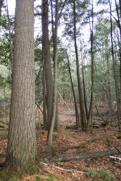
Photo by Steven Spickerman, U.S. Forest Service
One of the largest sites identified on the Glidden Drumlin Landtype, Snoose Creek features a complex of natural communities located along the East Fork of the Chippewa River. Of note is the presence of drumlin-shaped uplands dominated by second-growth poles to mature northern hardwoods, with significant inclusions of hemlock-dominated forest present throughout the site. These inclusions include residual old-growth hemlock and yellow birch located within upland northern hardwood stands and extensive areas of second-growth hemlock with super-canopy white pine and upland cedar in transitional areas along swamp margins and woodland ephemeral ponds.
The presence of super-canopy white pine as a component in several mesic northern hardwood stands adds to this site's overall conservation value. Associated communities include large tracts of black spruce-tamarack bog, black ash swamp, and lowland mixed conifer swamps with significant stands of white cedar located within inter-drumlin areas. These wetland communities give rise to two small streams including Snoose Creek, a tributary to the East Fork of the Chippewa River. Snoose Creek originates at Snoose Lake in Ashland County and then flows south into the East Fork of the Chippewa River below Blaisedell Lake. It is a warm water drainage stream having a fish population of minnows with a few small panfish present. The bottom is predominantly muck with unstable sandy stretches. The river itself, which forms the western boundary of this site, includes several class two rapids with numerous Precambrian rock outcrops along this reach.
Forested stands dominated by long-lived conifers border most of the river bank along this segment. Most of this site remains undeveloped with very few improved road corridors, thereby providing important extensive forest habitat. Due to aspen pulpwood production and game habitat development, few tracts of this scale remain on this land type which still retains interior forest conditions. Snoose Creek is owned by the US Forest Service and was designated a State Natural Area in 2007.
Very few State Natural Areas have public facilities, but nearly all are open for a variety of recreational activities as indicated below. Generally, there are no picnic areas, restrooms, or other developments. Parking lots or designated parking areas are noted on individual SNA pages and maps. If a developed trail is present, it will normally be noted on the SNA map and/or under the Maps tab. A compass and topographic map or a GPS unit are useful tools for exploring larger, isolated SNAs.
The good majority of SNAs are isolated and have few or no facilities. Some SNAs have vehicle access lanes or parking lots, but their accessibility may vary depending on weather conditions. Parking lots and lanes are not plowed during winter. Hiking trails may be nonexistent or consist of undeveloped footpaths. A GPS unit or compass and a detailed topographic map are useful tools for exploring larger SNAs.
Non-DNR lands
Entrance fees: For non-DNR-owned SNAs, we are unaware of any vehicle or admission fees. However, please contact the landowner for more information.
Hunting and trapping
Other activities
Other allowable activities such as - but not limited to camping, geocaching and bicycling are determined by the landowner. Please contact them directly or visit their websites for details.
Location
Within the Chequamegon-Nicolet National Forest, Ashland and Sawyer Counties. T40N-R4W Sections 5, 6, 7, 8. T41N-R4W Sections 32. 1,099 acres.
Driving directions
From the intersection of Highways 70 and GG in Loretta, go north on GG for approximately 8 miles, then southwest on FR 172 2.5 miles into the site.
The DNR's state natural areas program is comprised of lands owned by the state, private conservation organizations, municipalities, other governmental agencies, educational institutions and private individuals. While the majority of SNAs are open to the public, access may vary according to individual ownership policies. Public use restrictions may apply due to public safety, or to protect endangered or threatened species or unique natural features. Lands may be temporarily closed due to specific management activities.
Users are encouraged to contact the landowner for more specific details. The data shown on these maps have been obtained from various sources, and are of varying age, reliability, and resolution. The data may contain errors or omissions and should not be interpreted as a legal representation of legal ownership boundaries. To create your custom map where you can zoom to a specific location, please use the DNR's Mapping Application.
Snoose Creek is owned by: U.S. Forest Service