Smith-Reiner Drumlin Prairie
No. 654
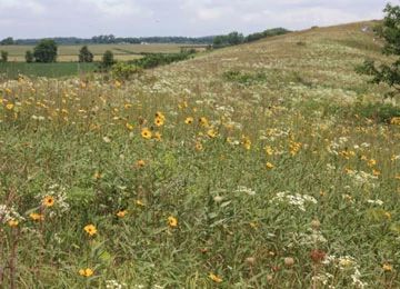
Photo by Rich Henderson
Smith-Reiner Drumlin Prairie contains 13 acres of upland prairie remnants with 106 native plant species that are on two northeast to southwest-oriented glacially sculpted ridges (drumlins). Also present are 27 acres planted to cool-season grass that is entered into the Natural Resource Conservation Service's Conservation Reserve Program. The tract is located in the middle of what once was a 7,000-acre prairie.
The drumlins are composed of glacial till, including deposits of sand and gravel, making for a blend of dry, dry-mesic, and even a few small pockets of mesic prairie of varying soil pH. In late summer, Smith Drumlin Prairie has massive displays of dwarf and rough blazing stars. There are also populations of rattlesnake master, compass plant, rosinweed, and prairie lily. The site is used by many grassland birds of Greatest Conservation Need. Eight species of prairie-specialist leaf hoppers are known from the site, including one that feeds exclusively on prairie dropseed.
In 2000, The Prairie Enthusiasts began the removal of invasive/woody species and prescribed burning under an agreement with the landowner, Pyhillis Smith. In 2003, Shirley Ellis, a local conservationist, discovered five individual plants of a federally-threatened species. With help from management, the population increased to 113 plants in 2010. With funds from the U.S. Fish and Wildlife Service as part of this species recovery effort, the Prairie Enthusiasts purchased Smith-Reiner Drumlin Prairie in 2011. The site was designated a State Natural Area in 2011.
Very few State Natural Areas have public facilities, but nearly all are open for a variety of recreational activities as indicated below. Generally, there are no picnic areas, restrooms, or other developments. Parking lots or designated parking areas are noted on individual SNA pages and maps. If a developed trail is present, it will normally be noted on the SNA map and/or under the Maps tab. A compass and topographic map or a GPS unit are useful tools for exploring larger, isolated SNAs.
The good majority of SNAs are isolated and have few or no facilities. Some SNAs have vehicle access lanes or parking lots, but their accessibility may vary depending on weather conditions. Parking lots and lanes are not plowed during winter. Hiking trails may be nonexistent or consist of undeveloped footpaths. A GPS unit or compass and a detailed topographic map are useful tools for exploring larger SNAs.
Non-DNR lands
Entrance fees: For non-DNR-owned SNAs, we are unaware of any vehicle or admission fees. However, please contact the landowner for more information.
Hunting and trapping
Other activities
Other allowable activities such as - but not limited to camping, geocaching and bicycling are determined by the landowner. Please contact them directly or visit their websites for details.
Location
Dane County. T6N-R12E, Section 15. 41 acres.
Driving directions
From the intersection of Highway 12/18 and Highway 73 go south on Highway 73 for 1.5 miles, then east on County Highway PQ for 1 mile, then south on Clear View Road for 0.5 mile. Park along Clear View Road and walk west .25 miles on an old farm lane into the natural area.
The DNR's state natural areas program is comprised of lands owned by the state, private conservation organizations, municipalities, other governmental agencies, educational institutions and private individuals. While the majority of SNAs are open to the public, access may vary according to individual ownership policies. Public use restrictions may apply due to public safety, or to protect endangered or threatened species or unique natural features. Lands may be temporarily closed due to specific management activities.
Users are encouraged to contact the landowner for more specific details. The data shown on these maps have been obtained from various sources, and are of varying age, reliability, and resolution. The data may contain errors or omissions and should not be interpreted as a legal representation of legal ownership boundaries. To create your custom map where you can zoom to a specific location, please use the DNR's Mapping Application.
Smith-Reiner Drumlin Prairie is owned by: The Prairie Enthusiasts