Silver Creek and Mondeaux River
No. 465
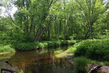
Photo by U.S. Forest Service
The primary feature of Silver Creek and Mondeaux River is the old-growth floodplain forest located at the junction of Mondeaux River and Silver Creek. The entire site represents a community and moisture gradient from river floodplain to upland dry-mesic pine and maple forest. Large-diameter trees provide a closed canopy over the slowly meandering rivers and associated backwaters and oxbow lakes. The bottoms of these two river systems flow through old-growth silver maple, red maple, and bur oak, with black ash, hemlock, and basswood. There are numerous large-diameter trees (18-26" diameter) in and across the rivers. The river basin is scoured by seasonal floodwaters maintaining an open understory rank with ferns, sedges, and forbs.
Clumps of shrubs are scattered and localized; mainly ironwood, speckled alder, hawthorn, and maple saplings. A rich herbaceous flora includes Dutchman's breeches, cut-leaved toothwort, wild leek, wild ginger, wood nettle, ostrich fern, trout lily, and marsh marigold. Nearby uplands contain a dry-mesic community dominated by white pine, red pine, red oak, red maple, and sugar maple. Some areas include large super-canopy trees over 26 inches in diameter. The shrub layer is heavy with hazelnut, and young maples. The ground flora consists of club mosses, bracken fern, maidenhair fern, hepaticas, early meadow-rue, blood-root, and rosy twisted stalk. Also included in this site are small areas of black ash swamp, hemlock forest (TMC), northern mesic forest (ATM), open sedge meadow, and shrub carr.
Also notable is a block of mature, second-growth white pine (16-26") isolated on the forest boundary by a curve of Silver Creek. Here large woody debris from a windstorm, while of recent origin, provides that character common in old-growth and unmanaged forests. Birds include pileated woodpecker, wood thrush, hermit thrush, blue-headed vireo, eastern wood-pewee, scarlet tanager, chestnut-sided warbler, Nashville warbler, ovenbird, and Baltimore oriole. Silver Creek and Mondeaux River is owned by the US Forest Service and was designated a State Natural Area in 2007.
Very few State Natural Areas have public facilities, but nearly all are open for a variety of recreational activities as indicated below. Generally, there are no picnic areas, restrooms, or other developments. Parking lots or designated parking areas are noted on individual SNA pages and maps. If a developed trail is present, it will normally be noted on the SNA map and/or under the Maps tab. A compass and topographic map or a GPS unit are useful tools for exploring larger, isolated SNAs.
The good majority of SNAs are isolated and have few or no facilities. Some SNAs have vehicle access lanes or parking lots, but their accessibility may vary depending on weather conditions. Parking lots and lanes are not plowed during winter. Hiking trails may be nonexistent or consist of undeveloped footpaths. A GPS unit or compass and a detailed topographic map are useful tools for exploring larger SNAs.
Non-DNR lands
Entrance fees: For non-DNR-owned SNAs, we are unaware of any vehicle or admission fees. However, please contact the landowner for more information.
Hunting and trapping
Other activities
Other allowable activities such as - but not limited to camping, geocaching and bicycling are determined by the landowner. Please contact them directly or visit their websites for details.
Location
Within the Chequamegon-Nicolet National Forest. Taylor County. T33N-1W, Sections 1-4. 541 acres.
Driving directions
The RNA can be accessed from the County Highway D dam over the Mondeaux River 8.5 miles west of Westboro. Canoe downstream 2 miles to the site.
The DNR's state natural areas program is comprised of lands owned by the state, private conservation organizations, municipalities, other governmental agencies, educational institutions and private individuals. While the majority of SNAs are open to the public, access may vary according to individual ownership policies. Public use restrictions may apply due to public safety, or to protect endangered or threatened species or unique natural features. Lands may be temporarily closed due to specific management activities.
Users are encouraged to contact the landowner for more specific details. The data shown on these maps have been obtained from various sources, and are of varying age, reliability, and resolution. The data may contain errors or omissions and should not be interpreted as a legal representation of legal ownership boundaries. To create your custom map where you can zoom to a specific location, please use the DNR's Mapping Application.
Silver Creek and Mondeaux River are owned by: U.S. Forest Service