Scott Lake and Shelp Lake
No. 117
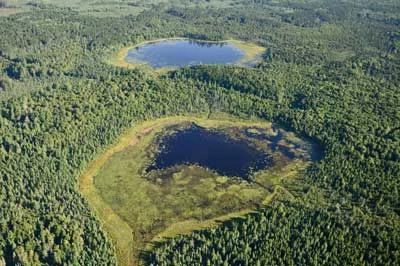
Photo by U.S. Forest Service
Scott and Shelp Lake features two scenic spring-fed wilderness lakes with remnant stands of pine and hemlock. The northern mesic forest is dominated by hemlock with a few super canopy white and red pines. Associated canopy species include sugar maple, yellow birch, basswood, and white spruce. The generally sparse shrub layer contains mountain maple, fly honeysuckle, beaked hazelnut, and red elder while the groundcover includes Canada mayflower, wood sorrel, bunchberry, and narrow beech fern.
The spring-fed Shelp Lake drains south to Scott Lake, which is itself drained by Scott Creek and flows to the Eagle River. Both are shallow soft water lakes and are completely undeveloped. Wetlands adjacent to the lakes include stands of swamp conifers dominated by black spruce and tamarack, an open bog of sphagnum moss, sedges and heaths, and a shrub swamp composed mainly of speckled alder. Characteristic nesting birds are blackburnian and black-throated green warblers, solitary vireo, gray jay, and olive-sided flycatchers. Osprey and bald eagles use the lakes for foraging. Scott Lake and Shelp Lake are owned by the U.S. Forest Service and were designated a State Natural Area in 1974.
Very few State Natural Areas have public facilities, but nearly all are open for a variety of recreational activities as indicated below. Generally, there are no picnic areas, restrooms, or other developments. Parking lots or designated parking areas are noted on individual SNA pages and maps. If a developed trail is present, it will normally be noted on the SNA map and/or under the Maps tab. A compass and topographic map or a GPS unit are useful tools for exploring larger, isolated SNAs.
The good majority of SNAs are isolated and have few or no facilities. Some SNAs have vehicle access lanes or parking lots, but their accessibility may vary depending on weather conditions. Parking lots and lanes are not plowed during winter. Hiking trails may be nonexistent or consist of undeveloped footpaths. A GPS unit or compass and a detailed topographic map are useful tools for exploring larger SNAs.
Non-DNR lands
Entrance fees: For non-DNR-owned SNAs, we are unaware of any vehicle or admission fees. However, please contact the landowner for more information.
Hunting and trapping
Other activities
Other allowable activities such as - but not limited to camping, geocaching and bicycling are determined by the landowner. Please contact them directly or visit their websites for details.
Location
Within the Chequamegon-Nicolet National Forest, Forest County. T38N-R12E, Sections 8, 9, 16-21, 29. 1,674 acres.
Driving directions
From the junction of Highways 45 and 32 in Three Lakes, go east on 32 for 4.7 miles, then east on Lake Julia Road for 0.6 miles, then south and east on Scott Lake Road (FR 2183) 2.6 miles to a parking area on the north side of the road. A trail and boardwalk lead north to Shelp Lake, and a trail south of the road leads through the forest.
The DNR's state natural areas program is comprised of lands owned by the state, private conservation organizations, municipalities, other governmental agencies, educational institutions and private individuals. While the majority of SNAs are open to the public, access may vary according to individual ownership policies. Public use restrictions may apply due to public safety, or to protect endangered or threatened species or unique natural features. Lands may be temporarily closed due to specific management activities.
Users are encouraged to contact the landowner for more specific details. The data shown on these maps have been obtained from various sources, and are of varying age, reliability, and resolution. The data may contain errors or omissions and should not be interpreted as a legal representation of legal ownership boundaries. To create your custom map where you can zoom to a specific location, please use the DNR's Mapping Application.
Scott Lake and Shelp Lake are owned by: U.S. Forest Service