Schmidt Maple Woods
No. 84
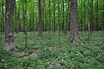
Photo by Aaron Carlson
Schmidt Maple Woods is situated on gently rolling Illinoisan glacial drift and features one of the best-known examples of southern mesic forest remaining in the west-central region of the state. A windstorm in 1980 toppled half the canopy in the northern portion of the site and created openings generating two strikingly different sapling releases with sugar maple dominating in the east and basswood, bitternut, hickory, and ash dominating the west. The southern half of the forest remains well structured with a tall closed canopy containing a large diversity of tree size classes and a multi-layered mid-canopy including species such as rock elm.
The herbaceous ground layer is diverse with numerous showy species such as squirrel corn, hepaticas, yellow trout lily, large-flowered trillium, Jacob's ladder, wild geranium, large-leaved aster, and violets. Great blue herons have nested on the site. The Woods is a memorial to the Franklin Schmidt family who lost their lives in a fire in 1935. A plaque marks the site of the tragedy. Schmidt Maple Woods is owned by the University of Wisconsin-Eau Claire and was designated a State Natural Area in 1970.
Very few State Natural Areas have public facilities, but nearly all are open for a variety of recreational activities as indicated below. Generally, there are no picnic areas, restrooms, or other developments. Parking lots or designated parking areas are noted on individual SNA pages and maps. If a developed trail is present, it will normally be noted on the SNA map and/or under the Maps tab. A compass and topographic map or a GPS unit are useful tools for exploring larger, isolated SNAs.
The good majority of SNAs are isolated and have few or no facilities. Some SNAs have vehicle access lanes or parking lots, but their accessibility may vary depending on weather conditions. Parking lots and lanes are not plowed during winter. Hiking trails may be nonexistent or consist of undeveloped footpaths. A GPS unit or compass and a detailed topographic map are useful tools for exploring larger SNAs.
Non-DNR lands
Entrance fees: For non-DNR-owned SNAs, we are unaware of any vehicle or admission fees. However, please contact the landowner for more information.
Hunting and trapping
Other activities
Other allowable activities such as - but not limited to camping, geocaching and bicycling are determined by the landowner. Please contact them directly or visit their websites for details.
Location
Clark County. T28N-R4W, Section 18. 86 acres.
Driving directions
From the intersection of State Highway 29 and County Highway NN in Stanley, go south on NN for about 1.5 miles, then east on County Highway N for 1 mile, then south on Copenhaver Road 1.25 miles to the northeast corner of the site. Park along the road and walk west into the woods.
The DNR's state natural areas program is comprised of lands owned by the state, private conservation organizations, municipalities, other governmental agencies, educational institutions and private individuals. While the majority of SNAs are open to the public, access may vary according to individual ownership policies. Public use restrictions may apply due to public safety, or to protect endangered or threatened species or unique natural features. Lands may be temporarily closed due to specific management activities.
Users are encouraged to contact the landowner for more specific details. The data shown on these maps have been obtained from various sources, and are of varying age, reliability, and resolution. The data may contain errors or omissions and should not be interpreted as a legal representation of legal ownership boundaries. To create your custom map where you can zoom to a specific location, please use the DNR's Mapping Application.
Schmidt Maple Woods is owned by: The UW Board of Regents