Schluckebier Prairie
No. 541
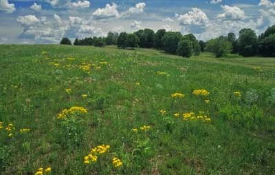
Photo by Thomas A. Meyer/DNR
Schluckebier Sand Prairie is one of the last surviving remnants of the 14,000-acre Sauk Prairie, a vast grassland that covered the area before settlement. The small dry to dry-mesic prairie lies in the Otter Creek watershed and is situated on part of an old Wisconsin River terrace. The site is just southwest of the moraines that mark the southern extent of the Pleistocene glaciation, placing it within Wisconsin's Driftless Area. The prairie supports a good diversity of native plants and insects including two rare species. Other plants include little bluestem, June grass, Virginia dwarf dandelion, short green milkweed, bird's-foot violet, pasqueflower, prairie smoke, flowering spurge, spiderwort, and rough blazing star.
Except for a few small patches on slopes and along the edges, it is believed that the entire site had been plowed as early as the 1850s. An area to the south was also grazed until 1969. Because of its sandy soil and rapid depletion of nutrients, the site was abandoned for cultivation purposes and native species that had disappeared were able to recolonize the prairie. Also present, perhaps due in part to human disturbance, are sand blows that provide microhabitats for specialists like false heather, a pioneer plant that helps stabilize the sand blows. Today, with a management regime of prescribed fire, brushing, and invasives control the condition of the prairie is improving. Schluckebier (SCHLUCK-e-beer) is a German name meaning "drink a beer". The site is owned by The Prairie Enthusiasts and was designated a State Natural Area in 2006.
Very few State Natural Areas have public facilities, but nearly all are open for a variety of recreational activities as indicated below. Generally, there are no picnic areas, restrooms, or other developments. Parking lots or designated parking areas are noted on individual SNA pages and maps. If a developed trail is present, it will normally be noted on the SNA map and/or under the Maps tab. A compass and topographic map or a GPS unit are useful tools for exploring larger, isolated SNAs.
The good majority of SNAs are isolated and have few or no facilities. Some SNAs have vehicle access lanes or parking lots, but their accessibility may vary depending on weather conditions. Parking lots and lanes are not plowed during winter. Hiking trails may be nonexistent or consist of undeveloped footpaths. A GPS unit or compass and a detailed topographic map are useful tools for exploring larger SNAs.
Non-DNR lands
Entrance fees: For non-DNR-owned SNAs, we are unaware of any vehicle or admission fees. However, please contact the landowner for more information.
Hunting and trapping
Other activities
Other allowable activities such as - but not limited to camping, geocaching and bicycling are determined by the landowner. Please contact them directly or visit their websites for details.
Location
Sauk County. T9N-R6E, Section 4; T10N-R6E, Section 33. 23 acres.
Driving directions
From the intersection of Highway 12 and County PF west of Sauk City, go west on PF 1.5 miles to a small dirt lane and parking area south of the road.
The DNR's state natural areas program is comprised of lands owned by the state, private conservation organizations, municipalities, other governmental agencies, educational institutions and private individuals. While the majority of SNAs are open to the public, access may vary according to individual ownership policies. Public use restrictions may apply due to public safety, or to protect endangered or threatened species or unique natural features. Lands may be temporarily closed due to specific management activities.
Users are encouraged to contact the landowner for more specific details. The data shown on these maps have been obtained from various sources, and are of varying age, reliability, and resolution. The data may contain errors or omissions and should not be interpreted as a legal representation of legal ownership boundaries. To create your custom map where you can zoom to a specific location, please use the DNR's Mapping Application.
Schluckebier Prairie is owned by: The Prairie Enthusiasts