Savage Lake
No. 693
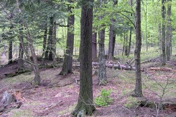
Photo by Wisconsin DNR
Savage Lake features high-quality upland and lowland natural communities, including northern mesic forest, northern wet-mesic forest as well as the undeveloped Savage Lake, two small spring ponds and forested bedrock outcrops. The northern mesic forest is dominated by sugar maple with hemlock, yellow birch, basswood and white cedar. The shrub layer is sparse with red elderberry, red raspberry, American fly honeysuckle and mountain maple. The herbaceous layer ranges from relatively depauperate with Pennsylvania sedge, wild sarsaparilla and large-leaved aster dominating, to more diverse with numerous spring ephemerals such as spring beauty, Dutchman’s breeches, squirrel-corn, yellow trout lily, broad-leaved toothwort, cut-leaved toothwort, wild leek, bloodroot and large-flowered trillium.
Also present are bishop’s-cap, tall white violet, downy yellow violet, blue cohosh, lady fern, hairy sweet cicely, maidenhair fern, numerous sedges, northern beech fern, rough-leaved rice grass, horse-gentian, mountain wood sorrel, blue-bead lily, shining club-moss and large-flowered bellwort. A significant proportion of the SNA is composed of forested wetlands of tamarack, white cedar, black ash and balsam fir. Shrubs include Labrador tea, velvet-leaf blueberry, speckled alder, and mountain maple. Herbs include three-seeded sedge, three-leaved goldthread, swamp false Solomon’s seal, bunchberry, fowl manna grass, slender sedge, small enchanter’s nightshade, crested wood fern, spinulose wood fern and nodding trillium.
Savage Lake represents a landscape-scale old-growth forest management opportunity and was cited in DNR’s Old-growth and Old Forests Handbook as a representative site for Old Forest in the reserved management class. Adjacent SNAs on the Chequamegon-Nicolet National Forest also contain old forest, and the entire site is embedded in a large tract of private forest legacy land that has been selectively managed for large saw logs. The combination of state, federal and easement lands makes this site one of the most significant areas to manage for old and old-growth forests within a contiguous forested landscape. While many upland stands have been actively managed for over a century, the integrity of the ground layer, including rare plants, remains. The site hosts an exceptional diversity of breeding birds, including forest interior species, conifer-dependent species and forest raptors. Savage Lake is owned by the DNR and was designated a State Natural Area in 2020.
Very few State Natural Areas have public facilities, but nearly all are open for a variety of recreational activities as indicated below. Generally, there are no picnic areas, restrooms, or other developments. Parking lots or designated parking areas are noted on individual SNA pages and maps. If a developed trail is present, it will normally be noted on the SNA map and/or under the Maps tab. A compass and topographic map or a GPS unit are useful tools for exploring larger, isolated SNAs.
The good majority of SNAs are isolated and have few or no facilities. Some SNAs have vehicle access lanes or parking lots, but their accessibility may vary depending on weather conditions. Parking lots and lanes are not plowed during winter. Hiking trails may be nonexistent or consist of undeveloped footpaths. A GPS unit or compass and a detailed topographic map are useful tools for exploring larger SNAs.
Entrance fees: Except for Parfrey's Glen, the Cambrian Outlook in the Dells of the Wisconsin River, SNAs within State Parks and some within State Forests, all other DNR-owned SNAs do not have any admission fees. For more information, see Wis. Admin. Code NR 45 [exit DNR]. For non-DNR-owned SNAs, we are unaware of any vehicle or admission fees. However, please contact the landowner for more information.
Allowable activities: DNR-owned land
The activities listed below are generally allowed on all DNR-owned SNA lands. Exceptions to this list of public uses, such as SNAs closed to hunting, are noted above and posted with signs on the property site.
- Hiking
- Fishing
- Cross country skiing
- Hunting
- Trapping
- Scientific research (permit required [PDF])
- Outdoor education
- Wild edibles (What is this?)
- Pets (Rules)
- Wildlife viewing
Prohibited activities: all SNAs
Although a handful of sites allow activities like primitive camping (e.g. Lower Chippewa River on sand bars) or horseback riding (e.g. S. Kettle Moraine), the activities listed below are generally prohibited on DNR-owned SNAs.
- Camping and campfires
- Collecting of animals (other than legally harvested species), non-edible fungi, rocks, minerals, fossils, archaeological artifacts, soil, downed wood, or any other natural material, alive or dead.
- Collecting for scientific research requires a permit issued by the DNR
- Collecting of plants including seeds, roots or other non-edible parts of herbaceous plants such as wildflowers or grasses
- Drones: Flying-related activities, including the use of drones, hang-gliders and model airplanes, are prohibited. Permission may be issued by the SNA Program for the use of drones for educational or research purposes
- Geocaching
- Horseback riding
- Rock climbing
- Vehicles, including bicycles, ATVs, aircraft, and snowmobiles except on trails and roadways designated for their use.
For rules governing state-owned SNAs and other state lands, please consult Chapter NR 45 Wis. Admin. Code [exit DNR].
Location
Within the Pine Popple Wild Rivers, Florence County. T39N-R16E, Sections 2, 3, 4, 10, 11. 1,882 acres.
Driving directions
Two DNR roads cross the SNA and connect from Savage Lake Road and the Goodman Grade. One road borders the eastern boundary and then enters north of Savage Lake and continues westward to the state ownership boundary. The second road traverses south of Savage, Dorothy, and Mud Lakes. It continues west onto industrial forest land. There is also a small parking area east of Savage Lake with a short road leading from the parking area to the lake. This road is in poor condition with soft soils prone to rutting.
The DNR's state natural areas program is comprised of lands owned by the state, private conservation organizations, municipalities, other governmental agencies, educational institutions and private individuals. While the majority of SNAs are open to the public, access may vary according to individual ownership policies. Public use restrictions may apply due to public safety, or to protect endangered or threatened species or unique natural features. Lands may be temporarily closed due to specific management activities.
Users are encouraged to contact the landowner for more specific details. The data shown on these maps have been obtained from various sources, and are of varying age, reliability, and resolution. The data may contain errors or omissions and should not be interpreted as a legal representation of legal ownership boundaries. To create your custom map where you can zoom to a specific location, please use the DNR's Mapping Application.
Savage Lake is owned by: Wisconsin DNR