Rush Creek
No. 170
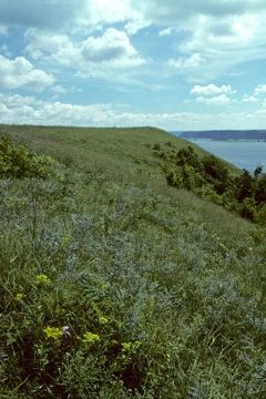
Photo by Thomas A. Meyer/DNR
The outstanding feature of Rush Creek is a two-mile-long series of dry, alkaline prairies situated on the steep southwest-facing limestone-capped bluffs of the Mississippi River. These “goat prairies”, named for their steep, rocky terrain, are part of the most extensive dry prairie remnants left in the state. While most Wisconsin prairies were lost to the plow or development, Rush Creek’s steepness and dry southwestern exposure are largely responsible for its preservation. Characteristic plants include lead plant, little blue-stem, side-oats grama, silky aster, blazing star, wood betony, compass plant, and bird’s-foot violet.
The narrow north and east-facing slopes bluff tops are forested with red and white oak and a significant amount of black walnut, hickory, basswood, sugar maple, and aspen. Common shrubs and mid-canopy species include gray and round-leaved dogwood, American hazelnut, sumac, and ironwood with a good diversity of woodland herbs and forbs. The spring-fed Rush Creek is cool and clear and supports a floodplain forest of silver and red maples, elm, cottonwood, river birch, and willow. The extensive nature and diversity of vegetation make Rush Creek important habitat for numerous rare plants and animals. Rush Creek is owned by the DNR and was designated a State Natural Area in 1981.
Very few State Natural Areas have public facilities, but nearly all are open for various recreational activities as indicated below. Generally, there are no picnic areas, restrooms, or other developments. Parking lots or designated parking areas are noted on individual SNA pages and maps. If a developed trail is present, it will normally be noted on the SNA map and/or under the Maps tab. A compass and topographic map or a GPS unit are useful tools for exploring larger, isolated SNAs.
The good majority of SNAs are isolated and have few or no facilities. Some SNAs have vehicle access lanes or parking lots, but their accessibility may vary depending on weather conditions. Parking lots and lanes are not plowed during winter. Hiking trails may be nonexistent or consist of undeveloped footpaths. A GPS unit or compass and a detailed topographic map are useful tools for exploring larger SNAs.
Entrance fees: Except for Parfrey's Glen, the Cambrian Outlook in the Dells of the Wisconsin River, SNAs within State Parks and some within State Forests, all other DNR-owned SNAs do not have any admission fees. For more information, see Wis. Admin. Code NR 45 [exit DNR]. For non-DNR-owned SNAs, we are unaware of any vehicle or admission fees. However, please contact the landowner for more information.
Allowable activities: DNR-owned land
The activities listed below are generally allowed on all DNR-owned SNA lands. Exceptions to this list of public uses, such as SNAs closed to hunting, are noted above and posted with signs on the property site.
- Hiking
- Fishing
- Cross country skiing
- Hunting
- Trapping
- Scientific research (permit required [PDF])
- Outdoor education
- Wild edibles (What is this?)
- Pets (Rules)
- Wildlife viewing
Prohibited activities: all SNAs
Although a handful of sites allow activities like primitive camping (e.g. Lower Chippewa River on sand bars) or horseback riding (e.g. S. Kettle Moraine), the activities listed below are generally prohibited on DNR-owned SNAs.
- Camping and campfires
- Collecting of animals (other than legally harvested species), non-edible fungi, rocks, minerals, fossils, archaeological artifacts, soil, downed wood, or any other natural material, alive or dead.
- Collecting for scientific research requires a permit issued by the DNR
- Collecting of plants including seeds, roots or other non-edible parts of herbaceous plants such as wildflowers or grasses
- Drones: Flying-related activities, including the use of drones, hang-gliders and model airplanes, are prohibited. Permission may be issued by the SNA Program for the use of drones for educational or research purposes
- Geocaching
- Horseback riding
- Rock climbing
- Vehicles, including bicycles, ATVs, aircraft, and snowmobiles except on trails and roadways designated for their use.
For rules governing state-owned SNAs and other state lands, please consult Chapter NR 45 Wis. Admin. Code [exit DNR].
Location
Crawford County. T10N-R6W, Sections 5, 6, 7. T10N-R7W, Section 1. T11N-R6W, Sections 19, 21, 28-33. T11N-R7W, Sections 11, 25, 36. 3,187 acres.
Driving directions
From the intersection of State Highway 35 and County Highway C in Ferryville, go north on Highway 35 for 3.1 miles, then northeast on Rush Creek Road for 0.5 miles to a parking area west of the road. Cross the road and walk east on an access lane to the blufftop. Or, continue north on 35 from its junction with Rush Creek Road 0.8 miles to a parking area. Walk up the slope.
The DNR's state natural areas program is comprised of lands owned by the state, private conservation organizations, municipalities, other governmental agencies, educational institutions and private individuals. While the majority of SNAs are open to the public, access may vary according to individual ownership policies. Public use restrictions may apply due to public safety, or to protect endangered or threatened species or unique natural features. Lands may be temporarily closed due to specific management activities.
Users are encouraged to contact the landowner for more specific details. The data shown on these maps have been obtained from various sources, and are of varying age, reliability, and resolution. The data may contain errors or omissions and should not be interpreted as a legal representation of legal ownership boundaries. To create your custom map where you can zoom to a specific location, please use the DNR's Mapping Application.
Rush Creek is owned by: Wisconsin DNR
Management objectives and prescriptions
- Conduct prescribed burns to enhance the prairie and savanna.
- Remove brush from the prairie, savanna and especially the edge.
- Remove invasive species, especially garlic mustard and teasel.
- Convert the sharecrop fields to prairie, savanna, and forest land.
- Provide and maintain access points, informational and boundary signs.
- Continue to acquire land within the project boundary.