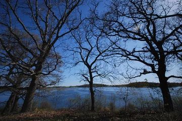
Rose Lake
No. 538

Photo by Josh Mayer
Rose Lake is a shallow, hard water seepage lake surrounded by wetlands, oak openings, and steep hills that provide fantastic views of the lake. With a maximum depth of 5 feet, Rose Lake contains a submerged aquatic plant community dominated by Illinois pondweed, grass-leaved pondweed, and coon's-tail. Other aquatics include common water milfoil, common pondweed, comb pondweed, and common bladderwort. Common and star duckweed with a common water-meal float on the surface.
The west side of the lake is dominated by a large floating mat of American woolly-fruit sedge, blue-joint grass, and spike rush. The exposed mud flats attract numerous shorebirds such as pectoral sandpiper, least sandpiper, solitary sandpiper, and lesser yellowlegs. The lake and surrounding wetlands are also important breeding habitat for many rare birds. Other breeding birds are the Sandhill Crane, great blue heron, pied-billed grebe, American coot, common moorhen, blue-winged teal, ruddy duck, tree swallow, bank swallow, and marsh wren.
Large numbers of yellow-headed blackbirds also nest here. American white pelicans began using the wetland in 2003 when over 800 were recorded. Soft-stem bulrush and cat-tails ring the north, south, and east shores. Numerous freshwater sponges and a diverse dragonfly/damselfly population indicate a lack of serious water quality problems. Prairie, savanna, and wetland habitats are being restored around the lake. Rose Lake is owned by Jefferson County and was designated a State Natural Area in 2006.
Very few State Natural Areas have public facilities, but nearly all are open for various recreational activities as indicated below. Generally, there are no picnic areas, restrooms, or other developments. Parking lots or designated parking areas are noted on individual SNA pages and maps. If a developed trail is present, it will normally be noted on the SNA map and/or under the Maps tab. A compass and topographic map or a GPS unit are useful tools for exploring larger, isolated SNAs.
The good majority of SNAs are isolated and have few or no facilities. Some SNAs have vehicle access lanes or parking lots, but their accessibility may vary depending on weather conditions. Parking lots and lanes are not plowed during winter. Hiking trails may be nonexistent or consist of undeveloped footpaths. A GPS unit or compass and a detailed topographic map are useful tools for exploring larger SNAs.
Non-DNR lands
Entrance fees: For non-DNR-owned SNAs, we are unaware of any vehicle or admission fees. However, please contact the landowner for more information.
Hunting and trapping
Other activities
Other allowable activities such as - but not limited to camping, geocaching and bicycling are determined by the landowner. Please contact them directly or visit their websites for details.
Location
Jefferson County. T6N-R14E, Sections 19, 20, 29 and 30. 480 acres.
Driving directions
From the intersection of Highways 26 and 12 in Fort Atkinson, go west on 12 for 1.2 miles, then north on Radloff Lane for about 0.6 miles, then east to a parking area. A trail provides access to the lake.
The DNR's state natural areas program is comprised of lands owned by the state, private conservation organizations, municipalities, other governmental agencies, educational institutions and private individuals. While the majority of SNAs are open to the public, access may vary according to individual ownership policies. Public use restrictions may apply due to public safety, or to protect endangered or threatened species or unique natural features. Lands may be temporarily closed due to specific management activities.
Users are encouraged to contact the landowner for more specific details. The data shown on these maps have been obtained from various sources, and are of varying age, reliability, and resolution. The data may contain errors or omissions and should not be interpreted as a legal representation of legal ownership boundaries. To create your custom map where you can zoom to a specific location, please use the DNR's Mapping Application.
Rose Lake is owned by: Jefferson County
