Riley Lake
No. 439
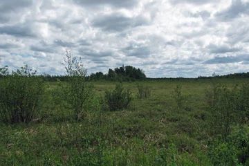
Photo by U.S. Forest Service
Riley Lake features a vast peatland complex on washed till-outwash in old glacial drainages. The primary characteristic is the large, continuous bog and spruce muskeg community covering many acres. Several eskers forested with red pine wind through the site in a north-south direction. The bog is extremely important in maintaining the water quality and quantity of the area. It retains a significant amount of water, which feeds numerous streams that eventually make their way to the Chippewa River. Cotton grass, leatherleaf, bog rosemary, and bog laurel dominate the bog, which grades into a black spruce and tamarack swamp and later to alder thicket at the edges of the uplands. Riley Lake is owned by the US Forest Service and was designated a State Natural Area in 2007.
Very few State Natural Areas have public facilities, but nearly all are open for a variety of recreational activities as indicated below. Generally, there are no picnic areas, restrooms, or other developments. Parking lots or designated parking areas are noted on individual SNA pages and maps. If a developed trail is present, it will normally be noted on the SNA map and/or under the Maps tab. A compass and topographic map or a GPS unit are useful tools for exploring larger, isolated SNAs.
The good majority of SNAs are isolated and have few or no facilities. Some SNAs have vehicle access lanes or parking lots, but their accessibility may vary depending on weather conditions. Parking lots and lanes are not plowed during winter. Hiking trails may be nonexistent or consist of undeveloped footpaths. A GPS unit or compass and a detailed topographic map are useful tools for exploring larger SNAs.
Non-DNR lands
Entrance fees: For non-DNR-owned SNAs, we are unaware of any vehicle or admission fees. However, please contact the landowner for more information.
Hunting and trapping
Other activities
Other allowable activities such as - but not limited to camping, geocaching and bicycling are determined by the landowner. Please contact them directly or visit their websites for details.
Location
Within the Chequamegon-Nicolet National Forest, Price County. T38N-R2E, Sections 1, 11, 12. T38N-R3E, Sections 6, 7. 1,252 acres.
Driving directions
From the intersection of State Highways 13 and 70 in Fifield, go east on 70 for 11.5 miles, then south on FR 505 (Hemlock Rd) for 6 miles, then west on FR 136 (Gates Lake Rd) for 0.5 miles. The site lies south of the road.
The DNR's state natural areas program is comprised of lands owned by the state, private conservation organizations, municipalities, other governmental agencies, educational institutions and private individuals. While the majority of SNAs are open to the public, access may vary according to individual ownership policies. Public use restrictions may apply due to public safety, or to protect endangered or threatened species or unique natural features. Lands may be temporarily closed due to specific management activities.
Users are encouraged to contact the landowner for more specific details. The data shown on these maps have been obtained from various sources, and are of varying age, reliability, and resolution. The data may contain errors or omissions and should not be interpreted as a legal representation of legal ownership boundaries. To create your custom map where you can zoom to a specific location, please use the DNR's Mapping Application.
Riley Lake is owned by: US Forest Service