Ridgeway Pine Relict
No. 326
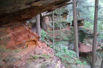
Photo by Thomas A. Meyer/DNR
Ridgeway Pine Relict features a spectacular site with eight separate pine relicts set among soaring sandstone cliffs, numerous rock outcrops, shallow caves and rock shelters. Pine relicts are southern Wisconsin pine forests that have persisted since the last glacier receded some 12,000 years ago when a cooler climate was favorable for the growth of pine forests. As the climate warmed prairie and oak woodlands replaced the pine and today, remnant pine forests remain only on steep slopes and rocky cliffs in the Driftless Area.
These rocky outcrops protected the pine remnants from fire and allowed the pines to reach old-growth status. The relict communities are unlike the northern pine forests because they contain both northern and southern plant species. Within the pine relict areas, white pine is generally more abundant than red pine, but there is a good reproduction of both species. Jack Pine is also present. Sugar maple, mountain maple, yellow birch and hemlock constitute a smaller component. The ground flora includes pipsissewa, shin-leaf, wintergreen, huckleberry and Canada mayflower.
There is also a high diversity of ferns present including bracken, bulblet bladder, marginal wood and interrupted fern. Between the relicts and surrounding them is forested land dominated by white oak with bur and red oak, black cherry, white birch, shagbark and bitternut hickory. Other significant features include sandstone cliffs with shaded and open plant communities, diverse spring runs, sedge meadows and dry-mesic prairie. Ridgeway Pine Relicts is owned by the DNR and was designated a State Natural Area in 1998.
Very few State Natural Areas have public facilities, but nearly all are open for a variety of recreational activities as indicated below. Generally, there are no picnic areas, restrooms, or other developments. Parking lots or designated parking areas are noted on individual SNA pages and maps. If a developed trail is present, it will normally be noted on the SNA map and/or under the Maps tab. A compass and topographic map or a GPS unit are useful tools for exploring larger, isolated SNAs.
The good majority of SNAs are isolated and have few or no facilities. Some SNAs have vehicle access lanes or parking lots, but their accessibility may vary depending on weather conditions. Parking lots and lanes are not plowed during winter. Hiking trails may be nonexistent or consist of undeveloped footpaths. A GPS unit or compass and a detailed topographic map are useful tools for exploring larger SNAs.
Entrance fees: Except for Parfrey's Glen, the Cambrian Outlook in the Dells of the Wisconsin River, SNAs within State Parks and some within State Forests, all other DNR-owned SNAs do not have any admission fees. For more information, see Wis. Admin. Code NR 45 [exit DNR]. For non-DNR-owned SNAs, we are unaware of any vehicle or admission fees. However, please contact the landowner for more information.
Allowable activities: DNR-owned land
The activities listed below are generally allowed on all DNR-owned SNA lands. Exceptions to this list of public uses, such as SNAs closed to hunting, are noted above and posted with signs on the property site.
- Hiking
- Fishing
- Cross country skiing
- Hunting
- Trapping
- Scientific research (permit required [PDF])
- Outdoor education
- Wild edibles (What is this?)
- Pets (Rules)
- Wildlife viewing
Prohibited activities: all SNAs
Although a handful of sites allow activities like primitive camping (e.g. Lower Chippewa River on sand bars) or horseback riding (e.g. S. Kettle Moraine), the activities listed below are generally prohibited on DNR-owned SNAs.
- Camping and campfires
- Collecting of animals (other than legally harvested species), non-edible fungi, rocks, minerals, fossils, archaeological artifacts, soil, downed wood, or any other natural material, alive or dead.
- Collecting for scientific research requires a permit issued by the DNR
- Collecting of plants including seeds, roots or other non-edible parts of herbaceous plants such as wildflowers or grasses
- Drones: Flying-related activities, including the use of drones, hang-gliders and model airplanes, are prohibited. Permission may be issued by the SNA Program for the use of drones for educational or research purposes
- Geocaching
- Horseback riding
- Rock climbing
- Vehicles, including bicycles, ATVs, aircraft, and snowmobiles except on trails and roadways designated for their use.
For rules governing state-owned SNAs and other state lands, please consult Chapter NR 45 Wis. Admin. Code [exit DNR].
Location
Iowa County. T6N-R4E, Sections 3, 9, 10, 11, 15, 16. 546 acres.
Driving directions
There are two units of the natural area, a large northern unit and a small southern unit.
For the northern unit, there are two primary points of access:
1) From the intersection of County HHH and H in Ridgeway, go north on H about 0.6 miles to an access lane on the west side of the highway marked with a large State Natural Area sign. A parking lot is available on the east side of the road, 100 yards north of the SNA access at Love Creek Fishery Area. Walk west along the access lane into the natural area. Although there are no formally maintained trails, the Friends of Ridgeway Pines has walking routes that take visitors to one of the pine relicts and other points of interest. Refer to the Friends brochure in the Resources tab, and map within the "Maps" tab for more details.
2) From the intersection of Ridgevue Road and Highway 18/151 just west of Ridgeway, go north on Ridgevue Road 1.4 miles to a parking lot west of the road. DNR ownership abuts the road here and at other points along Ridgevue Road. A network of old access trails traverses western portions of the natural area.
To access the southern unit: From the junction of Ridgevue Road and Highway 18/151 just west of Ridgeway, go north on Ridgevue Road one mile to a gravel walk-in public access lane on the west side of the road marked by fire number 3754. Vehicles are not allowed to drive on this lane. This access easement is on private land and the first portion serves as a private driveway to a residence. Park along the road, or a parking lot is also available 0.35 miles further north on Ridgevue Road.
To access the public property, walk due west along the lane approximately 1200' until the lane curves to the north. At this point, visitors must continue walking due west along the fence line a total of 0.5 miles to the SE corner of the public property. One or more electric fence lines may be encountered here as the easement crosses an active pasture. A wooden ladder structure provides access over the electric fences. Refer to the map for site boundaries and unit locations.
The DNR's state natural areas program is comprised of lands owned by the state, private conservation organizations, municipalities, other governmental agencies, educational institutions and private individuals. While the majority of SNAs are open to the public, access may vary according to individual ownership policies. Public use restrictions may apply due to public safety, or to protect endangered or threatened species or unique natural features. Lands may be temporarily closed due to specific management activities.
Users are encouraged to contact the landowner for more specific details. The data shown on these maps have been obtained from various sources, and are of varying age, reliability, and resolution. The data may contain errors or omissions and should not be interpreted as a legal representation of legal ownership boundaries. To create your custom map where you can zoom to a specific location, please use the DNR's Mapping Application.
Ridgeway Pine Relict is owned by: Wisconsin DNR