Rice Creek
No. 504
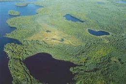
Photo by R. Eckstein
Rice Creek SNA features a two-mile stretch of creek surrounded by a large wetland complex of conifer swamp, boreal rich fen, sedge meadow, and northern wet-mesic forest. White cedar dominates the forest but the cover is variable with balsam fir, black spruce, tamarack, black ash, red maple, white spruce, yellow birch, paper birch, and hemlock all present in the canopy. Thickets of mountain maple and alder are found in some areas. The understory is diverse and includes heart-leaf twayblade, blunt-leaved orchid, naked miterwort, three-leaved goldthread, yellow blue-bead lily, early coralroot, and striped coralroot. The slow, warm, hard-water Rice Creek has extensive lush beds of aquatic macrophytes including dense stands of wild rice.
Just west of Keego Lake are two small, but high-quality stands of old-growth hemlock with super-canopy white and red pines. The undeveloped, 24-acre lake is a deep, soft-water seepage lake with a maximum depth of 18 feet. Situated between Rice Creek and the rich conifer swamp is an undisturbed, diverse boreal-rich fen, which is fed by a small seepage flowing through the westernmost portion. Characteristic species include American woolly-fruit sedge, bog birch, pitcher plant, bog buckbean, three-leaf Solomon's-seal, alpine cotton grass, and marsh cinquefoil. Orchids are well-represented with at least seven species present. Birds include barred owl, red-breasted nuthatch, pine siskin, and winter wren. Rice Creek is owned by the DNR and was designated a State Natural Area in 2007.
Very few State Natural Areas have public facilities, but nearly all are open for various recreational activities as indicated below. Generally, there are no picnic areas, restrooms, or other developments. Parking lots or designated parking areas are noted on individual SNA pages and maps. If a developed trail is present, it will normally be noted on the SNA map and/or under the Maps tab. A compass and topographic map or a GPS unit are useful tools for exploring larger, isolated SNAs.
The good majority of SNAs are isolated and have few or no facilities. Some SNAs have vehicle access lanes or parking lots, but their accessibility may vary depending on weather conditions. Parking lots and lanes are not plowed during winter. Hiking trails may be nonexistent or consist of undeveloped footpaths. A GPS unit or compass and a detailed topographic map are useful tools for exploring larger SNAs.
Entrance fees: Except for Parfrey's Glen, the Cambrian Outlook in the Dells of the Wisconsin River, SNAs within State Parks and some within State Forests, all other DNR-owned SNAs do not have any admission fees. For more information, see Wis. Admin. Code NR 45 [exit DNR]. For non-DNR-owned SNAs, we are unaware of any vehicle or admission fees. However, please contact the landowner for more information.
Allowable activities: DNR-owned land
The activities listed below are generally allowed on all DNR-owned SNA lands. Exceptions to this list of public uses, such as SNAs closed to hunting, are noted above and posted with signs on the property site.
- Hiking
- Fishing
- Cross country skiing
- Hunting
- Trapping
- Scientific research (permit required [PDF])
- Outdoor education
- Wild edibles (What is this?)
- Pets (Rules)
- Wildlife viewing
Prohibited activities: all SNAs
Although a handful of sites allow activities like primitive camping (e.g. Lower Chippewa River on sand bars) or horseback riding (e.g. S. Kettle Moraine), the activities listed below are generally prohibited on DNR-owned SNAs.
- Camping and campfires
- Collecting of animals (other than legally harvested species), non-edible fungi, rocks, minerals, fossils, archaeological artifacts, soil, downed wood, or any other natural material, alive or dead.
- Collecting for scientific research requires a permit issued by the DNR
- Collecting of plants including seeds, roots or other non-edible parts of herbaceous plants such as wildflowers or grasses
- Drones: Flying-related activities, including the use of drones, hang-gliders and model airplanes, are prohibited. Permission may be issued by the SNA Program for the use of drones for educational or research purposes
- Geocaching
- Horseback riding
- Rock climbing
- Vehicles, including bicycles, ATVs, aircraft, and snowmobiles except on trails and roadways designated for their use.
For rules governing state-owned SNAs and other state lands, please consult Chapter NR 45 Wis. Admin. Code [exit DNR].
Location
Within the Northern Highland-American Legion State Forest, Vilas County. T42N-R6E, Section 4. T43N-R6E, Sections 28, 33, 34, 35. 435 acres.
Driving directions
The area is best accessed by canoe. From the intersection of County M (Cut-off Road) and County K in Boulder Junction, go west on County K for 4.3 miles, then north on Bear Lake Road for 2.3 miles, then north on Round Lake Road for 1.2 miles to boat access. The site is located between Round Lake and Big Lake.
The DNR's state natural areas program is comprised of lands owned by the state, private conservation organizations, municipalities, other governmental agencies, educational institutions and private individuals. While the majority of SNAs are open to the public, access may vary according to individual ownership policies. Public use restrictions may apply due to public safety, or to protect endangered or threatened species or unique natural features. Lands may be temporarily closed due to specific management activities.
Users are encouraged to contact the landowner for more specific details. The data shown on these maps have been obtained from various sources, and are of varying age, reliability, and resolution. The data may contain errors or omissions and should not be interpreted as a legal representation of legal ownership boundaries. To create your custom map where you can zoom to a specific location, please use the DNR's Mapping Application.
Rice Creek is owned by: Wisconsin DNR