Red Oak Bottoms
No. 523
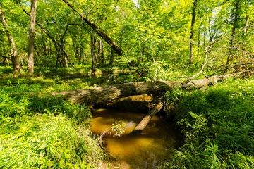
Photo by Josh Mayer
Situated along Hemlock Creek, Red Oak Bottoms supports an old-growth floodplain forest, which contains an unusual abundance of red oak in the canopy. While large floodplain forests occasionally have a red oak component, it is unique to have red oak co-dominant in these situations. Along with silver maple, this one and three-quarter mile reach of the creek supports basswood and some swamp white oak. The 35-mile Hemlock Creek is a soft-water stream that flows in a southerly direction and joins the Yellow River south of Babcock. Sand, gravel, and rubble are the dominant bottom types, but boulders, bedrock, and silt are also present.
Fish include walleye, northern pike, bluegill, rock bass, bullheads, perch, and pumpkinseed. Migrating ducks use the creek and mallard, teal, and wood ducks nest along the stream. The large maple and red oaks provide important habitat for a state-threatened bird while numerous cavities offer nesting sites for prothonotary warblers and brown creepers. Red Oak Bottoms is owned by Wood County and was designated a State Natural Area in 2007.
Very few State Natural Areas have public facilities, but nearly all are open for a variety of recreational activities as indicated below. Generally, there are no picnic areas, restrooms, or other developments. Parking lots or designated parking areas are noted on individual SNA pages and maps. If a developed trail is present, it will normally be noted on the SNA map and/or under the Maps tab. A compass and topographic map or a GPS unit are useful tools for exploring larger, isolated SNAs.
The good majority of SNAs are isolated and have few or no facilities. Some SNAs have vehicle access lanes or parking lots, but their accessibility may vary depending on weather conditions. Parking lots and lanes are not plowed during winter. Hiking trails may be nonexistent or consist of undeveloped footpaths. A GPS unit or compass and a detailed topographic map are useful tools for exploring larger SNAs.
Non-DNR lands
Entrance fees: For non-DNR-owned SNAs, we are unaware of any vehicle or admission fees. However, please contact the landowner for more information.
Hunting and trapping
Other activities
Other allowable activities such as - but not limited to camping, geocaching and bicycling are determined by the landowner. Please contact them directly or visit their websites for details.
Location
Within the Wood County Forest. T22N-R4E, Section 17. 25 acres.
Driving directions
From the intersection of Highway 80 and 54 nearly one mile south of Dexterville, go east on 54 4.4 miles, then north on Hemlock Trail 1.6 miles to the railroad tracks. Walk west 1.2 miles to Hemlock Creek. Walk north into the site.
The DNR's state natural areas program is comprised of lands owned by the state, private conservation organizations, municipalities, other governmental agencies, educational institutions and private individuals. While the majority of SNAs are open to the public, access may vary according to individual ownership policies. Public use restrictions may apply due to public safety, or to protect endangered or threatened species or unique natural features. Lands may be temporarily closed due to specific management activities.
Users are encouraged to contact the landowner for more specific details. The data shown on these maps have been obtained from various sources, and are of varying age, reliability, and resolution. The data may contain errors or omissions and should not be interpreted as a legal representation of legal ownership boundaries. To create your custom map where you can zoom to a specific location, please use the DNR's Mapping Application.
Red Oak Bottoms is owned by: Wood County