Red Cedar River Savanna
No. 412
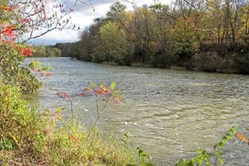
Photo by Tim Kiser
Located on sand islands and terraces within the Red Cedar River floodplain, the Red Cedar River Savanna features a unique dry savanna on riverine sand and gravel deposits. A mosaic of natural features is present on this river island including pine-oak savanna, patches of barrens, backwater sloughs, open sand and gravel bars, and floodplain forest. Jack pine and bur oak are scattered throughout the openings and dominate the eastern portion of the island while a canopy of white pine, swamp white oak, and green ash dominate the island's western side.
The ground layer is diverse and contains at least 27 savanna indicator plant species including prairie brome, silky wild rye, New Jersey tea, woodland thistle, goat's rue, Canada hawkweed, and fringed puccoon. An abundance of prairie dropseed is also present indicating a lack of intensive past grazing. Numerous prairie species are also present and include big bluestem, little bluestem, June grass, side-oats grama, sky-blue aster, wild bergamot, white prairie clover, and leadplant. Near the center of the island is an area of old oxbow lakes surrounded by a narrow fringe of silver maple. Around the periphery are gravel deposits with early successional vegetation including wild rye, switchgrass, and numerous sedges. Red Cedar River is owned by the DNR and was designated a State Natural Area in 2005.
Very few State Natural Areas have public facilities, but nearly all are open for a variety of recreational activities as indicated below. Generally, there are no picnic areas, restrooms, or other developments. Parking lots or designated parking areas are noted on individual SNA pages and maps. If a developed trail is present, it will normally be noted on the SNA map and/or under the Maps tab. A compass and topographic map or a GPS unit are useful tools for exploring larger, isolated SNAs.
The good majority of SNAs are isolated and have few or no facilities. Some SNAs have vehicle access lanes or parking lots, but their accessibility may vary depending on weather conditions. Parking lots and lanes are not plowed during winter. Hiking trails may be nonexistent or consist of undeveloped footpaths. A GPS unit or compass and a detailed topographic map are useful tools for exploring larger SNAs.
Entrance fees: Except for Parfrey's Glen, the Cambrian Outlook in the Dells of the Wisconsin River, SNAs within State Parks and some within State Forests, all other DNR-owned SNAs do not have any admission fees. For more information, see Wis. Admin. Code NR 45 [exit DNR]. For non-DNR-owned SNAs, we are unaware of any vehicle or admission fees. However, please contact the landowner for more information.
Allowable activities: DNR-owned land
The activities listed below are generally allowed on all DNR-owned SNA lands. Exceptions to this list of public uses, such as SNAs closed to hunting, are noted above and posted with signs on the property site.
- Hiking
- Fishing
- Cross country skiing
- Hunting
- Trapping
- Scientific research (permit required [PDF])
- Outdoor education
- Wild edibles (What is this?)
- Pets (Rules)
- Wildlife viewing
Prohibited activities: all SNAs
Although a handful of sites allow activities like primitive camping (e.g. Lower Chippewa River on sand bars) or horseback riding (e.g. S. Kettle Moraine), the activities listed below are generally prohibited on DNR-owned SNAs.
- Camping and campfires
- Collecting of animals (other than legally harvested species), non-edible fungi, rocks, minerals, fossils, archaeological artifacts, soil, downed wood, or any other natural material, alive or dead.
- Collecting for scientific research requires a permit issued by the DNR
- Collecting of plants including seeds, roots or other non-edible parts of herbaceous plants such as wildflowers or grasses
- Drones: Flying-related activities, including the use of drones, hang-gliders and model airplanes, are prohibited. Permission may be issued by the SNA Program for the use of drones for educational or research purposes
- Geocaching
- Horseback riding
- Rock climbing
- Vehicles, including bicycles, ATVs, aircraft, and snowmobiles except on trails and roadways designated for their use.
For rules governing state-owned SNAs and other state lands, please consult Chapter NR 45 Wis. Admin. Code [exit DNR].
Location
Dunn County. T29N-R12W, Sections 11, 12, 13, 14. 190 acres.
Driving directions
From the intersection of County BB (Railroad Ave) and Highway 40 in Colfax, go west on County BB for 3 miles, then west for 1 mile on 850th Avenue, then north on 730th Street for 0.5 miles. This will take you onto Dunn County land. Do not take the left fork in the road as this leads to private land. Park and walk west into the SNA. Signs mark the SNA boundary. To access the SNA portion across the river, from Colfax, go west on County BB for 3 miles, then west on 850th Avenue for 0.25 miles to a sand/gravel road to the right with a Dobbs Landing sign. Continue north 0.5 miles, then go left at the fork and continue about 0.35 miles to a canoe landing.
The DNR's state natural areas program is comprised of lands owned by the state, private conservation organizations, municipalities, other governmental agencies, educational institutions and private individuals. While the majority of SNAs are open to the public, access may vary according to individual ownership policies. Public use restrictions may apply due to public safety, or to protect endangered or threatened species or unique natural features. Lands may be temporarily closed due to specific management activities.
Users are encouraged to contact the landowner for more specific details. The data shown on these maps have been obtained from various sources, and are of varying age, reliability, and resolution. The data may contain errors or omissions and should not be interpreted as a legal representation of legal ownership boundaries. To create your custom map where you can zoom to a specific location, please use the DNR's Mapping Application.
Red Cedar River Savanna is owned by: Wisconsin DNR