Red Banks Alvar
No. 332
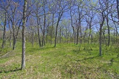
Photo by Thomas A. Meyer/DNR
Red Banks Alvar supports Wisconsin's best example of an Alvar community - a rare community type that occurs on flat limestone or dolomitic bedrock with very shallow soils. An unusual blend of boreal, southern and prairie species, relicts of the post-glacial environment and the warmer, dryer period that followed, characterize Alvar ecosystems. Red Banks Alvar contains one of the most diverse land snail communities known in the Midwest and is one of the most important areas in Wisconsin for snails.
Colonies of 25 different groups of these glacial relicts can be found from the base to the top of the escarpment. Of interest is the number of rare and glacial relict snail taxa that are present. In many aspects, the thin-soiled, sparsely vegetated landscape resembles a dry oak savanna dominated by open-grown bur oak and white oak. However, the trees are not especially large owing to the harsh growing conditions. But looks can be deceiving, as some of the oaks are very old. In many areas, the shrub and sapling layer is dense with red cedar, common juniper, and snowberry.
Butterfly collections in the early 1980s documented at least 20 species within the oak savanna community. On the talus slope below the dolomite escarpment is an old-growth mesic forest dominated by sugar maple, slippery elm and basswood, with an understory characterized by a rich flora of spring ephemerals. Several plant species are at their northeastern range limit in Wisconsin at this site including American bladdernut, glade fern, and eastern wahoo. Red Banks Alvar is owned by the DNR and the Northeast Wisconsin Land Trust. It was designated a State Natural Area in 2001.
Very few State Natural Areas have public facilities, but nearly all are open for a variety of recreational activities as indicated below. Generally, there are no picnic areas, restrooms, or other developments. Parking lots or designated parking areas are noted on individual SNA pages and maps. If a developed trail is present, it will normally be noted on the SNA map and/or under the Maps tab. A compass and topographic map or a GPS unit are useful tools for exploring larger, isolated SNAs.
The good majority of SNAs are isolated and have few or no facilities. Some SNAs have vehicle access lanes or parking lots, but their accessibility may vary depending on weather conditions. Parking lots and lanes are not plowed during winter. Hiking trails may be nonexistent or consist of undeveloped footpaths. A GPS unit or compass and a detailed topographic map are useful tools for exploring larger SNAs.
Hunting and trapping
Allowable activities: DNR-owned land
The activities listed below are generally allowed on all DNR-owned SNA lands. Exceptions to this list of public uses, such as SNAs closed to hunting, are noted above and posted with signs on the property site.
- Hiking
- Fishing
- Cross country skiing
- Hunting
- Trapping
- Scientific research (permit required [PDF])
- Outdoor education
- Wild edibles (What is this?)
- Pets (Rules)
- Wildlife viewing
Prohibited activities: all SNAs
- Camping and campfires
- Collecting of animals (other than legally harvested species), non-edible fungi, rocks, minerals, fossils, archaeological artifacts, soil, downed wood, or any other natural material, alive or dead.
- Collecting for scientific research requires a permit issued by the DNR
- Collecting of plants including seeds, roots or other non-edible parts of herbaceous plants such as wildflowers or grasses
- Geocaching
- Horseback riding
- Rock climbing
- Vehicles, including bicycles, ATVs, aircraft, and snowmobiles except on trails and roadways designated for their use.
For rules governing state-owned SNAs and other state lands, please consult Chapter NR 45 Wis. Admin. Code [exit DNR].
Location
Brown County. T25N-R22E, Sections 26, 29, 32, 33, 35. 344 acres.
Driving directions
From the intersection of State Highways 54 (East) and 57 in Green Bay, go north on 57 for 4.8 miles to a small pull-off and parking area. Walk east into the site. To reach the escarpment, from Benderville, go east on County A 0.5 miles, then go southwest (right) on an access road to the turnaround. Park and walk southwest on the old lane 0.4 miles. To reach the land trust parcel - the Gilson Creek Preserve: from the intersection of Highway 57 and County P, go south on P 1.6 miles, then west on Marys Road 0.6 miles. The preserve is south of the road with a sign located at the edge of the field. Parking is permitted in front of the sign on the field or the road. Walk south into the site.
The DNR's state natural areas program is comprised of lands owned by the state, private conservation organizations, municipalities, other governmental agencies, educational institutions and private individuals. While the majority of SNAs are open to the public, access may vary according to individual ownership policies. Public use restrictions may apply due to public safety, or to protect endangered or threatened species or unique natural features. Lands may be temporarily closed due to specific management activities.
Users are encouraged to contact the landowner for more specific details. The data shown on these maps have been obtained from various sources, and are of varying age, reliability, and resolution. The data may contain errors or omissions and should not be interpreted as a legal representation of legal ownership boundaries. To create your custom map where you can zoom to a specific location, please use the DNR's Mapping Application.
Red Banks Alvar is owned by: Northeast Wisconsin Land Trust and the Wisconsin DNR
Management objectives and prescriptions
- Read the Red Banks Alvar management plan [PDF] for details.