Rat Lake Swamp and Popple River Headwaters
No. 444
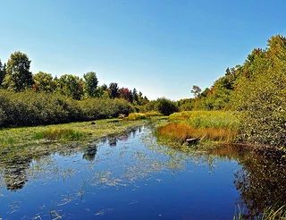
Photo by Aaron Carlson
Rat Lake Swamp and Popple River Headwaters are important as a nearly roadless area in an extensive wetland complex providing interior forest habitat. A series of black spruce and tamarack, mixed conifer, and northern white cedar swamps is drained by Rat Creek into the Popple River. North of the river, the uplands are generally well-drained and most stands are dominated by pole-sized sugar maple hardwoods. Throughout the site, drumlin tops and well-drained uplands are sugar maple dominated while hemlock and white cedar dominate the foot of drumlins and other poorly drained areas. Rat Lake is a hard-water excellent kettle bog situated in the pitted outwash of the Popple River headwaters.
The sedge-sphagnum-ericad mat is well-developed and botanically rich. Flora includes numerous ericaceous species, orchids, sedges, and insectivorous plants. Surrounding the wetland swamps are pockets of old-growth hemlock and sugar maple forest containing a large component of super-canopy white pine. The ground layer is rich, particularly on the drumlin tops, but poorer and dominated by sugar maple seedlings in areas of closed canopy. The shrub layer is poorly developed with American fly honeysuckle the most common. The ground layer includes violets, lycopods, wild sarsaparilla, rosy twisted-stalk, northern beech fern, yellow-blue bead lily, and mountain wood sorrel. Richer soils support wild ginger, bloodroot, blue cohosh, and three species of Botrychium.
South of Rat Lake, a narrow esker winds through the site. Portions are dominated by sugar maple; others by hemlock and white cedar. Very large stumps are still present among the remaining old-growth trees. Of note are the numerous rare plants present, including a state-endangered species. Rare and uncommon bird fauna includes osprey, yellow-bellied flycatcher, gray jay, wood thrush, veery, Philadelphia vireo, Connecticut warbler, Nashville warbler, and black-throated blue warbler. Rat Lake Swamp and Popple River Headwaters are owned by the U.S. Forest Service and were designated a State Natural Area in 2007. This site is also recognized by the Forest Service as an established Research Natural Area.
Very few State Natural Areas have public facilities, but nearly all are open for a variety of recreational activities as indicated below. Generally, there are no picnic areas, restrooms, or other developments. Parking lots or designated parking areas are noted on individual SNA pages and maps. If a developed trail is present, it will normally be noted on the SNA map and/or under the Maps tab. A compass and topographic map or a GPS unit are useful tools for exploring larger, isolated SNAs.
The good majority of SNAs are isolated and have few or no facilities. Some SNAs have vehicle access lanes or parking lots, but their accessibility may vary depending on weather conditions. Parking lots and lanes are not plowed during winter. Hiking trails may be nonexistent or consist of undeveloped footpaths. A GPS unit or compass and a detailed topographic map are useful tools for exploring larger SNAs.
Non-DNR lands
Entrance fees: For non-DNR-owned SNAs, we are unaware of any vehicle or admission fees. However, please contact the landowner for more information.
Hunting and trapping
Other activities
Other allowable activities such as - but not limited to camping, geocaching and bicycling are determined by the landowner. Please contact them directly or visit their websites for details.
Location
Located within the Chequamegon-Nicolet National Forest. Forest County. T38N-R14E, Sections 4-9, 16. T39N-R14E, Sections 29-33. 2,517 acres.
Driving directions
From the intersection of Highway 139 and Settlement Road in Long Lake, go northwest on Settlement Road for 0.2 miles, then north and west on FR 2168 for 3.7 miles, then south on FR 2167 3 miles into the site. To reach the western portion, continue west on FR 2168 for another 3.75 miles, then south on Highway 55 for 2.7 miles, then northeast on FR 2558 0.5, then east on FR 2409 for 0.7 miles to the western boundary.
The DNR's state natural areas program is comprised of lands owned by the state, private conservation organizations, municipalities, other governmental agencies, educational institutions and private individuals. While the majority of SNAs are open to the public, access may vary according to individual ownership policies. Public use restrictions may apply due to public safety, or to protect endangered or threatened species or unique natural features. Lands may be temporarily closed due to specific management activities.
Users are encouraged to contact the landowner for more specific details. The data shown on these maps have been obtained from various sources, and are of varying age, reliability, and resolution. The data may contain errors or omissions and should not be interpreted as a legal representation of legal ownership boundaries. To create your custom map where you can zoom to a specific location, please use the DNR's Mapping Application.
Rat Lake Swamp and Popple River Headwaters are owned by: US Forest Service