Powers Bluff Maple Woods
No. 131
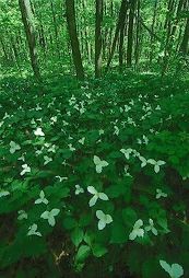
Photo by Thomas A. Meyer/DNR
Powers Bluff Maple Woods features a mature southern mesic forest perched on a 300-foot high monadnock, an isolated remnant hill made of erosion-resistant quartzite. The 1.6 billion-year-old bluff is round-shaped due to the durability of the quartzite, which has resisted erosion. This contrasts with other less durable sandstone bluffs in the area that have weathered parallel to their vertical planes giving them very steep slopes. Dominant trees are sugar maple, yellow birch, and bitternut hickory with scattered red oak, white ash, and basswood.
The understory is quite open and there is little herbaceous ground cover due to the low light levels. Some common species include plantain-leaved sedge, blue cohosh, maidenhair fern, and bloodroot. The forest floor is strewn with boulders and two boulder trains extend southeast and southwest from the bluff suggesting that glacial ice moved over and around the bluff from at least two different directions. On the south end are quartzite outcrops with columbine and common polypody fern. Birds found are typical mesic forest species including least flycatcher, eastern wood pewee, red-eyed vireo, ovenbird, and scarlet tanager. Powers Bluff Maple Woods is owned by Wood County and was designated a State Natural Area in 1976.
Very few State Natural Areas have public facilities, but nearly all are open for various recreational activities as indicated below. Generally, there are no picnic areas, restrooms, or other developments. Parking lots or designated parking areas are noted on individual SNA pages and maps. If a developed trail is present, it will normally be noted on the SNA map and/or under the Maps tab. A compass and topographic map or a GPS unit are useful tools for exploring larger, isolated SNAs.
The good majority of SNAs are isolated and have few or no facilities. Some SNAs have vehicle access lanes or parking lots, but their accessibility may vary depending on weather conditions. Parking lots and lanes are not plowed during winter. Hiking trails may be nonexistent or consist of undeveloped footpaths. A GPS unit or compass and a detailed topographic map are useful tools for exploring larger SNAs.
Non-DNR lands
Entrance fees: For non-DNR-owned SNAs, we are unaware of any vehicle or admission fees. However, please contact the landowner for more information.
Hunting and trapping
Other activities
Other allowable activities such as - but not limited to camping, geocaching and bicycling are determined by the landowner. Please contact them directly or visit their websites for details.
Location
Within Powers Bluff County Park, Wood County. T24N-R4E, Sections 29, 30 E½SE¼. 60 acres.
Driving directions
From the intersection of County Highways N and E on the west side of Arpin, go south on E 1 mile, then west on Bluff Drive 1.1 miles to the entrance to Powers Bluff County Park. The natural area covers the eastern portion of the park.
The DNR's state natural areas program is comprised of lands owned by the state, private conservation organizations, municipalities, other governmental agencies, educational institutions and private individuals. While the majority of SNAs are open to the public, access may vary according to individual ownership policies. Public use restrictions may apply due to public safety, or to protect endangered or threatened species or unique natural features. Lands may be temporarily closed due to specific management activities.
Users are encouraged to contact the landowner for more specific details. The data shown on these maps have been obtained from various sources, and are of varying age, reliability, and resolution. The data may contain errors or omissions and should not be interpreted as a legal representation of legal ownership boundaries. To create your custom map where you can zoom to a specific location, please use the DNR's Mapping Application.
Powers Bluff Maple Woods is owned by: Wood County