Port Wing Boreal Forest
No. 154
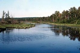
Photo by E. Epstein
Port Wing Boreal Forest encompasses two areas of northern dry-mesic forest on sand spits inland from the present Lake Superior shoreline. The forest has distinct boreal characteristics. Large white and red pines (to 30” diameter) form a canopy over white spruce, balsam fir, red maple, white birch, mountain maple, yellow birch, and white cedar. Recent wind events have blown down some of the largest trees, which were salvaged to reduce the threat of fire. The ground layer contains blueberries, twinflower, yellow blue-bead-lily, large-leaved aster, three-leaved gold-thread, and several club mosses.
Resident birds in the forest are very diverse and include veery, solitary vireo, northern parula, blackburnian warbler, redstart, purple finch, and white-throated sparrow. Between the forested sand spit and the beach to the north is a wetland complex of northern sedge meadow, shrub swamp and bog containing typical bog species such as pitcher plant, sundews, bladderworts, and sedges. Alder thickets are found around the bog. The wetlands are an extension of the estuary of the Flag River, the watercourse that separates the two natural area units. The 20-acre beach and dune complex along the Lake Superior shoreline is dominated by marram grass, blue-joint, Canada wild rye, beach pea, and sand cherry. The beach is used extensively by shorebirds and waterfowl. Port Wing Boreal Forest is owned by the DNR and was designated a State Natural Area in 1979.
Very few State Natural Areas have public facilities, but nearly all are open for various recreational activities as indicated below. Generally, there are no picnic areas, restrooms, or other developments. Parking lots or designated parking areas are noted on individual SNA pages and maps. If a developed trail is present, it will normally be noted on the SNA map and/or under the Maps tab. A compass and topographic map or a GPS unit are useful tools for exploring larger, isolated SNAs.
The good majority of SNAs are isolated and have few or no facilities. Some SNAs have vehicle access lanes or parking lots, but their accessibility may vary depending on weather conditions. Parking lots and lanes are not plowed during winter. Hiking trails may be nonexistent or consist of undeveloped footpaths. A GPS unit or compass and a detailed topographic map are useful tools for exploring larger SNAs.
Entrance fees: Except for Parfrey's Glen, the Cambrian Outlook in the Dells of the Wisconsin River, SNAs within State Parks and some within State Forests, all other DNR-owned SNAs do not have any admission fees. For more information, see Wis. Admin. Code NR 45 [exit DNR]. For non-DNR-owned SNAs, we are unaware of any vehicle or admission fees. However, please contact the landowner for more information.
Allowable activities: DNR-owned land
The activities listed below are generally allowed on all DNR-owned SNA lands. Exceptions to this list of public uses, such as SNAs closed to hunting, are noted above and posted with signs on the property site.
- Hiking
- Fishing
- Cross country skiing
- Hunting
- Trapping
- Scientific research (permit required [PDF])
- Outdoor education
- Wild edibles (What is this?)
- Pets (Rules)
- Wildlife viewing
Prohibited activities: all SNAs
Although a handful of sites allow activities like primitive camping (e.g. Lower Chippewa River on sand bars) or horseback riding (e.g. S. Kettle Moraine), the activities listed below are generally prohibited on DNR-owned SNAs.
- Camping and campfires
- Collecting of animals (other than legally harvested species), non-edible fungi, rocks, minerals, fossils, archaeological artifacts, soil, downed wood, or any other natural material, alive or dead.
- Collecting for scientific research requires a permit issued by the DNR
- Collecting of plants including seeds, roots or other non-edible parts of herbaceous plants such as wildflowers or grasses
- Drones: Flying-related activities, including the use of drones, hang-gliders and model airplanes, are prohibited. Permission may be issued by the SNA Program for the use of drones for educational or research purposes
- Geocaching
- Horseback riding
- Rock climbing
- Vehicles, including bicycles, ATVs, aircraft, and snowmobiles except on trails and roadways designated for their use.
For rules governing state-owned SNAs and other state lands, please consult Chapter NR 45 Wis. Admin. Code [exit DNR].
Location
Bayfield County. T50N-R8W, Sections 20, 21, 28, 29. 467 acres.
Driving directions
For the east unit: from the intersection of County Highway A and State Highway 13 in Port Wing, go east on 13 for about 1.6 miles, then west on Lakeview Road for 0.2 miles, then north on Big Pete Road for about 0.5 miles to Lake Superior. For the west unit: from the intersection of Washington Avenue and 13 in Port Wing, go north on Washington Avenue for 0.6 miles, then west on Quarry Road for about 1 mile, then north on Point Road for 0.25 miles to a parking area.
The DNR's state natural areas program is comprised of lands owned by the state, private conservation organizations, municipalities, other governmental agencies, educational institutions and private individuals. While the majority of SNAs are open to the public, access may vary according to individual ownership policies. Public use restrictions may apply due to public safety, or to protect endangered or threatened species or unique natural features. Lands may be temporarily closed due to specific management activities.
Users are encouraged to contact the landowner for more specific details. The data shown on these maps have been obtained from various sources, and are of varying age, reliability, and resolution. The data may contain errors or omissions and should not be interpreted as a legal representation of legal ownership boundaries. To create your custom map where you can zoom to a specific location, please use the DNR's Mapping Application.
Port Wing Boreal Forest is owned by: Wisconsin DNR