Poppy's Rock
No. 43
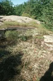
Photo by E. Judziewicz
Poppy's Rock is a Precambrian granitic rock outcrop, sculptured by glaciers that harbors an unusual assemblage of plant species. The rock contains several features created by the scouring of rocks and ice including chatter marks, striations, crescentic gouges, and surface glazing. Vegetation is varied and changes with exposure, inclination, and humus accumulation. Bare rock supports a diverse assemblage of lichens, spikemoss, and mosses. Crevices with accumulated humus harbor many plants with prairie affinities including big and little blue-stem, prairie coreopsis, white wild indigo, bird's-foot violet, prairie alumroot, and lead-plant.
Larger areas of accumulated humus harbor trees. On the upper slopes are red cedar, black oak, and jack and white pines. The north slope is dominated by red maple, big-tooth aspen, and quaking aspen. Shagbark hickory, red maple, and black and white oaks dominate the lower south slope and the base of the outcrop. At the western end is a small area of white pine. Common animals include woodchucks, raccoons, opossums, porcupines, and red foxes. The site has a history of incompatible human use that has resulted in vandalism, litter, and plant theft. Poppy's Rock is owned by Lawrence University and was designated a State Natural Area in 1966.
Very few State Natural Areas have public facilities, but nearly all are open for various recreational activities as indicated below. Generally, there are no picnic areas, restrooms, or other developments. Parking lots or designated parking areas are noted on individual SNA pages and maps. If a developed trail is present, it will normally be noted on the SNA map and/or under the Maps tab. A compass and topographic map or a GPS unit are useful tools for exploring larger, isolated SNAs.
The good majority of SNAs are isolated and have few or no facilities. Some SNAs have vehicle access lanes or parking lots, but their accessibility may vary depending on weather conditions. Parking lots and lanes are not plowed during winter. Hiking trails may be nonexistent or consist of undeveloped footpaths. A GPS unit or compass and a detailed topographic map are useful tools for exploring larger SNAs.
Non-DNR lands
Entrance fees: For non-DNR-owned SNAs, we are unaware of any vehicle or admission fees. However, please contact the landowner for more information.
Hunting and trapping
Other activities
Other allowable activities such as - but not limited to camping, geocaching and bicycling are determined by the landowner. Please contact them directly or visit their websites for details.
Location
Waupaca County. T22N-R14E, Section 26, SE¼NE. 17 acres.
Driving directions
From the intersection of Highways 45 and D (Division St) in New London, go south on D for 3 miles, then west on Manske Road for 1 mile, then north on Bean City Road for 0.5 miles to the east boundary of the site.
The DNR's state natural areas program is comprised of lands owned by the state, private conservation organizations, municipalities, other governmental agencies, educational institutions and private individuals. While the majority of SNAs are open to the public, access may vary according to individual ownership policies. Public use restrictions may apply due to public safety, or to protect endangered or threatened species or unique natural features. Lands may be temporarily closed due to specific management activities.
Users are encouraged to contact the landowner for more specific details. The data shown on these maps have been obtained from various sources, and are of varying age, reliability, and resolution. The data may contain errors or omissions and should not be interpreted as a legal representation of legal ownership boundaries. To create your custom map where you can zoom to a specific location, please use the DNR's Mapping Application.
Poppy's Rock is owned by: Lawrence University