Popple River Corridor
No. 452
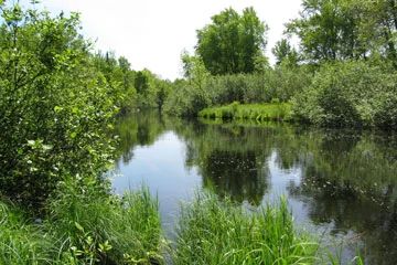
Photo by U.S. Forest Service
Popple River Corridor is a complex of wetlands and adjacent uplands situated along the Popple River. The uplands contain fire-origin white and red pine aged at about 100 years. The understory includes bracken fern, beaked hazelnut, bunchberry, spinulose wood fern, Canada mayflower, big-leaf aster, and northern bush honeysuckle. Also present is a northern wet-mesic forest dominated by late-successional hemlock that contains a significant component of coarse woody debris, den trees, and nurse trees. The ground flora includes Pennsylvania sedge, three-leaved goldthread, downy yellow violet, and large-flowered trillium. A designated wild river, this area of the Popple contains large boulders along its banks and floodplains. Popple River Corridor is owned by the US Forest Service and was designated a State Natural Area in 2007.
Very few State Natural Areas have public facilities, but nearly all are open for various recreational activities as indicated below. Generally, there are no picnic areas, restrooms, or other developments. Parking lots or designated parking areas are noted on individual SNA pages and maps. If a developed trail is present, it will normally be noted on the SNA map and/or under the Maps tab. A compass and topographic map or a GPS unit are useful tools for exploring larger, isolated SNAs.
The good majority of SNAs are isolated and have few or no facilities. Some SNAs have vehicle access lanes or parking lots, but their accessibility may vary depending on weather conditions. Parking lots and lanes are not plowed during winter. Hiking trails may be nonexistent or consist of undeveloped footpaths. A GPS unit or compass and a detailed topographic map are useful tools for exploring larger SNAs.
Non-DNR lands
Entrance fees: For non-DNR-owned SNAs, we are unaware of any vehicle or admission fees. However, please contact the landowner for more information.
Hunting and trapping
Other activities
Other allowable activities such as - but not limited to camping, geocaching and bicycling are determined by the landowner. Please contact them directly or visit their websites for details.
Location
Within the Chequamegon-Nicolet National Forest. Florence County. T38N-R16E, Sections 18, 19, 20; T38N-R15E, Sections 14, 15, 22. 235 acres.
Driving directions
West Section: From the Town of Popple River, take FS2161E to FS2398S to Popple River. Sites are along the river. East Section: From the Town of Popple River take FS2161E to the Morgan Lake Campground area. Sites are along FS2161 and Popple River.
The DNR's state natural areas program is comprised of lands owned by the state, private conservation organizations, municipalities, other governmental agencies, educational institutions and private individuals. While the majority of SNAs are open to the public, access may vary according to individual ownership policies. Public use restrictions may apply due to public safety, or to protect endangered or threatened species or unique natural features. Lands may be temporarily closed due to specific management activities.
Users are encouraged to contact the landowner for more specific details. The data shown on these maps have been obtained from various sources, and are of varying age, reliability, and resolution. The data may contain errors or omissions and should not be interpreted as a legal representation of legal ownership boundaries. To create your custom map where you can zoom to a specific location, please use the DNR's Mapping Application.
Popple River Corridor is owned by: US Forest Service