Pokegama Carnegie Wetlands
No. 516
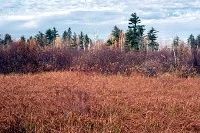
Photo by E. Judziewicz
Situated on level clay flats between the Pokegama and Little Pokegama Rivers, Pokegama Carnegie Wetlands features an extensive mosaic of wetland vegetation containing many rare plant species. A tall complex of shrub wetlands composed of speckled alder and willows has the greatest coverage with small patches of open sedge meadow dominated by coarse leaved sedges and blue joint grass also present. Widely scattered small pools support a variety of emergent and submergent aquatic plant species.
Small "islands" of trees dot the wetland with tamarack, white pine, white spruce, red pine, trembling aspen, and balsam poplar. Of special significance are the numerous populations of rare plants occurring within the wetlands. Many are represented by large or multiple populations throughout the complex and some are not generally widespread within the Lake Superior region. A diversity of animals inhabit the site. Yellow warbler, golden-winged warbler, alder flycatcher, sora, Virginia rail, woodcock, sharp-shinned hawk, and common raven are some of the birds present here. Pokegama Carnegie Wetlands is owned by Douglas County and the DNR. It was designated a State Natural Area in 2006.
Very few State Natural Areas have public facilities, but nearly all are open for various recreational activities as indicated below. Generally, there are no picnic areas, restrooms, or other developments. Parking lots or designated parking areas are noted on individual SNA pages and maps. If a developed trail is present, it will normally be noted on the SNA map and/or under the Maps tab. A compass and topographic map or a GPS unit are useful tools for exploring larger, isolated SNAs.
The good majority of SNAs are isolated and have few or no facilities. Some SNAs have vehicle access lanes or parking lots, but their accessibility may vary depending on weather conditions. Parking lots and lanes are not plowed during winter. Hiking trails may be nonexistent or consist of undeveloped footpaths. A GPS unit or compass and a detailed topographic map are useful tools for exploring larger SNAs.
Hunting and trapping
Allowable activities: DNR-owned land
The activities listed below are generally allowed on all DNR-owned SNA lands. Exceptions to this list of public uses, such as SNAs closed to hunting, are noted above and posted with signs on the property site.
- Hiking
- Fishing
- Cross country skiing
- Hunting
- Trapping
- Scientific research (permit required [PDF])
- Outdoor education
- Wild edibles (What is this?)
- Pets (Rules)
- Wildlife viewing
Prohibited activities: all SNAs
- Camping and campfires
- Collecting of animals (other than legally harvested species), non-edible fungi, rocks, minerals, fossils, archaeological artifacts, soil, downed wood, or any other natural material, alive or dead.
- Collecting for scientific research requires a permit issued by the DNR
- Collecting of plants including seeds, roots or other non-edible parts of herbaceous plants such as wildflowers or grasses
- Geocaching
- Horseback riding
- Rock climbing
- Vehicles, including bicycles, ATVs, aircraft, and snowmobiles except on trails and roadways designated for their use.
For rules governing state-owned SNAs and other state lands, please consult Chapter NR 45 Wis. Admin. Code [exit DNR].
Location
Douglas County. T48N-R14W, Sections 8, 9, 16, 17, 18, 19, 20, 21. 1,516 acres.
Driving directions
From the intersection of State Highway 35 and 105 in Superior, go west on 105 for nearly 2 miles, then south on South Pokegama Road for 0.7 miles. Walk east into the site. To reach the Douglas County Forest SNA, from Highway 105 and County W (Chicago Avenue) in Oliver, go south on W for 2.7 miles, then north on E. Kimmes Road for 0.7 miles. Walk northeast 0.5 miles into the site.
The DNR's state natural areas program is comprised of lands owned by the state, private conservation organizations, municipalities, other governmental agencies, educational institutions and private individuals. While the majority of SNAs are open to the public, access may vary according to individual ownership policies. Public use restrictions may apply due to public safety, or to protect endangered or threatened species or unique natural features. Lands may be temporarily closed due to specific management activities.
Users are encouraged to contact the landowner for more specific details. The data shown on these maps have been obtained from various sources, and are of varying age, reliability, and resolution. The data may contain errors or omissions and should not be interpreted as a legal representation of legal ownership boundaries. To create your custom map where you can zoom to a specific location, please use the DNR's Mapping Application.
Pokegama Carnegie Wetlands is owned by: Douglas County and the Wisconsin DNR