Plum Lake Hemlock Forest
No. 26
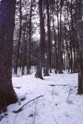
Photo by Thomas A. Meyer/DNR
Plum Lake Hemlock Forest is a near virgin stand of old-growth on rolling topography between Star Lake and Plum Lake. Canopy trees include hemlock, yellow birch, sugar maple, basswood, and paper birch. The presence of large white birch suggests a fire origin with the stand originating around 1810 and succeeding from aspen to pine to hemlock. Selective cutting of white pine, as evidenced by scattered stumps, occurred in the 1880s. Seedlings of birch and red maple are present, but hemlock reproduction is sparse due to overbrowsing by deer, which often use the area as a winter deer yard.
The forest contains substantial numbers of snags and coarse woody debris strewn about the forest floor. Shrubs, though not dense, include mountain maple, American fly honeysuckle, and red elderberry. The understory includes a diversity of herbaceous species including Canada mayflower, shining club-moss, creeping-snowberry, bunchberry, American starflower, pipsissewa, lesser rattlesnake-plantain, and Indian pipe. Nesting birds include red-eyed vireo, black-throated green warbler, blackburnian warbler, northern parula, winter wren, ovenbird, hermit thrush, and veery. Plum Lake Hemlock Forest is owned by the DNR and was designated a State Natural Area in 1953.
Very few State Natural Areas have public facilities, but nearly all are open for various recreational activities as indicated below. Generally, there are no picnic areas, restrooms, or other developments. Parking lots or designated parking areas are noted on individual SNA pages and maps. If a developed trail is present, it will normally be noted on the SNA map and/or under the Maps tab. A compass and topographic map or a GPS unit are useful tools for exploring larger, isolated SNAs.
The good majority of SNAs are isolated and have few or no facilities. Some SNAs have vehicle access lanes or parking lots, but their accessibility may vary depending on weather conditions. Parking lots and lanes are not plowed during winter. Hiking trails may be nonexistent or consist of undeveloped footpaths. A GPS unit or compass and a detailed topographic map are useful tools for exploring larger SNAs.
Entrance fees: Except for Parfrey's Glen, the Cambrian Outlook in the Dells of the Wisconsin River, SNAs within State Parks and some within State Forests, all other DNR-owned SNAs do not have any admission fees. For more information, see Wis. Admin. Code NR 45 [exit DNR]. For non-DNR-owned SNAs, we are unaware of any vehicle or admission fees. However, please contact the landowner for more information.
Allowable activities: DNR-owned land
The activities listed below are generally allowed on all DNR-owned SNA lands. Exceptions to this list of public uses, such as SNAs closed to hunting, are noted above and posted with signs on the property site.
- Hiking
- Fishing
- Cross country skiing
- Hunting
- Trapping
- Scientific research (permit required [PDF])
- Outdoor education
- Wild edibles (What is this?)
- Pets (Rules)
- Wildlife viewing
Prohibited activities: all SNAs
Although a handful of sites allow activities like primitive camping (e.g. Lower Chippewa River on sand bars) or horseback riding (e.g. S. Kettle Moraine), the activities listed below are generally prohibited on DNR-owned SNAs.
- Camping and campfires
- Collecting of animals (other than legally harvested species), non-edible fungi, rocks, minerals, fossils, archaeological artifacts, soil, downed wood, or any other natural material, alive or dead.
- Collecting for scientific research requires a permit issued by the DNR
- Collecting of plants including seeds, roots or other non-edible parts of herbaceous plants such as wildflowers or grasses
- Drones: Flying-related activities, including the use of drones, hang-gliders and model airplanes, are prohibited. Permission may be issued by the SNA Program for the use of drones for educational or research purposes
- Geocaching
- Horseback riding
- Rock climbing
- Vehicles, including bicycles, ATVs, aircraft, and snowmobiles except on trails and roadways designated for their use.
For rules governing state-owned SNAs and other state lands, please consult Chapter NR 45 Wis. Admin. Code [exit DNR].
Location
Within Northern Highland-American Legion State Forest, Vilas County. T41N-R8E, Sections 16, 21, 22, 27, 28. 747 acres.
Driving directions
From the north junction of State Highway 155 and County Highway N in Sayner, go west on N 2.1 miles, then north 4.2 miles on Razorback Road, then east 1 mile on Rearing Pond Road, then south at the T intersection 0.5 miles to the western boundary. Park along the road and walk southeast into the site. To access the eastern portion, from the south junction of 155 and N in Sayner, go east and north on N for 4.8 miles, then southwest on Tramper's Trail (Hook Lake Road) for 0.8 miles to a parking area.
The DNR's state natural areas program is comprised of lands owned by the state, private conservation organizations, municipalities, other governmental agencies, educational institutions and private individuals. While the majority of SNAs are open to the public, access may vary according to individual ownership policies. Public use restrictions may apply due to public safety, or to protect endangered or threatened species or unique natural features. Lands may be temporarily closed due to specific management activities.
Users are encouraged to contact the landowner for more specific details. The data shown on these maps have been obtained from various sources, and are of varying age, reliability, and resolution. The data may contain errors or omissions and should not be interpreted as a legal representation of legal ownership boundaries. To create your custom map where you can zoom to a specific location, please use the DNR's Mapping Application.
Plum Lake Hemlock Forest is owned by: Wisconsin DNR