Pleasant Valley Conservancy
No. 551
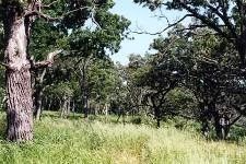
Photo by T. Brock
Located in the Driftless Area of southwest Wisconsin, Pleasant Valley Conservancy sits on a long narrow ridge that runs almost due east/west, with steep hillsides facing both north and south. The site contains a nearly complete range of southern Wisconsin natural community types including oak woodland, oak savanna, dry and wet prairie, sedge meadow, shrub-carr, open marsh, and spring complex. The steep south-facing ridge supports several prairie remnants, which are now thriving after intensive management began in 1995.
Plant species include big bluestem, little bluestem, Indian grass, side-oats grama, wood betony, bird's-foot violet, purple prairie clover, and wood sorrel. The oak savannas, primarily on the ridge top, contain numerous large, open-grown bur and white oaks with many being over 150 years old. The savanna supports numerous grass, sedge, and forb species including a state-endangered plant that re-appeared after restoration and prescribed burning began. Other plants include silky rye, bottlebrush grass, ear-leaved brome, leadplant, large-flowered yellow false foxglove, Canada milk vetch, Illinois tick-trefoil, alum root, shooting star, and spiderwort. The cooler north-facing slope is predominantly oak woodland with red oak, basswood, hackberry, butternut, yellow bud hickory, and red maple.
The woodland contains a good variety of spring ephemerals such as bloodroot, Jacob's-ladder, large-flowered bellwort, yellow lady's-slipper orchid, large white trillium, and Dutchman's breeches. The savanna and oak woodland support a diversity of bird species which include the red-headed woodpecker, a declining bird species of conservation concern. Other birds include blue-gray gnatcatcher, eastern wood pewee, tufted titmouse, eastern bluebird, yellow-throated vireo, scarlet tanager, and black-billed cuckoo. Also present is the spring-fed Pleasant Valley Creek, which flows through the wetland and into East Blue Mounds Creek. Pleasant Valley Conservancy is owned in part by The Prairie Enthusiasts and by Tom and Kathie Brock with management support from the Savanna Oak Foundation, Inc. It was designated a State Natural Area in 2007.
Very few State Natural Areas have public facilities, but nearly all are open for various recreational activities as indicated below. Generally, there are no picnic areas, restrooms, or other developments. Parking lots or designated parking areas are noted on individual SNA pages and maps. If a developed trail is present, it will normally be noted on the SNA map and/or under the Maps tab. A compass and topographic map or a GPS unit are useful tools for exploring larger, isolated SNAs.
The good majority of SNAs are isolated and have few or no facilities. Some SNAs have vehicle access lanes or parking lots, but their accessibility may vary depending on weather conditions. Parking lots and lanes are not plowed during winter. Hiking trails may be nonexistent or consist of undeveloped footpaths. A GPS unit or compass and a detailed topographic map are useful tools for exploring larger SNAs.
Non-DNR lands
Entrance fees: For non-DNR-owned SNAs, we are unaware of any vehicle or admission fees. However, please contact the landowner for more information.
Hunting and trapping
Note: Hunting is by permission only. For more information visit: Pleasant Valley Conservancy [exit DNR].
Other activities
Other allowable activities such as - but not limited to camping, geocaching and bicycling are determined by the landowner. Please contact them directly or visit their websites for details.
Location
Dane County. T7N-R6E, Sections 5, 8. 143 acres.
Driving directions
Take US Highway 14 to the Village of Black Earth. Go south on County F through the village and follow F for nearly 3.7 miles. Turn east (left) on Pleasant Valley Road and go 0.75 miles to the entrance of the preserve. Park along the road facing in. A hiking trail loops through the site.
The DNR's state natural areas program is comprised of lands owned by the state, private conservation organizations, municipalities, other governmental agencies, educational institutions and private individuals. While the majority of SNAs are open to the public, access may vary according to individual ownership policies. Public use restrictions may apply due to public safety, or to protect endangered or threatened species or unique natural features. Lands may be temporarily closed due to specific management activities.
Users are encouraged to contact the landowner for more specific details. The data shown on these maps have been obtained from various sources, and are of varying age, reliability, and resolution. The data may contain errors or omissions and should not be interpreted as a legal representation of legal ownership boundaries. To create your custom map where you can zoom to a specific location, please use the DNR's Mapping Application.
Pleasant Valley Conservancy is owned by: Prairie Enthusiasts and Private