Plainfield Tunnel Channel Lakes
No. 226
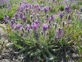
Photo by Darcy Kind
The Plainfield Tunnel Channel Lakes provide specialized habitat for one of the rare members of the bean family which grows here and nowhere else. It is adapted to the sandy shores of shallow seepage lakes whose shorelines fluctuate widely over months or years depending on rainfall and drought patterns. When the shore is exposed, seeds in the seed bank germinate, grow, flower, and drop seeds. The plant requires open, sunny habitat and relies on periodic flooding to kill shade-producing trees that invade the shoreline in dry years. The plant survives inundation - up to years at a time - by persisting in the lake bottom's seed bank until the water levels drop. Protected are the shorelines of three lakes in a string of 13 lakes and ponds lying in a "tunnel channel" created by a meltwater river flowing beneath the glacial ice. The lake basins were created from buried blocks of ice left behind when the tunnel collapsed. Why the rare plant is endemic to Central Wisconsin is unknown but it may be related to the effects of the glacial lake, which once covered the area 10,000 years ago. While shading and competition by trees and other plants are the primary natural threats, trampling by humans and disturbance from off-road vehicles pose far more serious threats to these sensitive plants. Plainfield Tunnel Channel Lakes are owned by the DNR and were designated a State Natural Area in 1990.
Very few State Natural Areas have public facilities, but nearly all are open for various recreational activities as indicated below. Generally, there are no picnic areas, restrooms, or other developments. Parking lots or designated parking areas are noted on individual SNA pages and maps. If a developed trail is present, it will normally be noted on the SNA map and/or under the Maps tab. A compass and topographic map or a GPS unit are useful tools for exploring larger, isolated SNAs.
The good majority of SNAs are isolated and have few or no facilities. Some SNAs have vehicle access lanes or parking lots, but their accessibility may vary depending on weather conditions. Parking lots and lanes are not plowed during winter. Hiking trails may be nonexistent or consist of undeveloped footpaths. A GPS unit or compass and a detailed topographic map are useful tools for exploring larger SNAs.
Entrance fees: Except for Parfrey's Glen, the Cambrian Outlook in the Dells of the Wisconsin River, SNAs within State Parks and some within State Forests, all other DNR-owned SNAs do not have any admission fees. For more information, see Wis. Admin. Code NR 45 [exit DNR]. For non-DNR-owned SNAs, we are unaware of any vehicle or admission fees. However, please contact the landowner for more information.
Allowable activities: DNR-owned land
The activities listed below are generally allowed on all DNR-owned SNA lands. Exceptions to this list of public uses, such as SNAs closed to hunting, are noted above and posted with signs on the property site.
- Hiking
- Fishing
- Cross country skiing
- Hunting
- Trapping
- Scientific research (permit required [PDF])
- Outdoor education
- Wild edibles (What is this?)
- Pets (Rules)
- Wildlife viewing
Prohibited activities: all SNAs
Although a handful of sites allow activities like primitive camping (e.g. Lower Chippewa River on sand bars) or horseback riding (e.g. S. Kettle Moraine), the activities listed below are generally prohibited on DNR-owned SNAs.
- Camping and campfires
- Collecting of animals (other than legally harvested species), non-edible fungi, rocks, minerals, fossils, archaeological artifacts, soil, downed wood, or any other natural material, alive or dead.
- Collecting for scientific research requires a permit issued by the DNR
- Collecting of plants including seeds, roots or other non-edible parts of herbaceous plants such as wildflowers or grasses
- Drones: Flying-related activities, including the use of drones, hang-gliders and model airplanes, are prohibited. Permission may be issued by the SNA Program for the use of drones for educational or research purposes
- Geocaching
- Horseback riding
- Rock climbing
- Vehicles, including bicycles, ATVs, aircraft, and snowmobiles except on trails and roadways designated for their use.
For rules governing state-owned SNAs and other state lands, please consult Chapter NR 45 Wis. Admin. Code [exit DNR].
Location
Waushara County. T20N-R9E, Sections 16, 17, 18, 21. 192 acres.
Driving directions
From the intersection of State Highway 73 and County Highway BB on the east side of Plainfield, go east and south on 73 0.85 miles to a parking area west of the road.
The DNR's state natural areas program is comprised of lands owned by the state, private conservation organizations, municipalities, other governmental agencies, educational institutions and private individuals. While the majority of SNAs are open to the public, access may vary according to individual ownership policies. Public use restrictions may apply due to public safety, or to protect endangered or threatened species or unique natural features. Lands may be temporarily closed due to specific management activities.
Users are encouraged to contact the landowner for more specific details. The data shown on these maps have been obtained from various sources, and are of varying age, reliability, and resolution. The data may contain errors or omissions and should not be interpreted as a legal representation of legal ownership boundaries. To create your custom map where you can zoom to a specific location, please use the DNR's Mapping Application.
Plainfield Tunnel Channel Lakes is owned by: Wisconsin DNR
Management objectives and prescriptions
Read Interim Forest Management Plan [PDF] for details.