Pirus Road Swamp
No. 494
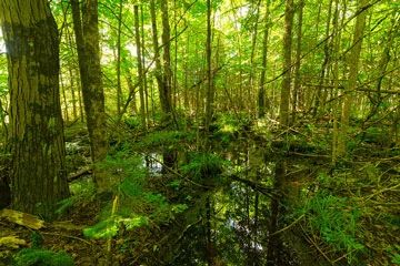
Photo by Josh Mayer
Pirus Road Swamp features a mosaic of forested wetland communities including northern wet-mesic forest, black ash swamp, and tamarack fen. The semi-open tamarack swamp grades to white cedar or black ash to the north, west, and east. Situated at the base of the ice-marginal position of the Perkinstown End Moraine, the hydrological conditions appear to be influencing the site's species composition, which includes an exceptionally rich ground flora as compared to other swamps in the vicinity. Species include royal fern, swamp saxifrage, dwarf red raspberry, bunchberry, and skunk cabbage. The uplands contain a northern mesic forest dominated by hemlock with yellow birch, and super-canopy white pine. Numerous small tamarack bogs in kettle depressions are punctuated throughout. Also present is a wet-mesic forest dominated by cedar with hemlock and white spruce. Pirus Road Swamp is owned by the US Forest Service and was designated a State Natural Area in 2007.
Very few State Natural Areas have public facilities, but nearly all are open for various recreational activities as indicated below. Generally, there are no picnic areas, restrooms, or other developments. Parking lots or designated parking areas are noted on individual SNA pages and maps. If a developed trail is present, it will normally be noted on the SNA map and/or under the Maps tab. A compass and topographic map or a GPS unit are useful tools for exploring larger, isolated SNAs.
The good majority of SNAs are isolated and have few or no facilities. Some SNAs have vehicle access lanes or parking lots, but their accessibility may vary depending on weather conditions. Parking lots and lanes are not plowed during winter. Hiking trails may be nonexistent or consist of undeveloped footpaths. A GPS unit or compass and a detailed topographic map are useful tools for exploring larger SNAs.
Non-DNR lands
Entrance fees: For non-DNR-owned SNAs, we are unaware of any vehicle or admission fees. However, please contact the landowner for more information.
Hunting and trapping
Other activities
Other allowable activities such as - but not limited to camping, geocaching and bicycling are determined by the landowner. Please contact them directly or visit their websites for details.
Location
Within the Chequamegon-Nicolet National Forest, Taylor County. T31N-R2W, Section 35. 187 acres.
Driving directions
From the junction of Highways 13 and 64 in Medford to west on 64 14.4 miles to Forest Road 608 (may be unmarked) road on the north (this is 0.2 miles west of the junction of 64 and Coyote Dr). Park and walk (or drive, if able) north about 0.5 miles. The southwest corner of the natural area lies 0.2 miles to the northeast. Another access is from the north. From the junction of 64 and Pirus Road, go north on Pirus Road 1.8 miles to Forest Road 607 and walk/drive about 1.5 miles southwest to within 0.25 miles of the northern boundary of the natural area, then travel off-trail south to the site. A map, air photo, compass and/or GPS unit is recommended to navigate to this site given the confusing network of forest roads.
The DNR's state natural areas program is comprised of lands owned by the state, private conservation organizations, municipalities, other governmental agencies, educational institutions and private individuals. While the majority of SNAs are open to the public, access may vary according to individual ownership policies. Public use restrictions may apply due to public safety, or to protect endangered or threatened species or unique natural features. Lands may be temporarily closed due to specific management activities.
Users are encouraged to contact the landowner for more specific details. The data shown on these maps have been obtained from various sources, and are of varying age, reliability, and resolution. The data may contain errors or omissions and should not be interpreted as a legal representation of legal ownership boundaries. To create your custom map where you can zoom to a specific location, please use the DNR's Mapping Application.
Pirus Road Swamp is owned by: US Forest Service