Pine Hollow
No. 45
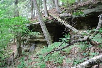
Photo by Joshua Mayer
Pine Hollow features a narrow, heavily wooded stream gorge with sheer cliffs and rock outcroppings of sandstone and quartzite cut into the Baraboo Hills. Differential erosion has cut a ravine about 300’ deep with cliff walls up to 80’ high. The complex slope and variety of exposures have resulted in a rich flora of more than 500 species. Hemlocks of all size classes occupy the steep, moist ravine walls while yellow birch and red maple are found on the lower slopes. A few large white pines grow on the near vertical sandstone cliffs. On the rocky uplands grow red and white oaks with black oaks present near the drier bluffs and a prairie opening is found on top of a west-facing bluff with columbine, yellow star-grass, and shooting-star with abundant Pennsylvania sedge and early oak sedge near rocks.
On the upper slopes grow various ericads (plants of the Heath family) including huckleberry and trailing arbutus with an abundance of moccasin flowers in late spring. Also present are moist shaded cliffs that harbor a wide variety of ferns, moss, and liverworts including the rare sword moss, pincushion moss, and Sullivant’s cool wort. Toward the lower, south end of the hollow is an open sedge meadow with turtlehead, manna grass, ferns, and a state-threatened sedge. A diverse breeding bird community is present including Canada warbler, Louisiana waterthrush, and golden-winged warbler. Pine Hollow is owned by the Wisconsin Chapter of The Nature Conservancy and was designated a State Natural Area in 1966.
Very few State Natural Areas have public facilities, but nearly all are open for various recreational activities as indicated below. Generally, there are no picnic areas, restrooms, or other developments. Parking lots or designated parking areas are noted on individual SNA pages and maps. If a developed trail is present, it will normally be noted on the SNA map and/or under the Maps tab. A compass and topographic map or a GPS unit are useful tools for exploring larger, isolated SNAs.
The good majority of SNAs are isolated and have few or no facilities. Some SNAs have vehicle access lanes or parking lots, but their accessibility may vary depending on weather conditions. Parking lots and lanes are not plowed during winter. Hiking trails may be nonexistent or consist of undeveloped footpaths. A GPS unit or compass and a detailed topographic map are useful tools for exploring larger SNAs.
Non-DNR lands
Entrance fees: For non-DNR-owned SNAs, we are unaware of any vehicle or admission fees. However, please contact the landowner for more information.
Hunting and trapping
For hunting opportunities on Nature Conservancy land, visit The Nature Conservancy's Deer Management [exit DNR].
Other activities
Other allowable activities such as - but not limited to camping, geocaching and bicycling are determined by the landowner. Please contact them directly or visit their websites for details.
Location
Sauk County. T10N-R5E, Sections 3, 4, 5, 8, 9. 335 acres.
Driving directions
From the junction of County Highways PF and C in Leland, go east on C for 2.9 miles, then north on Pine Hollow Road for 1.5 miles. Park on the road shoulder and walk due west into the preserve. Be advised that there are no hiking trails, and the slope down into the hollow is steep and rocky.
The DNR's state natural areas program is comprised of lands owned by the state, private conservation organizations, municipalities, other governmental agencies, educational institutions and private individuals. While the majority of SNAs are open to the public, access may vary according to individual ownership policies. Public use restrictions may apply due to public safety, or to protect endangered or threatened species or unique natural features. Lands may be temporarily closed due to specific management activities.
Users are encouraged to contact the landowner for more specific details. The data shown on these maps have been obtained from various sources, and are of varying age, reliability, and resolution. The data may contain errors or omissions and should not be interpreted as a legal representation of legal ownership boundaries. To create your custom map where you can zoom to a specific location, please use the DNR's Mapping Application.
Pine Hollow is owned by: The Nature Conservancy