Perkinstown Hemlocks
No. 469
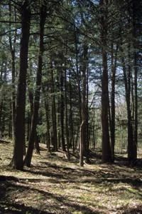
Photo by Thomas A. Meyer/DNR
Located within the Perkinstown End Moraine Land type of ridges, knobs, kettle depressions, and eskers, this site features a forest of medium to large-sized hemlock, yellow birch, and sugar maple. Super-canopy white pines occur locally. Other canopy associates are paper birch, red maple, white ash, and basswood. The forest contains many structural features characteristic of older forests. Saplings are primarily sugar maple, balsam fir, and occasionally white ash. Hemlock saplings are absent or very local, although seedling hemlocks do occur.
The shrub layer is sparse and composed of beaked hazelnut, American fly honeysuckle, mountain maple, red elderberry, and leatherwood. Representative herbs include Canada mayflower, sweet cicely, intermediate wood fern, bristly club-moss, northern tree club-moss, and shining club-moss. Moister areas support mountain wood sorrel, three-leaved goldthread, yellow-blue bead lily, and bunchberry. A tiny gravel-bottomed stream with clear but humus-stained water runs through the site draining surrounding stands of black ash swamp forest. Perkinstown Hemlocks is owned by the US Forest Service and was designated a State Natural Area in 2007.
Very few State Natural Areas have public facilities, but nearly all are open for various recreational activities as indicated below. Generally, there are no picnic areas, restrooms, or other developments. Parking lots or designated parking areas are noted on individual SNA pages and maps. If a developed trail is present, it will normally be noted on the SNA map and/or under the Maps tab. A compass and topographic map or a GPS unit are useful tools for exploring larger, isolated SNAs.
The good majority of SNAs are isolated and have few or no facilities. Some SNAs have vehicle access lanes or parking lots, but their accessibility may vary depending on weather conditions. Parking lots and lanes are not plowed during winter. Hiking trails may be nonexistent or consist of undeveloped footpaths. A GPS unit or compass and a detailed topographic map are useful tools for exploring larger SNAs.
Non-DNR lands
Entrance fees: For non-DNR-owned SNAs, we are unaware of any vehicle or admission fees. However, please contact the landowner for more information.
Hunting and trapping
Other activities
Other allowable activities such as - but not limited to camping, geocaching and bicycling are determined by the landowner. Please contact them directly or visit their websites for details.
Location
Within the Chequamegon-Nicolet National Forest. Taylor County. T31N-R2W, Sections 15, 16, 21, 22. 102 acres.
Driving directions
From Perkinstown, go south and west on FR 121 for approximately 2.25 miles, then south on FR 199 for nearly 2 miles, then east on FR 554 for 1.2 miles. The site lies north of the road.
The DNR's state natural areas program is comprised of lands owned by the state, private conservation organizations, municipalities, other governmental agencies, educational institutions and private individuals. While the majority of SNAs are open to the public, access may vary according to individual ownership policies. Public use restrictions may apply due to public safety, or to protect endangered or threatened species or unique natural features. Lands may be temporarily closed due to specific management activities.
Users are encouraged to contact the landowner for more specific details. The data shown on these maps have been obtained from various sources, and are of varying age, reliability, and resolution. The data may contain errors or omissions and should not be interpreted as a legal representation of legal ownership boundaries. To create your custom map where you can zoom to a specific location, please use the DNR's Mapping Application.
Perkinstown Hemlocks is owned by: US Forest Service