Peninsula Niagara Escarpment
No. 688
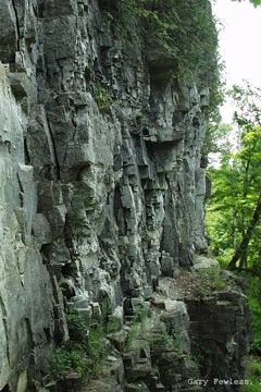
Photo by Gary Fewless
Peninsula Niagara Escarpment features extensive exposures of the Niagara Escarpment, a 650-mile sickle-shaped cuesta, or bedrock ridge, that runs from the northeastern U.S., across portions of southeastern Canada, and then southward north and west of Lake Michigan to southeastern Wisconsin. The Escarpment portion occurring in Ontario Canada has been designated as a UNESCO World Biosphere Reserve.
Formed over millions of years through differential erosion, the Escarpment bedrock is primarily dolomite that originated from accumulated sediments of an ancient sea some 405-425 million years ago during the Silurian Period of the Paleozoic Era. A cap of erosion-resistant dolomite overlies weaker, more easily eroded and weathered shale. Through time, the soft rocks weather and erode through the action of water and freezing and thawing cycles. The gradual removal of the softer rocks undercuts the resistant cap, leaving a series of cliffs - the Niagara Escarpment.
In Wisconsin, the Escarpment extends for over 230 miles, from Rock Island off the Door Peninsula, then south to Waukesha and Milwaukee counties. Glacial processes have also impacted the Escarpment leading to differential erosion, which has greatly influenced its ecological attributes creating unique microhabitats that support many specialized species. One example is the presence of the karst features of the bedrock that allow organic matter to accumulate.
Cold air and sometimes water move through the fractured rock creating areas known as Talus slopes that provide habitat for a diverse group of rare terrestrial snails that have been present since the last Ice Age. The snails have restricted ranges, limited dispersal ability, very specific biotic and abiotic habitat requirements, and are vulnerable to management activities that alter temperature, moisture, and/or food supplies. At the top of the Escarpment is a mixed upland forest dominated by northern white cedar, white birch, and sugar maple. Peninsula Park Niagara Escarpment is owned by the DNR and was designated a State Natural Area in 2018.
Very few State Natural Areas have public facilities, but nearly all are open for various recreational activities as indicated below. Generally, there are no picnic areas, restrooms, or other developments. Parking lots or designated parking areas are noted on individual SNA pages and maps. If a developed trail is present, it will normally be noted on the SNA map and/or under the Maps tab. A compass and topographic map or a GPS unit are useful tools for exploring larger, isolated SNAs.
The good majority of SNAs are isolated and have few or no facilities. Some SNAs have vehicle access lanes or parking lots, but their accessibility may vary depending on weather conditions. Parking lots and lanes are not plowed during winter. Hiking trails may be nonexistent or consist of undeveloped footpaths. A GPS unit or compass and a detailed topographic map are useful tools for exploring larger SNAs.
Entrance fees: Except for Parfrey's Glen, the Cambrian Outlook in the Dells of the Wisconsin River, SNAs within State Parks and some within State Forests, all other DNR-owned SNAs do not have any admission fees. For more information, see Wis. Admin. Code NR 45 [exit DNR]. For non-DNR-owned SNAs, we are unaware of any vehicle or admission fees. However, please contact the landowner for more information.
Allowable activities: DNR-owned land
The activities listed below are generally allowed on all DNR-owned SNA lands. Exceptions to this list of public uses, such as SNAs closed to hunting, are noted above and posted with signs on the property site.
- Hiking
- Fishing
- Cross country skiing
- Hunting
- Trapping
- Scientific research (permit required [PDF])
- Outdoor education
- Wild edibles (What is this?)
- Pets (Rules)
- Wildlife viewing
Prohibited activities: all SNAs
Although a handful of sites allow activities like primitive camping (e.g. Lower Chippewa River on sand bars) or horseback riding (e.g. S. Kettle Moraine), the activities listed below are generally prohibited on DNR-owned SNAs.
- Camping and campfires
- Collecting of animals (other than legally harvested species), non-edible fungi, rocks, minerals, fossils, archaeological artifacts, soil, downed wood, or any other natural material, alive or dead.
- Collecting for scientific research requires a permit issued by the DNR
- Collecting of plants including seeds, roots or other non-edible parts of herbaceous plants such as wildflowers or grasses
- Drones: Flying-related activities, including the use of drones, hang-gliders and model airplanes, are prohibited. Permission may be issued by the SNA Program for the use of drones for educational or research purposes
- Geocaching
- Horseback riding
- Rock climbing
- Vehicles, including bicycles, ATVs, aircraft, and snowmobiles except on trails and roadways designated for their use.
For rules governing state-owned SNAs and other state lands, please consult Chapter NR 45 Wis. Admin. Code [exit DNR].
Location
Within Peninsula State Park, Door County. T31N-R27E, Sections 14, 15, 16, 20, 21. 242 acres.
Driving directions
From Fish Creek, go north on State Highway 42 about 0.5 mile to the south entrance to Peninsula State Park. Follow Shore Road north into the park and obtain a park map at the office. Portions of the escarpment are accessible via the Hidden Bluff Trail or the Sunset bike route. A Wisconsin State Park sticker must be displayed on all vehicles entering the park.
The DNR's state natural areas program is comprised of lands owned by the state, private conservation organizations, municipalities, other governmental agencies, educational institutions and private individuals. While the majority of SNAs are open to the public, access may vary according to individual ownership policies. Public use restrictions may apply due to public safety, or to protect endangered or threatened species or unique natural features. Lands may be temporarily closed due to specific management activities.
Users are encouraged to contact the landowner for more specific details. The data shown on these maps have been obtained from various sources, and are of varying age, reliability, and resolution. The data may contain errors or omissions and should not be interpreted as a legal representation of legal ownership boundaries. To create your custom map where you can zoom to a specific location, please use the DNR's Mapping Application.
Peninsula Niagara Escarpment is owned by: Wisconsin DNR