Pea Creek Sedge Meadow
No. 315
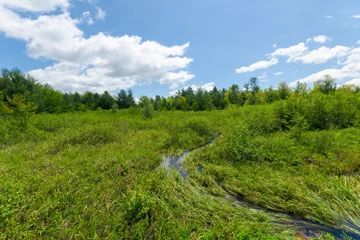
Photo by Josh Mayer
Pea Creek Sedge Meadow features a large, undisturbed acid meadow that is the headwaters of Pea Creek, a tributary of the Eau Claire River. Dominant plants include few-seeded sedge, beaked sedge, tussock sedge, blue-joint grass, bog birch, and leather-leaf over a patchy cover of sphagnum. Other characteristic herbs and shrubs are steeplebush, bog willow, swamp candles, marsh fern, wild iris, swamp loosestrife, northern bog goldenrod, and swamp dewberry.
The meadow is more open along the edges and becomes brushy toward the center. Patches of tamarack are also present, mostly near the eastern margins of the wetland. A tall shrub zone of speckled alder, black chokeberry, mountain holly, and common winterberry occupies a portion of the upland-wetland interface. Several small stands of white pine-red maple forest are present along the edges of the meadow while uplands are sandy and mostly second-growth white pine, oak, aspen, and birch. Pea Creek Sedge Meadow is owned by Eau Claire County and was designated a State Natural Area in 1996.
Very few State Natural Areas have public facilities, but nearly all are open for various recreational activities as indicated below. Generally, there are no picnic areas, restrooms, or other developments. Parking lots or designated parking areas are noted on individual SNA pages and maps. If a developed trail is present, it will normally be noted on the SNA map and/or under the Maps tab. A compass and topographic map or a GPS unit are useful tools for exploring larger, isolated SNAs.
The good majority of SNAs are isolated and have few or no facilities. Some SNAs have vehicle access lanes or parking lots, but their accessibility may vary depending on weather conditions. Parking lots and lanes are not plowed during winter. Hiking trails may be nonexistent or consist of undeveloped footpaths. A GPS unit or compass and a detailed topographic map are useful tools for exploring larger SNAs.
Non-DNR lands
Entrance fees: For non-DNR-owned SNAs, we are unaware of any vehicle or admission fees. However, please contact the landowner for more information.
Hunting and trapping
Other activities
Other allowable activities such as - but not limited to camping, geocaching and bicycling are determined by the landowner. Please contact them directly or visit their websites for details.
Location
Within Eau Claire County Forest, Eau Claire County. T25N-R5W, Sections 3, 4. 200 acres.
Driving directions
From the intersection of Highways 12 and H in Fairchild, go north on H 5.2 miles and park along the road (about 0.25 miles past Highway M). The open sedge meadow lies west of the highway.
The DNR's state natural areas program is comprised of lands owned by the state, private conservation organizations, municipalities, other governmental agencies, educational institutions and private individuals. While the majority of SNAs are open to the public, access may vary according to individual ownership policies. Public use restrictions may apply due to public safety, or to protect endangered or threatened species or unique natural features. Lands may be temporarily closed due to specific management activities.
Users are encouraged to contact the landowner for more specific details. The data shown on these maps have been obtained from various sources, and are of varying age, reliability, and resolution. The data may contain errors or omissions and should not be interpreted as a legal representation of legal ownership boundaries. To create your custom map where you can zoom to a specific location, please use the DNR's Mapping Application.
Pea Creek Sedge Meadow is owned by: Eau Claire County