Patterson Hemlocks
No. 216
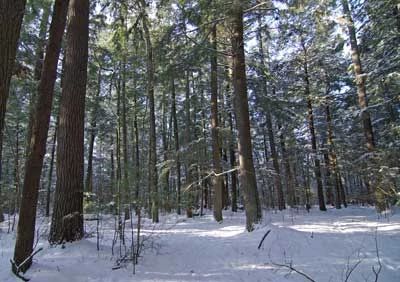
Photo by Thomas A. Meyer/DNR
Patterson Hemlocks protects a large block of old-growth northern mesic forest on an isthmus between Clear and Fuller Lakes with large hemlock, yellow birch, and white pine throughout. The tract contains examples of all stages of development in a hemlock-hardwood forest from areas of dense hemlock saplings to a mature stand of hemlock with scattered clumps of supercanopy white pine. The hemlock and yellow birch are in the 15-30 inch size class while some white pines are greater than three feet in diameter (dbh) and 120 feet high.
The eastern portion of the site is relatively level but becomes more rolling toward the west. Many dead-standing trees, a very thick duff layer, and rotting logs on the ground accentuate the stand's old-growth appearance. Understory shrubs include mountain maple and beaked hazelnut. Intermediate wood fern and shining club moss dominate the herbaceous layer, and large patches of mountain wood sorrel are scattered throughout. Other plants include sharp-lobed hepatica, three-leaved gold-thread, bunchberry, and large-leaved aster. Several soft-water ephemeral pools contain blue-joint grass, common bladderwort, water smartweed, coon's-tail, rattlesnake grass, and wool grass. Nesting birds include black-throated green and blackburnian warblers, veery, and pileated woodpeckers. Patterson Hemlocks is owned by the DNR and was designated a State Natural Area in 1987.
Very few State Natural Areas have public facilities, but nearly all are open for various recreational activities as indicated below. Generally, there are no picnic areas, restrooms, or other developments. Parking lots or designated parking areas are noted on individual SNA pages and maps. If a developed trail is present, it will normally be noted on the SNA map and/or under the Maps tab. A compass and topographic map or a GPS unit are useful tools for exploring larger, isolated SNAs.
The good majority of SNAs are isolated and have few or no facilities. Some SNAs have vehicle access lanes or parking lots, but their accessibility may vary depending on weather conditions. Parking lots and lanes are not plowed during winter. Hiking trails may be nonexistent or consist of undeveloped footpaths. A GPS unit or compass and a detailed topographic map are useful tools for exploring larger SNAs.
Entrance fees: Except for Parfrey's Glen, the Cambrian Outlook in the Dells of the Wisconsin River, SNAs within State Parks and some within State Forests, all other DNR-owned SNAs do not have any admission fees. For more information, see Wis. Admin. Code NR 45 [exit DNR]. For non-DNR-owned SNAs, we are unaware of any vehicle or admission fees. However, please contact the landowner for more information.
Allowable activities: DNR-owned land
The activities listed below are generally allowed on all DNR-owned SNA lands. Exceptions to this list of public uses, such as SNAs closed to hunting, are noted above and posted with signs on the property site.
- Hiking
- Fishing
- Cross country skiing
- Hunting
- Trapping
- Scientific research (permit required [PDF])
- Outdoor education
- Wild edibles (What is this?)
- Pets (Rules)
- Wildlife viewing
Prohibited activities: all SNAs
Although a handful of sites allow activities like primitive camping (e.g. Lower Chippewa River on sand bars) or horseback riding (e.g. S. Kettle Moraine), the activities listed below are generally prohibited on DNR-owned SNAs.
- Camping and campfires
- Collecting of animals (other than legally harvested species), non-edible fungi, rocks, minerals, fossils, archaeological artifacts, soil, downed wood, or any other natural material, alive or dead.
- Collecting for scientific research requires a permit issued by the DNR
- Collecting of plants including seeds, roots or other non-edible parts of herbaceous plants such as wildflowers or grasses
- Drones: Flying-related activities, including the use of drones, hang-gliders and model airplanes, are prohibited. Permission may be issued by the SNA Program for the use of drones for educational or research purposes
- Geocaching
- Horseback riding
- Rock climbing
- Vehicles, including bicycles, ATVs, aircraft, and snowmobiles except on trails and roadways designated for their use.
For rules governing state-owned SNAs and other state lands, please consult Chapter NR 45 Wis. Admin. Code [exit DNR].
Location
Oneida County. T39N-R4E, Section 3 NE¼, E½NW¼. T40-R4E, Sections 34, 35. 304 acres.
Driving directions
From the intersection of U.S. Highway 51 and State Highway 70 in Woodruff, go west on Highway 70 13.1 miles, then south on West Clear Lake Road 1 mile to the northern boundary of the site. Park along the road.
The DNR's state natural areas program is comprised of lands owned by the state, private conservation organizations, municipalities, other governmental agencies, educational institutions and private individuals. While the majority of SNAs are open to the public, access may vary according to individual ownership policies. Public use restrictions may apply due to public safety, or to protect endangered or threatened species or unique natural features. Lands may be temporarily closed due to specific management activities.
Users are encouraged to contact the landowner for more specific details. The data shown on these maps have been obtained from various sources, and are of varying age, reliability, and resolution. The data may contain errors or omissions and should not be interpreted as a legal representation of legal ownership boundaries. To create your custom map where you can zoom to a specific location, please use the DNR's Mapping Application.
Patterson Hemlocks is owned by: Wisconsin DNR