Parrish Oak Savanna
No. 674
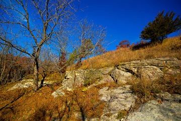
Photo by Josh Mayer
Situated on a ridge of St. Peter Sandstone capped by a thin layer of Platteville dolomite, this prairie and savanna complex harbors a very diverse flora. Bedrock ledges, low cliffs, and a small pinnacle add geologic interest to the site. Sandy, dry to dry-mesic prairie occupies the steep, south-facing flank of the ridge. Prairie grasses, including little bluestem, side-oats grama, and hairy grama, are interspersed with a host of prairie forbs, including such rarities as prairie fame-flower, prairie dandelion, and upland boneset.
Patches of the common prickly pear cactus attest to the thin soils and droughty conditions here. The prairie grades into bur oak savanna and dry-mesic oak/hickory woodland. More than 235 native plant species have been recorded from the natural area. Many bird species use the site, including red-headed woodpeckers and field sparrows, two species of greatest conservation need in Wisconsin. Parrish Oak Savanna is owned and managed by The Prairie Enthusiasts and was designated a State Natural Area in 2015.
Very few State Natural Areas have public facilities, but nearly all are open for various recreational activities as indicated below. Generally, there are no picnic areas, restrooms, or other developments. Parking lots or designated parking areas are noted on individual SNA pages and maps. If a developed trail is present, it will normally be noted on the SNA map and/or under the Maps tab. A compass and topographic map or a GPS unit are useful tools for exploring larger, isolated SNAs.
The good majority of SNAs are isolated and have few or no facilities. Some SNAs have vehicle access lanes or parking lots, but their accessibility may vary depending on weather conditions. Parking lots and lanes are not plowed during winter. Hiking trails may be nonexistent or consist of undeveloped footpaths. A GPS unit or compass and a detailed topographic map are useful tools for exploring larger SNAs.
Non-DNR lands
Entrance fees: For non-DNR-owned SNAs, we are unaware of any vehicle or admission fees. However, please contact the landowner for more information.
Hunting and trapping
Other activities
Other allowable activities such as - but not limited to camping, geocaching and bicycling are determined by the landowner. Please contact them directly or visit their websites for details.
Location
Dane County. T7N-R6E, Section 29. 29 acres.
Driving directions
From the junction of County Trunk Highways ID and F in Blue Mounds, go north on F for 3.3 miles, then west on Moyer Road for 0.2 miles to a road shoulder pull-off north of the road.
The DNR's state natural areas program is comprised of lands owned by the state, private conservation organizations, municipalities, other governmental agencies, educational institutions and private individuals. While the majority of SNAs are open to the public, access may vary according to individual ownership policies. Public use restrictions may apply due to public safety, or to protect endangered or threatened species or unique natural features. Lands may be temporarily closed due to specific management activities.
Users are encouraged to contact the landowner for more specific details. The data shown on these maps have been obtained from various sources, and are of varying age, reliability, and resolution. The data may contain errors or omissions and should not be interpreted as a legal representation of legal ownership boundaries. To create your custom map where you can zoom to a specific location, please use the DNR's Mapping Application.
Parrish Oak Savanna is owned by: The Prairie Enthusiasts