Pan Hollow
No. 545
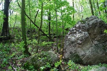
Photo by Josh Mayer
Pan Hollow is a large, flat-bottomed quartzite gorge that supports a diversity of southern forest community types. Being situated between the large forested blocks of Pine Hollow and Baxter's Hollow, it is an integral part of the larger Baraboo Hills complex. The site features southern dry, dry-mesic, and mesic forest communities in addition to bedrock glade, and fast, soft-water streams.
Large populations of a state-threatened sedge and the spring ephemeral false mermaid occur in the southern mesic forest along the stream gorge. Of note is the presence of the largest diversity of breeding forest interior songbirds in the Hills. Many of these species have experienced dramatic population declines due to the loss of high-quality, extensive blocks of forest. Keeping this landscape in forest cover will benefit these birds as well as other forest-dependent species. Pan Hollow is owned by the Wisconsin Chapter of The Nature Conservancy and was designated a State Natural Area in 2007.
Very few State Natural Areas have public facilities, but nearly all are open for various recreational activities as indicated below. Generally, there are no picnic areas, restrooms, or other developments. Parking lots or designated parking areas are noted on individual SNA pages and maps. If a developed trail is present, it will normally be noted on the SNA map and/or under the Maps tab. A compass and topographic map or a GPS unit are useful tools for exploring larger, isolated SNAs.
The good majority of SNAs are isolated and have few or no facilities. Some SNAs have vehicle access lanes or parking lots, but their accessibility may vary depending on weather conditions. Parking lots and lanes are not plowed during winter. Hiking trails may be nonexistent or consist of undeveloped footpaths. A GPS unit or compass and a detailed topographic map are useful tools for exploring larger SNAs.
Non-DNR lands
Entrance fees: For non-DNR-owned SNAs, we are unaware of any vehicle or admission fees. However, please contact the landowner for more information.
Hunting and trapping
For hunting opportunities on Nature Conservancy land, visit The Nature Conservancy's Deer Management [exit DNR].
Other activities
Other allowable activities such as - but not limited to camping, geocaching and bicycling are determined by the landowner. Please contact them directly or visit their websites for details.
Location
Sauk County. T10N-R5E, Section 2. 100 acres.
Driving directions
From the intersection of U.S. Highway 12 and State Highway 78 in Sauk City, go west on Highway 12 for 7.6 miles, then west on County Highway C for 3.7 miles, continue west on Freedom Road for 1.7 miles, then west on Hilltop Road for 0.3 miles. Park and walk north into the site.
The DNR's state natural areas program is comprised of lands owned by the state, private conservation organizations, municipalities, other governmental agencies, educational institutions and private individuals. While the majority of SNAs are open to the public, access may vary according to individual ownership policies. Public use restrictions may apply due to public safety, or to protect endangered or threatened species or unique natural features. Lands may be temporarily closed due to specific management activities.
Users are encouraged to contact the landowner for more specific details. The data shown on these maps have been obtained from various sources, and are of varying age, reliability, and resolution. The data may contain errors or omissions and should not be interpreted as a legal representation of legal ownership boundaries. To create your custom map where you can zoom to a specific location, please use the DNR's Mapping Application.
Pan Hollow is owned by: The Nature Conservancy