Page Creek Marsh
No. 330
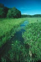
Photo by Thomas A. Meyer/DNR
Located in the central sands of Wisconsin, Page Creek Marsh is a large wetland preserve that supports a rich diversity of plants, rare meadow birds, and waterfowl. Dominant plant communities are northern and southern sedge meadows and sandy oak savanna. Also present are fens, wet-mesic prairie, bog, and seepage lakes. Page Creek winds northwest near the west edge of the marsh through gently rolling farmland enhanced by remnants of native prairie and savanna. Broad sedge meadows, cat-tails, and areas of open water afford habitat to a variety of rare species.
A portion of the sedge meadow is of boggy northern type with plant species including wiregrass, cotton grass, bog bean, and northern bog aster. The area is host to numerous other plant species including marsh marigold, lake sedge, turtlehead, water dock, sensitive fern, and wild rice. Page Creek Marsh is of particular value as a staging area for sandhill cranes during their fall migration. Luxuriant with emergent aquatic plants, the secure, deep-water habitat of the marsh provides cover for large numbers of birds every season. Page Creek Marsh is owned by The Nature Conservatory and was designated a State Natural Area in 1996.
Very few State Natural Areas have public facilities, but nearly all are open for various recreational activities as indicated below. Generally, there are no picnic areas, restrooms, or other developments. Parking lots or designated parking areas are noted on individual SNA pages and maps. If a developed trail is present, it will normally be noted on the SNA map and/or under the Maps tab. A compass and topographic map or a GPS unit are useful tools for exploring larger, isolated SNAs.
The good majority of SNAs are isolated and have few or no facilities. Some SNAs have vehicle access lanes or parking lots, but their accessibility may vary depending on weather conditions. Parking lots and lanes are not plowed during winter. Hiking trails may be nonexistent or consist of undeveloped footpaths. A GPS unit or compass and a detailed topographic map are useful tools for exploring larger SNAs.
Non-DNR lands
Entrance fees: For non-DNR-owned SNAs, we are unaware of any vehicle or admission fees. However, please contact the landowner for more information.
Hunting and trapping
For hunting opportunities on Nature Conservancy land, visit The Nature Conservancy's Deer Management [exit DNR].
Other activities
Other allowable activities such as - but not limited to camping, geocaching and bicycling are determined by the landowner. Please contact them directly or visit their websites for details.
Location
Marquette County. T15N-R9E, Sections 21, 22, 25, 26. 643 acres.
Driving directions
From the intersection of U.S. Highway 51/39 and County Highway D just west of Packwaukee, go east on County D for 3.45 miles, then north on K for 0.5 miles to a parking area on the east side of the road.
The DNR's state natural areas program is comprised of lands owned by the state, private conservation organizations, municipalities, other governmental agencies, educational institutions and private individuals. While the majority of SNAs are open to the public, access may vary according to individual ownership policies. Public use restrictions may apply due to public safety, or to protect endangered or threatened species or unique natural features. Lands may be temporarily closed due to specific management activities.
Users are encouraged to contact the landowner for more specific details. The data shown on these maps have been obtained from various sources, and are of varying age, reliability, and resolution. The data may contain errors or omissions and should not be interpreted as a legal representation of legal ownership boundaries. To create your custom map where you can zoom to a specific location, please use the DNR's Mapping Application.
Page Creek Marsh is owned by: The Nature Conservancy