Orion Mussel Bed
No. 298
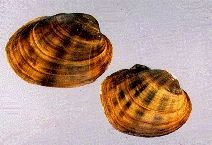
Photo by USFWS photo
Orion Mussel Beds features a narrow corridor of Wisconsin River bottom and adjacent shoreline that is critical habitat for numerous rare animals. Fifteen rare animals are known from this site including mussels, mayflies, dragonflies, beetles, and fish. The river bottom contains a rock and gravel substrate with underwater sandstone ledges, which contrasts with the shifting sands that are more typical of the Lower Wisconsin River bottom. The firm substrate that supports these species is restricted to a very narrow zone beginning at the shoreline and extending south for 4.2 miles.
A diversity of rare mussels, invertebrates and fish are found here. In addition to the mussel beds, the natural area includes 1,500 feet of Wisconsin River frontage that supports one of the best preserved and least disturbed mound groups in Wisconsin. Built by the Effigy Mound Culture of the Late Woodland period between AD 750 and 1000, the site features the Twin Lizards and Catfish mound group, which consists of 15 mounds including 3 birds, 1 bear, 2 lizards, 1 conical, and 8 lineal mounds. The mounds were carefully sculpted and looked much as they did when they were built. Orion Mussel Beds is owned by the DNR and was designated a State Natural Area in 1996.
Very few State Natural Areas have public facilities, but nearly all are open for a variety of recreational activities as indicated below. Generally, there are no picnic areas, restrooms, or other developments. Parking lots or designated parking areas are noted on individual SNA pages and maps. If a developed trail is present, it will normally be noted on the SNA map and/or under the Maps tab. A compass and topographic map or a GPS unit are useful tools for exploring larger, isolated SNAs.
The good majority of SNAs are isolated and have few or no facilities. Some SNAs have vehicle access lanes or parking lots, but their accessibility may vary depending on weather conditions. Parking lots and lanes are not plowed during winter. Hiking trails may be nonexistent or consist of undeveloped footpaths. A GPS unit or compass and a detailed topographic map are useful tools for exploring larger SNAs.
Entrance fees: Except for Parfrey's Glen, the Cambrian Outlook in the Dells of the Wisconsin River, SNAs within State Parks and some within State Forests, all other DNR-owned SNAs do not have any admission fees. For more information, see Wis. Admin. Code NR 45 [exit DNR]. For non-DNR-owned SNAs, we are unaware of any vehicle or admission fees. However, please contact the landowner for more information.
Allowable activities: DNR-owned land
The activities listed below are generally allowed on all DNR-owned SNA lands. Exceptions to this list of public uses, such as SNAs closed to hunting, are noted above and posted with signs on the property site.
- Hiking
- Fishing
- Cross country skiing
- Hunting
- Trapping
- Scientific research (permit required [PDF])
- Outdoor education
- Wild edibles (What is this?)
- Pets (Rules)
- Wildlife viewing
Prohibited activities: all SNAs
Although a handful of sites allow activities like primitive camping (e.g. Lower Chippewa River on sand bars) or horseback riding (e.g. S. Kettle Moraine), the activities listed below are generally prohibited on DNR-owned SNAs.
- Camping and campfires
- Collecting of animals (other than legally harvested species), non-edible fungi, rocks, minerals, fossils, archaeological artifacts, soil, downed wood, or any other natural material, alive or dead.
- Collecting for scientific research requires a permit issued by the DNR
- Collecting of plants including seeds, roots or other non-edible parts of herbaceous plants such as wildflowers or grasses
- Drones: Flying-related activities, including the use of drones, hang-gliders and model airplanes, are prohibited. Permission may be issued by the SNA Program for the use of drones for educational or research purposes
- Geocaching
- Horseback riding
- Rock climbing
- Vehicles, including bicycles, ATVs, aircraft, and snowmobiles except on trails and roadways designated for their use.
For rules governing state-owned SNAs and other state lands, please consult Chapter NR 45 Wis. Admin. Code [exit DNR].
Location
Within the Lower Wisconsin State Riverway, Richland County. T8N-R1E, Sections 4, 5, 6. T9N-R1E, Sections 33, 34, 35. 170 acres.
Driving directions
From the intersection of Highways 14, 60, and JJ in Gotham, go west on 60 2.4 miles, to the upper part of the beds. The natural area encompasses the northern part of the river for 3 miles downstream. From the intersection of Highways 14, 60, and JJ in Gotham, go west on 60 2.4 miles, to the upper part of the beds. The natural area encompasses the northern part of the river for 3 miles downstream. For the Effigy Mound Group, at the intersection of Highway 60 and County OO just east of Orion, go south on Ginger’s Road 0.1 mile, then west on Aigner Lane to its end (0.25 miles) into the natural area.
The DNR's state natural areas program is comprised of lands owned by the state, private conservation organizations, municipalities, other governmental agencies, educational institutions and private individuals. While the majority of SNAs are open to the public, access may vary according to individual ownership policies. Public use restrictions may apply due to public safety, or to protect endangered or threatened species or unique natural features. Lands may be temporarily closed due to specific management activities.
Users are encouraged to contact the landowner for more specific details. The data shown on these maps have been obtained from various sources, and are of varying age, reliability, and resolution. The data may contain errors or omissions and should not be interpreted as a legal representation of legal ownership boundaries. To create your custom map where you can zoom to a specific location, please use the DNR's Mapping Application.
Orion Mussel Bed is owned by: Wisconsin DNR