Nourse Sugarbush
No. 534
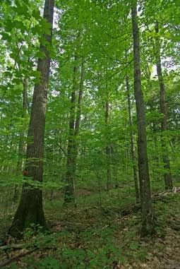
Photo by Thomas A. Meyer/DNR
Nourse Sugarbush features an old-growth northern mesic forest on the northwest flank of Mt. Ashwabay, a steep-sided hill rising over 700' above Lake Superior. To the south, the land rises abruptly to the Bayfield outwash sands and supports dry forest and barren communities. In contrast, although situated on the same glacial outwash, the sugarbush developed in the shadow of Mt. Ashwabay, which protected it from fire. Large hemlock and sugar maple, some towering 100 feet high, dominate the canopy with associated species of yellow birch, basswood, paper birch, and red oak. The understory is composed of ironwood, sugar maple, and balsam fir.
The shrub layer is sparse; ground cover includes wild sarsaparilla, hairy sweet cicely, doll's-eyes, rosy twisted-stalk, intermediate wood fern, partridgeberry, and violets. Densely packed territories of the black-throated blue warbler indicate the forest contains optimal habitat for this rare species. The site has a long history of maple sugaring - for hundreds of years, the Ojibwe tapped the large trees for maple syrup production and diagonal slash marks from early sap collecting are still visible on some trees. Nourse Sugarbush was purchased by the Mt. Ashwabay Outdoor Education Foundation with assistance from the Bayfield Regional Conservancy and later donated to the State of Wisconsin. It was designated a State Natural Area in 2006.
Very few State Natural Areas have public facilities, but nearly all are open for a variety of recreational activities as indicated below. Generally, there are no picnic areas, restrooms, or other developments. Parking lots or designated parking areas are noted on individual SNA pages and maps. If a developed trail is present, it will normally be noted on the SNA map and/or under the Maps tab. A compass and topographic map or a GPS unit are useful tools for exploring larger, isolated SNAs.
The good majority of SNAs are isolated and have few or no facilities. Some SNAs have vehicle access lanes or parking lots, but their accessibility may vary depending on weather conditions. Parking lots and lanes are not plowed during winter. Hiking trails may be nonexistent or consist of undeveloped footpaths. A GPS unit or compass and a detailed topographic map are useful tools for exploring larger SNAs.
Entrance fees: Except for Parfrey's Glen, the Cambrian Outlook in the Dells of the Wisconsin River, SNAs within State Parks and some within State Forests, all other DNR-owned SNAs do not have any admission fees. For more information, see Wis. Admin. Code NR 45 [exit DNR]. For non-DNR-owned SNAs, we are unaware of any vehicle or admission fees. However, please contact the landowner for more information.
Allowable activities: DNR-owned land
The activities listed below are generally allowed on all DNR-owned SNA lands. Exceptions to this list of public uses, such as SNAs closed to hunting, are noted above and posted with signs on the property site.
- Hiking
- Fishing
- Cross country skiing
- Hunting
- Trapping
- Scientific research (permit required [PDF])
- Outdoor education
- Wild edibles (What is this?)
- Pets (Rules)
- Wildlife viewing
Prohibited activities: all SNAs
Although a handful of sites allow activities like primitive camping (e.g. Lower Chippewa River on sand bars) or horseback riding (e.g. S. Kettle Moraine), the activities listed below are generally prohibited on DNR-owned SNAs.
- Camping and campfires
- Collecting of animals (other than legally harvested species), non-edible fungi, rocks, minerals, fossils, archaeological artifacts, soil, downed wood, or any other natural material, alive or dead.
- Collecting for scientific research requires a permit issued by the DNR
- Collecting of plants including seeds, roots or other non-edible parts of herbaceous plants such as wildflowers or grasses
- Drones: Flying-related activities, including the use of drones, hang-gliders and model airplanes, are prohibited. Permission may be issued by the SNA Program for the use of drones for educational or research purposes
- Geocaching
- Horseback riding
- Rock climbing
- Vehicles, including bicycles, ATVs, aircraft, and snowmobiles except on trails and roadways designated for their use.
For rules governing state-owned SNAs and other state lands, please consult Chapter NR 45 Wis. Admin. Code [exit DNR].
Location
Bayfield County. T50N-R4W, Sections 19, 29, 30. T50N-R5W, Sections 24, 25. 438 acres.
Driving directions
From Washburn, go north on Highway 13 for 9 miles, then west on Whiting Road for about 3.8 miles, then north on Jammer Hill Road for 0.5 miles. Park along the road. Follow the Bayfield County Chasta ski trail north and east 1.5 miles to the tin shed and cabin located in the heart of Sugarbush. Or from Washburn, go north on Highway 13 for 10 miles, then north on Ski Hill Road for 2 miles to the Ashwabay Ski Center Parking lot. On foot, skis or snowshoe, follow the Sugarbush Trail about 2 miles northwest to the Nourse Sugarbush tin shed and cabin.
The DNR's state natural areas program is comprised of lands owned by the state, private conservation organizations, municipalities, other governmental agencies, educational institutions and private individuals. While the majority of SNAs are open to the public, access may vary according to individual ownership policies. Public use restrictions may apply due to public safety, or to protect endangered or threatened species or unique natural features. Lands may be temporarily closed due to specific management activities.
Users are encouraged to contact the landowner for more specific details. The data shown on these maps have been obtained from various sources, and are of varying age, reliability, and resolution. The data may contain errors or omissions and should not be interpreted as a legal representation of legal ownership boundaries. To create your custom map where you can zoom to a specific location, please use the DNR's Mapping Application.
Nourse Sugarbush is owned by: Wisconsin DNR